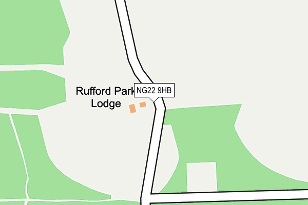
NG22 9HB is in Rufford, Newark. NG22 9HB is located in the Rainworth North & Rufford electoral ward, within the local authority district of Newark and Sherwood and the English Parliamentary constituency of Sherwood. The Sub Integrated Care Board (ICB) Location is NHS Nottingham and Nottinghamshire ICB - 52R and the police force is Nottinghamshire. This postcode has been in use since January 1980.


GetTheData
Source: OS OpenMap – Local (Ordnance Survey)
Source: OS VectorMap District (Ordnance Survey)
Licence: Open Government Licence (requires attribution)
| Easting | 464949 |
| Northing | 363155 |
| Latitude | 53.161567 |
| Longitude | -1.030047 |
GetTheData
Source: Open Postcode Geo
Licence: Open Government Licence
| Locality | Rufford |
| Town/City | Newark |
| Country | England |
| Postcode District | NG22 |
| ➜ NG22 open data dashboard ➜ See where NG22 is on a map | |
GetTheData
Source: Land Registry Price Paid Data
Licence: Open Government Licence
Elevation or altitude of NG22 9HB as distance above sea level:
| Metres | Feet | |
|---|---|---|
| Elevation | 70m | 230ft |
Elevation is measured from the approximate centre of the postcode, to the nearest point on an OS contour line from OS Terrain 50, which has contour spacing of ten vertical metres.
➜ How high above sea level am I? Find the elevation of your current position using your device's GPS.
GetTheData
Source: Open Postcode Elevation
Licence: Open Government Licence
| Ward | Rainworth North & Rufford |
| Constituency | Sherwood |
GetTheData
Source: ONS Postcode Database
Licence: Open Government Licence
| Deerdale Farm (Old Rufford Road) | Bilsthorpe | 1,623m |
GetTheData
Source: NaPTAN
Licence: Open Government Licence
| Percentage of properties with Next Generation Access | 100.0% |
| Percentage of properties with Superfast Broadband | 0.0% |
| Percentage of properties with Ultrafast Broadband | 0.0% |
| Percentage of properties with Full Fibre Broadband | 0.0% |
Superfast Broadband is between 30Mbps and 300Mbps
Ultrafast Broadband is > 300Mbps
| Percentage of properties unable to receive 2Mbps | 0.0% |
| Percentage of properties unable to receive 5Mbps | 0.0% |
| Percentage of properties unable to receive 10Mbps | 0.0% |
| Percentage of properties unable to receive 30Mbps | 100.0% |
GetTheData
Source: Ofcom
Licence: Ofcom Terms of Use (requires attribution)
GetTheData
Source: ONS Postcode Database
Licence: Open Government Licence


➜ Get more ratings from the Food Standards Agency
GetTheData
Source: Food Standards Agency
Licence: FSA terms & conditions
| Last Collection | |||
|---|---|---|---|
| Location | Mon-Fri | Sat | Distance |
| Maythorn Drive | 16:00 | 07:30 | 1,590m |
| Centre Parcs | 14:00 | 08:30 | 1,871m |
| Valley Road | 17:00 | 11:00 | 2,102m |
GetTheData
Source: Dracos
Licence: Creative Commons Attribution-ShareAlike
| Facility | Distance |
|---|---|
| Bilsthorpe Sports Ground Eakring Road, Bilsthorpe Grass Pitches | 1.8km |
| Center Parcs (Sherwood Forest) Old Rufford Road, Rufford Swimming Pool, Health and Fitness Gym, Sports Hall, Studio, Squash Courts, Artificial Grass Pitch, Outdoor Tennis Courts, Golf | 1.9km |
| Rufford Park Golf & Country Club Rufford Lane, Rufford, Newark Golf | 2.1km |
GetTheData
Source: Active Places
Licence: Open Government Licence
| School | Phase of Education | Distance |
|---|---|---|
| Bilsthorpe Flying High Academy Crompton Road, Bilsthorpe, Newark, NG22 8PS | Primary | 2.5km |
| Wellow House School Newark Road, Wellow, notts, ng22 0ea | Not applicable | 3.6km |
| King Edwin Primary and Nursery School Fourth Avenue, Edwinstowe, King Edwin Primary School, Mansfield, NG21 9NS | Primary | 4.4km |
GetTheData
Source: Edubase
Licence: Open Government Licence
The below table lists the International Territorial Level (ITL) codes (formerly Nomenclature of Territorial Units for Statistics (NUTS) codes) and Local Administrative Units (LAU) codes for NG22 9HB:
| ITL 1 Code | Name |
|---|---|
| TLF | East Midlands (England) |
| ITL 2 Code | Name |
| TLF1 | Derbyshire and Nottinghamshire |
| ITL 3 Code | Name |
| TLF15 | North Nottinghamshire |
| LAU 1 Code | Name |
| E07000175 | Newark and Sherwood |
GetTheData
Source: ONS Postcode Directory
Licence: Open Government Licence
The below table lists the Census Output Area (OA), Lower Layer Super Output Area (LSOA), and Middle Layer Super Output Area (MSOA) for NG22 9HB:
| Code | Name | |
|---|---|---|
| OA | E00144174 | |
| LSOA | E01028295 | Newark and Sherwood 005A |
| MSOA | E02005897 | Newark and Sherwood 005 |
GetTheData
Source: ONS Postcode Directory
Licence: Open Government Licence
| NG22 9HA | 974m | |
| NG22 8SX | Eakring Road | 1395m |
| NG22 9DE | May Lodge Drive | 1515m |
| NG22 8SU | Eakring Road | 1590m |
| NG22 8QJ | North Drive | 2016m |
| NG22 9DD | Old Rufford Road | 2050m |
| NG22 8QQ | The Green | 2064m |
| NG22 8RL | Lansbury Road | 2072m |
| NG22 8SY | Deerdale Lane | 2085m |
| NG22 8QH | Valley Road | 2095m |
GetTheData
Source: Open Postcode Geo; Land Registry Price Paid Data
Licence: Open Government Licence