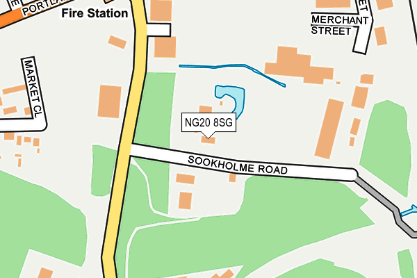
NG20 8SG is located in the Shirebrook South electoral ward, within the local authority district of Bolsover and the English Parliamentary constituency of Bolsover. The Sub Integrated Care Board (ICB) Location is NHS Derby and Derbyshire ICB - 15M and the police force is Derbyshire. This postcode has been in use since January 1980.


GetTheData
Source: OS OpenMap – Local (Ordnance Survey)
Source: OS VectorMap District (Ordnance Survey)
Licence: Open Government Licence (requires attribution)
| Easting | 453059 |
| Northing | 367371 |
| Latitude | 53.200794 |
| Longitude | -1.207159 |
GetTheData
Source: Open Postcode Geo
Licence: Open Government Licence
| Country | England |
| Postcode District | NG20 |
| ➜ NG20 open data dashboard ➜ See where NG20 is on a map ➜ Where is Shirebrook? | |
GetTheData
Source: Land Registry Price Paid Data
Licence: Open Government Licence
Elevation or altitude of NG20 8SG as distance above sea level:
| Metres | Feet | |
|---|---|---|
| Elevation | 80m | 262ft |
Elevation is measured from the approximate centre of the postcode, to the nearest point on an OS contour line from OS Terrain 50, which has contour spacing of ten vertical metres.
➜ How high above sea level am I? Find the elevation of your current position using your device's GPS.
GetTheData
Source: Open Postcode Elevation
Licence: Open Government Licence
| Ward | Shirebrook South |
| Constituency | Bolsover |
GetTheData
Source: ONS Postcode Database
Licence: Open Government Licence
| June 2023 | Violence and sexual offences | On or near Market Street | 374m |
| May 2023 | Other crime | On or near Market Street | 374m |
| May 2023 | Other crime | On or near Market Street | 374m |
| ➜ Get more crime data in our Crime section | |||
GetTheData
Source: data.police.uk
Licence: Open Government Licence
| Sports Direct (Meadow Lane) | Shirebrook | 259m |
| Shire Hotel (Station Road) | Shirebrook | 368m |
| Shire Hotel (Station Road) | Shirebrook | 406m |
| Vernon Street (Station Road) | Shirebrook | 416m |
| Langwith Road End (Langwith Road) | Shirebrook | 425m |
| Shirebrook Station | 0.5km |
| Langwith - Whaley Thorns Station | 3.5km |
| Mansfield Woodhouse Station | 4.2km |
GetTheData
Source: NaPTAN
Licence: Open Government Licence
| Percentage of properties with Next Generation Access | 100.0% |
| Percentage of properties with Superfast Broadband | 100.0% |
| Percentage of properties with Ultrafast Broadband | 0.0% |
| Percentage of properties with Full Fibre Broadband | 0.0% |
Superfast Broadband is between 30Mbps and 300Mbps
Ultrafast Broadband is > 300Mbps
| Percentage of properties unable to receive 2Mbps | 0.0% |
| Percentage of properties unable to receive 5Mbps | 0.0% |
| Percentage of properties unable to receive 10Mbps | 0.0% |
| Percentage of properties unable to receive 30Mbps | 0.0% |
GetTheData
Source: Ofcom
Licence: Ofcom Terms of Use (requires attribution)
GetTheData
Source: ONS Postcode Database
Licence: Open Government Licence


➜ Get more ratings from the Food Standards Agency
GetTheData
Source: Food Standards Agency
Licence: FSA terms & conditions
| Last Collection | |||
|---|---|---|---|
| Location | Mon-Fri | Sat | Distance |
| Station Road | 17:30 | 09:15 | 383m |
| Shirebrook Post Office | 17:00 | 11:00 | 504m |
| Main St / Central Drive | 17:00 | 09:15 | 729m |
GetTheData
Source: Dracos
Licence: Creative Commons Attribution-ShareAlike
| Facility | Distance |
|---|---|
| Everlast Gyms (Shirebrook) Weighbridge Road, Weighbridge Road, Shirebrook Health and Fitness Gym | 303m |
| Shirebrook Recreation Ground Langwith Road, Shirebrook, Mansfield Grass Pitches | 557m |
| Shirebrook Town Football Club Langwith Road, Shirebrook Grass Pitches | 703m |
GetTheData
Source: Active Places
Licence: Open Government Licence
| School | Phase of Education | Distance |
|---|---|---|
| Model Village Primary School Central Drive, Shirebrook, Mansfield, NG20 8BQ | Primary | 741m |
| St Joseph's Catholic Primary School, A Voluntary Academy Langwith Road, Langwith Junction, MANSFIELD, NG20 9RP | Primary | 907m |
| Brookfield Primary School Burlington Avenue, Langwith Junction, Mansfield, NG20 9AD | Primary | 1.2km |
GetTheData
Source: Edubase
Licence: Open Government Licence
The below table lists the International Territorial Level (ITL) codes (formerly Nomenclature of Territorial Units for Statistics (NUTS) codes) and Local Administrative Units (LAU) codes for NG20 8SG:
| ITL 1 Code | Name |
|---|---|
| TLF | East Midlands (England) |
| ITL 2 Code | Name |
| TLF1 | Derbyshire and Nottinghamshire |
| ITL 3 Code | Name |
| TLF12 | East Derbyshire |
| LAU 1 Code | Name |
| E07000033 | Bolsover |
GetTheData
Source: ONS Postcode Directory
Licence: Open Government Licence
The below table lists the Census Output Area (OA), Lower Layer Super Output Area (LSOA), and Middle Layer Super Output Area (MSOA) for NG20 8SG:
| Code | Name | |
|---|---|---|
| OA | E00098655 | |
| LSOA | E01019507 | Bolsover 007D |
| MSOA | E02004051 | Bolsover 007 |
GetTheData
Source: ONS Postcode Directory
Licence: Open Government Licence
| NG20 8GB | Weighbridge Road | 154m |
| NG20 8SF | Sookholme Road | 262m |
| NG20 8AE | Market Close | 279m |
| NG20 8SQ | Hardwick Street | 348m |
| NG20 8SZ | Station Road | 361m |
| NG20 8UU | Hereward Close | 368m |
| NG20 8UE | Station Road | 370m |
| NG20 8SE | Sookholme Road | 381m |
| NG20 8SS | Vernon Street Industrial Estate | 384m |
| NG20 8UT | Hereward Close | 388m |
GetTheData
Source: Open Postcode Geo; Land Registry Price Paid Data
Licence: Open Government Licence