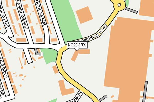
NG20 8RX is located in the Shirebrook South electoral ward, within the local authority district of Bolsover and the English Parliamentary constituency of Bolsover. The Sub Integrated Care Board (ICB) Location is NHS Derby and Derbyshire ICB - 15M and the police force is Derbyshire. This postcode has been in use since March 2013.


GetTheData
Source: OS OpenMap – Local (Ordnance Survey)
Source: OS VectorMap District (Ordnance Survey)
Licence: Open Government Licence (requires attribution)
| Easting | 452849 |
| Northing | 366889 |
| Latitude | 53.196483 |
| Longitude | -1.210382 |
GetTheData
Source: Open Postcode Geo
Licence: Open Government Licence
| Country | England |
| Postcode District | NG20 |
| ➜ NG20 open data dashboard ➜ See where NG20 is on a map ➜ Where is Shirebrook? | |
GetTheData
Source: Land Registry Price Paid Data
Licence: Open Government Licence
Elevation or altitude of NG20 8RX as distance above sea level:
| Metres | Feet | |
|---|---|---|
| Elevation | 100m | 328ft |
Elevation is measured from the approximate centre of the postcode, to the nearest point on an OS contour line from OS Terrain 50, which has contour spacing of ten vertical metres.
➜ How high above sea level am I? Find the elevation of your current position using your device's GPS.
GetTheData
Source: Open Postcode Elevation
Licence: Open Government Licence
| Ward | Shirebrook South |
| Constituency | Bolsover |
GetTheData
Source: ONS Postcode Database
Licence: Open Government Licence
| January 2024 | Public order | On or near Briar Close | 432m |
| January 2024 | Violence and sexual offences | On or near Briar Close | 432m |
| December 2023 | Burglary | On or near Briar Close | 432m |
| ➜ Get more crime data in our Crime section | |||
GetTheData
Source: data.police.uk
Licence: Open Government Licence
| Recreation Drive | Shirebrook | 338m |
| Sports Direct (Meadow Lane) | Shirebrook | 340m |
| The Grange (Link Road) | Shirebrook | 344m |
| Recreation Drive | Shirebrook | 348m |
| Vale Drive (Field Drive) | Shirebrook | 388m |
| Shirebrook Station | 1km |
| Mansfield Woodhouse Station | 3.7km |
| Langwith - Whaley Thorns Station | 3.9km |
GetTheData
Source: NaPTAN
Licence: Open Government Licence
GetTheData
Source: ONS Postcode Database
Licence: Open Government Licence


➜ Get more ratings from the Food Standards Agency
GetTheData
Source: Food Standards Agency
Licence: FSA terms & conditions
| Last Collection | |||
|---|---|---|---|
| Location | Mon-Fri | Sat | Distance |
| Model Village Ex-post Office | 17:00 | 11:00 | 417m |
| Main St / Central Drive | 17:00 | 09:15 | 792m |
| Shirebrook Post Office | 17:00 | 11:00 | 839m |
GetTheData
Source: Dracos
Licence: Creative Commons Attribution-ShareAlike
| Facility | Distance |
|---|---|
| Everlast Gyms (Shirebrook) Weighbridge Road, Weighbridge Road, Shirebrook Health and Fitness Gym | 262m |
| Model Village Sports Ground Vale Drive, Shirebrook, Mansfield Grass Pitches | 289m |
| Shirebrook Leisure Centre Park Road, Shirebrook, Mansfield Sports Hall, Health and Fitness Gym, Squash Courts, Artificial Grass Pitch | 1.1km |
GetTheData
Source: Active Places
Licence: Open Government Licence
| School | Phase of Education | Distance |
|---|---|---|
| Model Village Primary School Central Drive, Shirebrook, Mansfield, NG20 8BQ | Primary | 532m |
| St Joseph's Catholic Primary School, A Voluntary Academy Langwith Road, Langwith Junction, MANSFIELD, NG20 9RP | Primary | 1.4km |
| The Park Infant & Nursery School Orchard Close, Park Road, Shirebrook, Mansfield, NG20 8JX | Primary | 1.5km |
GetTheData
Source: Edubase
Licence: Open Government Licence
The below table lists the International Territorial Level (ITL) codes (formerly Nomenclature of Territorial Units for Statistics (NUTS) codes) and Local Administrative Units (LAU) codes for NG20 8RX:
| ITL 1 Code | Name |
|---|---|
| TLF | East Midlands (England) |
| ITL 2 Code | Name |
| TLF1 | Derbyshire and Nottinghamshire |
| ITL 3 Code | Name |
| TLF12 | East Derbyshire |
| LAU 1 Code | Name |
| E07000033 | Bolsover |
GetTheData
Source: ONS Postcode Directory
Licence: Open Government Licence
The below table lists the Census Output Area (OA), Lower Layer Super Output Area (LSOA), and Middle Layer Super Output Area (MSOA) for NG20 8RX:
| Code | Name | |
|---|---|---|
| OA | E00098676 | |
| LSOA | E01019511 | Bolsover 007E |
| MSOA | E02004051 | Bolsover 007 |
GetTheData
Source: ONS Postcode Directory
Licence: Open Government Licence
| NG20 8RN | Acreage Lane | 161m |
| NG20 8RH | Coronation Drive | 190m |
| NG20 8RS | South Avenue | 236m |
| NG20 8RQ | Vale Drive | 260m |
| NG20 8RR | Brunner Avenue | 277m |
| NG20 8RG | Recreation Drive | 294m |
| NG20 8RP | Brunner Avenue | 304m |
| NG20 8BX | Recreation Drive | 327m |
| NG20 8RW | Swanwick Avenue | 334m |
| NG20 8RF | Sherwood Drive | 348m |
GetTheData
Source: Open Postcode Geo; Land Registry Price Paid Data
Licence: Open Government Licence