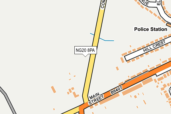
NG20 8PA is located in the Shirebrook North electoral ward, within the local authority district of Bolsover and the English Parliamentary constituency of Bolsover. The Sub Integrated Care Board (ICB) Location is NHS Derby and Derbyshire ICB - 15M and the police force is Derbyshire. This postcode has been in use since January 1980.


GetTheData
Source: OS OpenMap – Local (Ordnance Survey)
Source: OS VectorMap District (Ordnance Survey)
Licence: Open Government Licence (requires attribution)
| Easting | 451373 |
| Northing | 367266 |
| Latitude | 53.200016 |
| Longitude | -1.232413 |
GetTheData
Source: Open Postcode Geo
Licence: Open Government Licence
| Country | England |
| Postcode District | NG20 |
| ➜ NG20 open data dashboard ➜ See where NG20 is on a map ➜ Where is Shirebrook? | |
GetTheData
Source: Land Registry Price Paid Data
Licence: Open Government Licence
Elevation or altitude of NG20 8PA as distance above sea level:
| Metres | Feet | |
|---|---|---|
| Elevation | 120m | 394ft |
Elevation is measured from the approximate centre of the postcode, to the nearest point on an OS contour line from OS Terrain 50, which has contour spacing of ten vertical metres.
➜ How high above sea level am I? Find the elevation of your current position using your device's GPS.
GetTheData
Source: Open Postcode Elevation
Licence: Open Government Licence
| Ward | Shirebrook North |
| Constituency | Bolsover |
GetTheData
Source: ONS Postcode Database
Licence: Open Government Licence
| July 2023 | Violence and sexual offences | On or near Bracken Road | 347m |
| January 2023 | Violence and sexual offences | On or near Bracken Road | 347m |
| June 2022 | Anti-social behaviour | On or near Sports/Recreation Area | 110m |
| ➜ Get more crime data in our Crime section | |||
GetTheData
Source: data.police.uk
Licence: Open Government Licence
| Common Lane (Main Street) | Shirebrook | 126m |
| Common Lane (Main Street) | Shirebrook | 161m |
| Cemetery (B6407) | Shirebrook | 184m |
| Cemetery (B6407) | Shirebrook | 222m |
| Bracken Road | Shirebrook | 392m |
| Shirebrook Station | 2.1km |
| Langwith - Whaley Thorns Station | 3.9km |
| Mansfield Woodhouse Station | 4.5km |
GetTheData
Source: NaPTAN
Licence: Open Government Licence
| Percentage of properties with Next Generation Access | 100.0% |
| Percentage of properties with Superfast Broadband | 100.0% |
| Percentage of properties with Ultrafast Broadband | 0.0% |
| Percentage of properties with Full Fibre Broadband | 0.0% |
Superfast Broadband is between 30Mbps and 300Mbps
Ultrafast Broadband is > 300Mbps
| Percentage of properties unable to receive 2Mbps | 0.0% |
| Percentage of properties unable to receive 5Mbps | 0.0% |
| Percentage of properties unable to receive 10Mbps | 0.0% |
| Percentage of properties unable to receive 30Mbps | 0.0% |
GetTheData
Source: Ofcom
Licence: Ofcom Terms of Use (requires attribution)
GetTheData
Source: ONS Postcode Database
Licence: Open Government Licence


➜ Get more ratings from the Food Standards Agency
GetTheData
Source: Food Standards Agency
Licence: FSA terms & conditions
| Last Collection | |||
|---|---|---|---|
| Location | Mon-Fri | Sat | Distance |
| Warren Terrace | 17:00 | 09:15 | 248m |
| Hawthorne Avenue | 16:30 | 11:15 | 424m |
| Stinting Lane | 16:00 | 11:00 | 588m |
GetTheData
Source: Dracos
Licence: Creative Commons Attribution-ShareAlike
| Facility | Distance |
|---|---|
| Warren Terrace Recreation Ground Main Street, Shirebrook, Mansfield Grass Pitches | 121m |
| Park Road Recreation Ground Park Road, Shirebrook, Mansfield Grass Pitches | 1.1km |
| Shirebrook Academy (Closed) Common Lane, Shirebrook, Mansfield Sports Hall, Grass Pitches | 1.1km |
GetTheData
Source: Active Places
Licence: Open Government Licence
| School | Phase of Education | Distance |
|---|---|---|
| Model Village Primary School Central Drive, Shirebrook, Mansfield, NG20 8BQ | Primary | 1km |
| Shirebrook Academy Common Lane, Shirebrook, Mansfield, NG20 8QF | Secondary | 1.1km |
| The Park Infant & Nursery School Orchard Close, Park Road, Shirebrook, Mansfield, NG20 8JX | Primary | 1.2km |
GetTheData
Source: Edubase
Licence: Open Government Licence
The below table lists the International Territorial Level (ITL) codes (formerly Nomenclature of Territorial Units for Statistics (NUTS) codes) and Local Administrative Units (LAU) codes for NG20 8PA:
| ITL 1 Code | Name |
|---|---|
| TLF | East Midlands (England) |
| ITL 2 Code | Name |
| TLF1 | Derbyshire and Nottinghamshire |
| ITL 3 Code | Name |
| TLF12 | East Derbyshire |
| LAU 1 Code | Name |
| E07000033 | Bolsover |
GetTheData
Source: ONS Postcode Directory
Licence: Open Government Licence
The below table lists the Census Output Area (OA), Lower Layer Super Output Area (LSOA), and Middle Layer Super Output Area (MSOA) for NG20 8PA:
| Code | Name | |
|---|---|---|
| OA | E00170735 | |
| LSOA | E01019512 | Bolsover 006D |
| MSOA | E02004050 | Bolsover 006 |
GetTheData
Source: ONS Postcode Directory
Licence: Open Government Licence
| NG20 8DS | Main Street | 109m |
| NG20 8FG | Carnation Road | 139m |
| NG20 8FF | Lupin Close | 193m |
| NG20 8FH | Bracken Road | 216m |
| NG20 8DT | Main Street | 219m |
| NG20 8FE | Lavender Close | 280m |
| NG20 8DR | Main Street | 281m |
| NG20 8DP | Hill Crest | 308m |
| NG20 8DU | Main Street | 320m |
| NG20 8FB | Bracken Road | 333m |
GetTheData
Source: Open Postcode Geo; Land Registry Price Paid Data
Licence: Open Government Licence