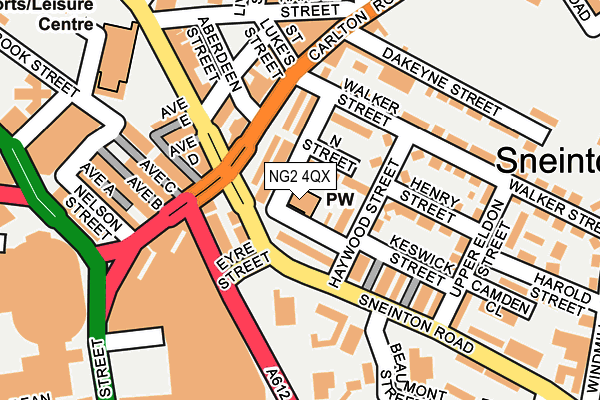
NG2 4QX is located in the St. Ann's electoral ward, within the unitary authority of Nottingham and the English Parliamentary constituency of Nottingham East. The Sub Integrated Care Board (ICB) Location is NHS Nottingham and Nottinghamshire ICB - 52R and the police force is Nottinghamshire. This postcode has been in use since February 2012.


GetTheData
Source: OS OpenMap – Local (Ordnance Survey)
Source: OS VectorMap District (Ordnance Survey)
Licence: Open Government Licence (requires attribution)
| Easting | 458164 |
| Northing | 339928 |
| Latitude | 52.953585 |
| Longitude | -1.135700 |
GetTheData
Source: Open Postcode Geo
Licence: Open Government Licence
| Country | England |
| Postcode District | NG2 |
| ➜ NG2 open data dashboard ➜ See where NG2 is on a map ➜ Where is Nottingham? | |
GetTheData
Source: Land Registry Price Paid Data
Licence: Open Government Licence
Elevation or altitude of NG2 4QX as distance above sea level:
| Metres | Feet | |
|---|---|---|
| Elevation | 30m | 98ft |
Elevation is measured from the approximate centre of the postcode, to the nearest point on an OS contour line from OS Terrain 50, which has contour spacing of ten vertical metres.
➜ How high above sea level am I? Find the elevation of your current position using your device's GPS.
GetTheData
Source: Open Postcode Elevation
Licence: Open Government Licence
| Ward | St. Ann's |
| Constituency | Nottingham East |
GetTheData
Source: ONS Postcode Database
Licence: Open Government Licence
| January 2024 | Violence and sexual offences | On or near Paxton Gardens | 428m |
| January 2024 | Violence and sexual offences | On or near Paxton Gardens | 428m |
| November 2023 | Criminal damage and arson | On or near Paxton Gardens | 428m |
| ➜ Get more crime data in our Crime section | |||
GetTheData
Source: data.police.uk
Licence: Open Government Licence
| Eyre Street (Sneinton Road) | Sneinton | 51m |
| Eyre Street (Sneinton Road) | Sneinton | 92m |
| Eyre Street (Manvers Street) | Sneinton | 111m |
| Southwell Road | Nottingham | 152m |
| Southwell Road | Sneinton | 156m |
| Lace Market Tram Stop (Fletcher Gate) | Nottingham | 653m |
| Nottingham Station Tram Stop (N/A) | Nottingham | 1,004m |
| Old Market Square Tram Stop (South Parade) | Nottingham | 1,012m |
| Royal Centre Tram Stop (Wollaton Street) | Nottingham | 1,118m |
| Ntu Tram Stop (Goldsmith Street) | Nottingham Trent University In City Centre | 1,437m |
| Nottingham Station | 1km |
| Netherfield Station | 3.9km |
| Carlton Station | 4km |
GetTheData
Source: NaPTAN
Licence: Open Government Licence
GetTheData
Source: ONS Postcode Database
Licence: Open Government Licence


➜ Get more ratings from the Food Standards Agency
GetTheData
Source: Food Standards Agency
Licence: FSA terms & conditions
| Last Collection | |||
|---|---|---|---|
| Location | Mon-Fri | Sat | Distance |
| Plough Lane | 18:30 | 11:00 | 293m |
| Newark Street | 17:30 | 12:30 | 295m |
| Windmill Lane | 17:30 | 11:00 | 332m |
GetTheData
Source: Dracos
Licence: Creative Commons Attribution-ShareAlike
| Facility | Distance |
|---|---|
| H3 Gym Longden Street, Nottingham Health and Fitness Gym | 119m |
| Bushido Mma Academy (Closed) Ashley Street, Nottingham Health and Fitness Gym, Studio | 222m |
| Victoria Leisure Centre (Nottingham) Gedling Street, Nottingham Sports Hall, Swimming Pool, Health and Fitness Gym, Squash Courts, Studio | 255m |
GetTheData
Source: Active Places
Licence: Open Government Licence
| School | Phase of Education | Distance |
|---|---|---|
| William Booth Primary and Nursery School Notintone Street, Sneinton, Nottingham, NG2 4QF | Primary | 290m |
| Sneinton St Stephen's CofE Primary School Windmill Lane, Sneinton, Nottingham, NG2 4QB | Primary | 345m |
| Sutherland House School Bath Street, Nottingham, NG1 1DA | Not applicable | 414m |
GetTheData
Source: Edubase
Licence: Open Government Licence
The below table lists the International Territorial Level (ITL) codes (formerly Nomenclature of Territorial Units for Statistics (NUTS) codes) and Local Administrative Units (LAU) codes for NG2 4QX:
| ITL 1 Code | Name |
|---|---|
| TLF | East Midlands (England) |
| ITL 2 Code | Name |
| TLF1 | Derbyshire and Nottinghamshire |
| ITL 3 Code | Name |
| TLF14 | Nottingham |
| LAU 1 Code | Name |
| E06000018 | Nottingham |
GetTheData
Source: ONS Postcode Directory
Licence: Open Government Licence
The below table lists the Census Output Area (OA), Lower Layer Super Output Area (LSOA), and Middle Layer Super Output Area (MSOA) for NG2 4QX:
| Code | Name | |
|---|---|---|
| OA | E00173505 | |
| LSOA | E01033405 | Nottingham 023G |
| MSOA | E02002890 | Nottingham 023 |
GetTheData
Source: ONS Postcode Directory
Licence: Open Government Licence
| NG2 4PY | Haywood Court | 45m |
| NG2 4PX | Byron Court | 47m |
| NG2 4PZ | Keswick Court | 47m |
| NG2 4QY | West Walk | 52m |
| NG2 4PA | Sneinton Road | 68m |
| NG2 4PB | Manvers Street | 89m |
| NG2 4QA | Morley Court | 91m |
| NG2 4QU | Haywood Street | 106m |
| NG3 2DG | Carlton Road | 115m |
| NG2 4QW | Keswick Street | 128m |
GetTheData
Source: Open Postcode Geo; Land Registry Price Paid Data
Licence: Open Government Licence
| Bath Street | At Any Time | 170m |
| Brook Street | At Any Time | 215m |
| Bath Street | At Any Time | 226m |
GetTheData
Source: Disabled parking spaces, Nottingham City Council, 19/02/2013
Licence: Open Government Licence