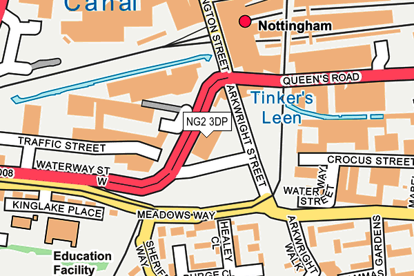
NG2 3DP is located in the Meadows electoral ward, within the unitary authority of Nottingham and the English Parliamentary constituency of Nottingham South. The Sub Integrated Care Board (ICB) Location is NHS Nottingham and Nottinghamshire ICB - 52R and the police force is Nottinghamshire. This postcode has been in use since January 1980.


GetTheData
Source: OS OpenMap – Local (Ordnance Survey)
Source: OS VectorMap District (Ordnance Survey)
Licence: Open Government Licence (requires attribution)
| Easting | 457391 |
| Northing | 339035 |
| Latitude | 52.945662 |
| Longitude | -1.147359 |
GetTheData
Source: Open Postcode Geo
Licence: Open Government Licence
| Country | England |
| Postcode District | NG2 |
➜ See where NG2 is on a map ➜ Where is Nottingham? | |
GetTheData
Source: Land Registry Price Paid Data
Licence: Open Government Licence
Elevation or altitude of NG2 3DP as distance above sea level:
| Metres | Feet | |
|---|---|---|
| Elevation | 30m | 98ft |
Elevation is measured from the approximate centre of the postcode, to the nearest point on an OS contour line from OS Terrain 50, which has contour spacing of ten vertical metres.
➜ How high above sea level am I? Find the elevation of your current position using your device's GPS.
GetTheData
Source: Open Postcode Elevation
Licence: Open Government Licence
| Ward | Meadows |
| Constituency | Nottingham South |
GetTheData
Source: ONS Postcode Database
Licence: Open Government Licence
| London Road Temp (Arcwright Street) | Nottingham | 48m |
| Arkwright Street | Meadows | 65m |
| Nottingham Railway Station (Carrington Street) | Nottingham | 145m |
| Traffic Street (Waterway Street) | Meadows | 152m |
| Sheriffs Way (Meadows Way) | Meadows | 170m |
| Nottingham Station Tram Stop (N/A) | Nottingham | 177m |
| Queens Walk Tram Stop (Queens Walk) | Meadows | 380m |
| Meadows Way West Tram Stop (Meadows Way) | Meadows | 676m |
| Lace Market Tram Stop (Fletcher Gate) | Nottingham | 840m |
| Meadows Embankment Tram Stop (Queens Walk) | Meadows | 846m |
| Nottingham Station | 0.2km |
| Netherfield Station | 4.9km |
| Beeston Station | 4.9km |
GetTheData
Source: NaPTAN
Licence: Open Government Licence
GetTheData
Source: ONS Postcode Database
Licence: Open Government Licence


➜ Get more ratings from the Food Standards Agency
GetTheData
Source: Food Standards Agency
Licence: FSA terms & conditions
| Last Collection | |||
|---|---|---|---|
| Location | Mon-Fri | Sat | Distance |
| Carrington Street | 18:45 | 12:30 | 215m |
| The Meadows Post Office | 17:00 | 12:00 | 271m |
| Maid Marion Way | 18:30 | 11:00 | 484m |
GetTheData
Source: Dracos
Licence: Creative Commons Attribution-ShareAlike
| Risk of NG2 3DP flooding from rivers and sea | Low |
| ➜ NG2 3DP flood map | |
GetTheData
Source: Open Flood Risk by Postcode
Licence: Open Government Licence
The below table lists the International Territorial Level (ITL) codes (formerly Nomenclature of Territorial Units for Statistics (NUTS) codes) and Local Administrative Units (LAU) codes for NG2 3DP:
| ITL 1 Code | Name |
|---|---|
| TLF | East Midlands (England) |
| ITL 2 Code | Name |
| TLF1 | Derbyshire and Nottinghamshire |
| ITL 3 Code | Name |
| TLF14 | Nottingham |
| LAU 1 Code | Name |
| E06000018 | Nottingham |
GetTheData
Source: ONS Postcode Directory
Licence: Open Government Licence
The below table lists the Census Output Area (OA), Lower Layer Super Output Area (LSOA), and Middle Layer Super Output Area (MSOA) for NG2 3DP:
| Code | Name | |
|---|---|---|
| OA | E00069996 | |
| LSOA | E01013871 | Nottingham 040B |
| MSOA | E02006905 | Nottingham 040 |
GetTheData
Source: ONS Postcode Directory
Licence: Open Government Licence
| NG2 2JR | Arkwright Street | 85m |
| NG2 2HL | Healey Close | 155m |
| NG2 3DU | Queens Road | 157m |
| NG2 3DT | Queens Road | 164m |
| NG2 2HJ | Conduit Close | 170m |
| NG2 2HN | Arkwright Walk | 210m |
| NG2 3AS | Queens Road | 230m |
| NG2 1NT | Kinglake Place | 238m |
| NG2 3AJ | Station Street | 238m |
| NG2 3LB | Lammas Gardens | 240m |
GetTheData
Source: Open Postcode Geo; Land Registry Price Paid Data
Licence: Open Government Licence
| Station Street | 7.30am-midnight | 222m |
| Trent Street | At Any Time | 289m |
| Station Street | At Any Time | 475m |
GetTheData
Source: Disabled parking spaces, Nottingham City Council, 19/02/2013
Licence: Open Government Licence