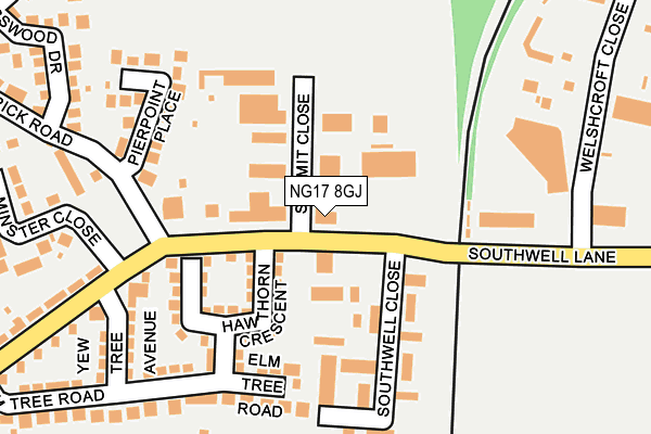
NG17 8GJ is located in the Larwood electoral ward, within the local authority district of Ashfield and the English Parliamentary constituency of Ashfield. The Sub Integrated Care Board (ICB) Location is NHS Nottingham and Nottinghamshire ICB - 52R and the police force is Nottinghamshire. This postcode has been in use since January 1980.


GetTheData
Source: OS OpenMap – Local (Ordnance Survey)
Source: OS VectorMap District (Ordnance Survey)
Licence: Open Government Licence (requires attribution)
| Easting | 450065 |
| Northing | 356884 |
| Latitude | 53.106825 |
| Longitude | -1.253610 |
GetTheData
Source: Open Postcode Geo
Licence: Open Government Licence
| Country | England |
| Postcode District | NG17 |
| ➜ NG17 open data dashboard ➜ See where NG17 is on a map ➜ Where is Kirkby-in-Ashfield? | |
GetTheData
Source: Land Registry Price Paid Data
Licence: Open Government Licence
Elevation or altitude of NG17 8GJ as distance above sea level:
| Metres | Feet | |
|---|---|---|
| Elevation | 160m | 525ft |
Elevation is measured from the approximate centre of the postcode, to the nearest point on an OS contour line from OS Terrain 50, which has contour spacing of ten vertical metres.
➜ How high above sea level am I? Find the elevation of your current position using your device's GPS.
GetTheData
Source: Open Postcode Elevation
Licence: Open Government Licence
| Ward | Larwood |
| Constituency | Ashfield |
GetTheData
Source: ONS Postcode Database
Licence: Open Government Licence
| April 2023 | Public order | On or near Ivy Grove | 362m |
| April 2023 | Anti-social behaviour | On or near Ivy Grove | 362m |
| June 2022 | Public order | On or near Southwell Close | 151m |
| ➜ Get more crime data in our Crime section | |||
GetTheData
Source: data.police.uk
Licence: Open Government Licence
| Summit Close (Southwell Lane) | Kirkby In Ashfield | 40m |
| Summit Close (Southwell Lane) | Kirkby In Ashfield | 67m |
| Welshcroft Close (Southwell Lane) | Kirkby In Ashfield | 255m |
| Elm Tree Road (Southwell Lane) | Kirkby In Ashfield | 256m |
| Elm Tree Road (Southwell Lane) | Kirkby In Ashfield | 292m |
| Kirkby in Ashfield Station | 0.7km |
| Sutton Parkway Station | 1km |
| Newstead Station | 4.6km |
GetTheData
Source: NaPTAN
Licence: Open Government Licence
GetTheData
Source: ONS Postcode Database
Licence: Open Government Licence


➜ Get more ratings from the Food Standards Agency
GetTheData
Source: Food Standards Agency
Licence: FSA terms & conditions
| Last Collection | |||
|---|---|---|---|
| Location | Mon-Fri | Sat | Distance |
| Southwell Close | 16:30 | 11:30 | 103m |
| Elm Tree Road | 16:45 | 11:30 | 295m |
| Alexandra Street | 17:00 | 12:00 | 549m |
GetTheData
Source: Dracos
Licence: Creative Commons Attribution-ShareAlike
| Facility | Distance |
|---|---|
| Greenwood Primary School Sutton Middle Lane, Kirkby-in-ashfield, Nottingham Grass Pitches, Sports Hall | 576m |
| B.r.s.a Ground (Closed) Millers Way, Kirkby-in-ashfield, Nottingham Grass Pitches | 656m |
| Ashfield Rufc (Penny Emma Way) Penny Emma Way, Kirkby In Ashfield Grass Pitches | 770m |
GetTheData
Source: Active Places
Licence: Open Government Licence
| School | Phase of Education | Distance |
|---|---|---|
| Greenwood Primary and Nursery School Sutton Middle Lane, Kirkby-in-Ashfield, Nottingham, NG17 8FX | Primary | 578m |
| The West Park Academy Vernon Road, Kirkby-in-Ashfield, Nottingham, NG17 8EE | Primary | 666m |
| Leamington Primary and Nursery Academy Clare Road, Sutton-in-Ashfield, NG17 5BB | Primary | 948m |
GetTheData
Source: Edubase
Licence: Open Government Licence
The below table lists the International Territorial Level (ITL) codes (formerly Nomenclature of Territorial Units for Statistics (NUTS) codes) and Local Administrative Units (LAU) codes for NG17 8GJ:
| ITL 1 Code | Name |
|---|---|
| TLF | East Midlands (England) |
| ITL 2 Code | Name |
| TLF1 | Derbyshire and Nottinghamshire |
| ITL 3 Code | Name |
| TLF15 | North Nottinghamshire |
| LAU 1 Code | Name |
| E07000170 | Ashfield |
GetTheData
Source: ONS Postcode Directory
Licence: Open Government Licence
The below table lists the Census Output Area (OA), Lower Layer Super Output Area (LSOA), and Middle Layer Super Output Area (MSOA) for NG17 8GJ:
| Code | Name | |
|---|---|---|
| OA | E00142407 | |
| LSOA | E01027954 | Ashfield 007D |
| MSOA | E02005825 | Ashfield 007 |
GetTheData
Source: ONS Postcode Directory
Licence: Open Government Licence
| NG17 8FJ | Hawthorn Crescent | 95m |
| NG17 8FL | Southwell Lane | 132m |
| NG17 8FH | Privet Avenue | 132m |
| NG17 8GP | Southwell Close | 156m |
| NG17 8QZ | Pierpoint Place | 161m |
| NG17 8FG | Elm Tree Road | 186m |
| NG17 8FN | Southwell Lane | 192m |
| NG17 8FE | Elm Tree Road | 210m |
| NG17 8GN | Southwell Close | 219m |
| NG17 8GL | Minster Close | 227m |
GetTheData
Source: Open Postcode Geo; Land Registry Price Paid Data
Licence: Open Government Licence