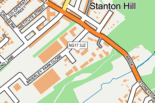
NG17 3JZ is located in the Stanton Hill & Teversal electoral ward, within the local authority district of Ashfield and the English Parliamentary constituency of Ashfield. The Sub Integrated Care Board (ICB) Location is NHS Nottingham and Nottinghamshire ICB - 52R and the police force is Nottinghamshire. This postcode has been in use since January 1993.


GetTheData
Source: OS OpenMap – Local (Ordnance Survey)
Source: OS VectorMap District (Ordnance Survey)
Licence: Open Government Licence (requires attribution)
| Easting | 448607 |
| Northing | 360417 |
| Latitude | 53.138697 |
| Longitude | -1.274855 |
GetTheData
Source: Open Postcode Geo
Licence: Open Government Licence
| Country | England |
| Postcode District | NG17 |
➜ See where NG17 is on a map ➜ Where is Stanton Hill? | |
GetTheData
Source: Land Registry Price Paid Data
Licence: Open Government Licence
Elevation or altitude of NG17 3JZ as distance above sea level:
| Metres | Feet | |
|---|---|---|
| Elevation | 160m | 525ft |
Elevation is measured from the approximate centre of the postcode, to the nearest point on an OS contour line from OS Terrain 50, which has contour spacing of ten vertical metres.
➜ How high above sea level am I? Find the elevation of your current position using your device's GPS.
GetTheData
Source: Open Postcode Elevation
Licence: Open Government Licence
| Ward | Stanton Hill & Teversal |
| Constituency | Ashfield |
GetTheData
Source: ONS Postcode Database
Licence: Open Government Licence
| Marshall Terrace (Stoneyford Road) | Stanton Hill | 123m |
| Marshall Terrace (Stoneyford Road) | Stanton Hill | 135m |
| Stoneyford Road | Sutton In Ashfield | 346m |
| New Lane (Fackley Road) | Stanton Hill | 359m |
| New Lane (Fackley Road) | Stanton Hill | 371m |
| Sutton Parkway Station | 3.4km |
| Kirkby in Ashfield Station | 4.5km |
| Mansfield Woodhouse Station | 5.6km |
GetTheData
Source: NaPTAN
Licence: Open Government Licence
GetTheData
Source: ONS Postcode Database
Licence: Open Government Licence


➜ Get more ratings from the Food Standards Agency
GetTheData
Source: Food Standards Agency
Licence: FSA terms & conditions
| Last Collection | |||
|---|---|---|---|
| Location | Mon-Fri | Sat | Distance |
| Stanton Hill Post Office | 16:30 | 11:00 | 201m |
| West Hill Post Office | 16:30 | 11:00 | 533m |
| Herrods View | 16:30 | 11:00 | 568m |
GetTheData
Source: Dracos
Licence: Creative Commons Attribution-ShareAlike
The below table lists the International Territorial Level (ITL) codes (formerly Nomenclature of Territorial Units for Statistics (NUTS) codes) and Local Administrative Units (LAU) codes for NG17 3JZ:
| ITL 1 Code | Name |
|---|---|
| TLF | East Midlands (England) |
| ITL 2 Code | Name |
| TLF1 | Derbyshire and Nottinghamshire |
| ITL 3 Code | Name |
| TLF15 | North Nottinghamshire |
| LAU 1 Code | Name |
| E07000170 | Ashfield |
GetTheData
Source: ONS Postcode Directory
Licence: Open Government Licence
The below table lists the Census Output Area (OA), Lower Layer Super Output Area (LSOA), and Middle Layer Super Output Area (MSOA) for NG17 3JZ:
| Code | Name | |
|---|---|---|
| OA | E00142552 | |
| LSOA | E01027981 | Ashfield 001C |
| MSOA | E02005819 | Ashfield 001 |
GetTheData
Source: ONS Postcode Directory
Licence: Open Government Licence
| NG17 3GJ | Stoneyford Road | 66m |
| NG17 3GL | Stoneyford Road | 117m |
| NG17 3GH | Brand Lane | 153m |
| NG17 3GP | Gardiner Terrace | 166m |
| NG17 3GN | Cochrane Terrace | 168m |
| NG17 3GQ | Marshall Terrace | 173m |
| NG17 3HD | Institute Street | 216m |
| NG17 3GR | Bainbridge Terrace | 217m |
| NG17 3GE | Longden Terrace | 235m |
| NG17 3GA | High Street | 261m |
GetTheData
Source: Open Postcode Geo; Land Registry Price Paid Data
Licence: Open Government Licence