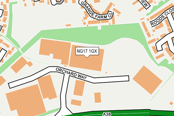
NG17 1GX is located in the Ashfields electoral ward, within the local authority district of Ashfield and the English Parliamentary constituency of Ashfield. The Sub Integrated Care Board (ICB) Location is NHS Nottingham and Nottinghamshire ICB - 52R and the police force is Nottinghamshire. This postcode has been in use since June 1981.


GetTheData
Source: OS OpenMap – Local (Ordnance Survey)
Source: OS VectorMap District (Ordnance Survey)
Licence: Open Government Licence (requires attribution)
| Easting | 448288 |
| Northing | 357835 |
| Latitude | 53.115518 |
| Longitude | -1.280011 |
GetTheData
Source: Open Postcode Geo
Licence: Open Government Licence
| Country | England |
| Postcode District | NG17 |
| ➜ NG17 open data dashboard ➜ See where NG17 is on a map ➜ Where is Sutton in Ashfield? | |
GetTheData
Source: Land Registry Price Paid Data
Licence: Open Government Licence
Elevation or altitude of NG17 1GX as distance above sea level:
| Metres | Feet | |
|---|---|---|
| Elevation | 170m | 558ft |
Elevation is measured from the approximate centre of the postcode, to the nearest point on an OS contour line from OS Terrain 50, which has contour spacing of ten vertical metres.
➜ How high above sea level am I? Find the elevation of your current position using your device's GPS.
GetTheData
Source: Open Postcode Elevation
Licence: Open Government Licence
| Ward | Ashfields |
| Constituency | Ashfield |
GetTheData
Source: ONS Postcode Database
Licence: Open Government Licence
| October 2023 | Vehicle crime | On or near Primrose Way | 460m |
| July 2023 | Violence and sexual offences | On or near Coalfields Close | 274m |
| April 2023 | Vehicle crime | On or near Coalfields Close | 274m |
| ➜ Get more crime data in our Crime section | |||
GetTheData
Source: data.police.uk
Licence: Open Government Licence
| Redbarn Way | Sutton In Ashfield | 322m |
| Fonton Hall Drive (Alfreton Road) | Fulwood | 430m |
| Henning Lane (Alfreton Road) | Sutton In Ashfield | 436m |
| Fonton Hall Drive (Alfreton Road) | Fulwood | 445m |
| Henning Lane (Alfreton Road) | Sutton In Ashfield | 468m |
| Sutton Parkway Station | 2.3km |
| Kirkby in Ashfield Station | 2.5km |
GetTheData
Source: NaPTAN
Licence: Open Government Licence
GetTheData
Source: ONS Postcode Database
Licence: Open Government Licence


➜ Get more ratings from the Food Standards Agency
GetTheData
Source: Food Standards Agency
Licence: FSA terms & conditions
| Last Collection | |||
|---|---|---|---|
| Location | Mon-Fri | Sat | Distance |
| Fonton Hall Drive | 16:45 | 11:00 | 449m |
| Kirkby Road | 17:00 | 11:00 | 848m |
| Westbourne Road | 17:00 | 10:30 | 1,081m |
GetTheData
Source: Dracos
Licence: Creative Commons Attribution-ShareAlike
| Facility | Distance |
|---|---|
| Calladine Park Bluebell Wood Way, Sutton In Ashfield Grass Pitches | 132m |
| Charnwood Street Recreation Ground (Closed) Charnwood Street, Sutton-in-ashfield Grass Pitches | 800m |
| Ashfield School Sutton Road, Kirkby-in-ashfield, Nottingham Athletics, Sports Hall, Artificial Grass Pitch, Health and Fitness Gym, Swimming Pool, Grass Pitches, Studio | 884m |
GetTheData
Source: Active Places
Licence: Open Government Licence
| School | Phase of Education | Distance |
|---|---|---|
| Mapplewells Primary and Nursery School Henning Lane, Sutton-in-Ashfield, NG17 1HU | Primary | 527m |
| Ashfield Comprehensive School Sutton Road, Kirkby-in-Ashfield, Nottingham, NG17 8HP | Secondary | 884m |
| Westbourne School Huthwaite School, Sutton-in-Ashfield, NG17 2EL | Not applicable | 1.1km |
GetTheData
Source: Edubase
Licence: Open Government Licence
The below table lists the International Territorial Level (ITL) codes (formerly Nomenclature of Territorial Units for Statistics (NUTS) codes) and Local Administrative Units (LAU) codes for NG17 1GX:
| ITL 1 Code | Name |
|---|---|
| TLF | East Midlands (England) |
| ITL 2 Code | Name |
| TLF1 | Derbyshire and Nottinghamshire |
| ITL 3 Code | Name |
| TLF15 | North Nottinghamshire |
| LAU 1 Code | Name |
| E07000170 | Ashfield |
GetTheData
Source: ONS Postcode Directory
Licence: Open Government Licence
The below table lists the Census Output Area (OA), Lower Layer Super Output Area (LSOA), and Middle Layer Super Output Area (MSOA) for NG17 1GX:
| Code | Name | |
|---|---|---|
| OA | E00142606 | |
| LSOA | E01027992 | Ashfield 006F |
| MSOA | E02005824 | Ashfield 006 |
GetTheData
Source: ONS Postcode Directory
Licence: Open Government Licence
| NG17 1NJ | Grange Farm Close | 160m |
| NG17 1JX | The Dumbles | 226m |
| NG17 1JW | Bluebell Wood Way | 248m |
| NG17 1HY | Fox Covert Close | 252m |
| NG17 1LP | Hill Top View | 266m |
| NG17 1JR | Coalfield Close | 275m |
| NG17 1HA | Bloomer Wood View | 294m |
| NG17 1HG | Blackthorn Way | 299m |
| NG17 1LL | Redbarn Way | 302m |
| NG17 1NL | Roods Close | 303m |
GetTheData
Source: Open Postcode Geo; Land Registry Price Paid Data
Licence: Open Government Licence