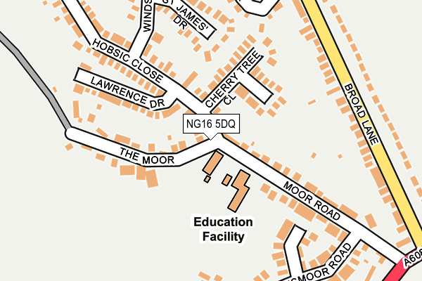
NG16 5DQ is located in the Underwood electoral ward, within the local authority district of Ashfield and the English Parliamentary constituency of Ashfield. The Sub Integrated Care Board (ICB) Location is NHS Nottingham and Nottinghamshire ICB - 52R and the police force is Nottinghamshire. This postcode has been in use since November 2015.


GetTheData
Source: OS OpenMap – Local (Ordnance Survey)
Source: OS VectorMap District (Ordnance Survey)
Licence: Open Government Licence (requires attribution)
| Easting | 447912 |
| Northing | 350522 |
| Latitude | 53.049839 |
| Longitude | -1.286713 |
GetTheData
Source: Open Postcode Geo
Licence: Open Government Licence
| Country | England |
| Postcode District | NG16 |
| ➜ NG16 open data dashboard ➜ See where NG16 is on a map | |
GetTheData
Source: Land Registry Price Paid Data
Licence: Open Government Licence
Elevation or altitude of NG16 5DQ as distance above sea level:
| Metres | Feet | |
|---|---|---|
| Elevation | 110m | 361ft |
Elevation is measured from the approximate centre of the postcode, to the nearest point on an OS contour line from OS Terrain 50, which has contour spacing of ten vertical metres.
➜ How high above sea level am I? Find the elevation of your current position using your device's GPS.
GetTheData
Source: Open Postcode Elevation
Licence: Open Government Licence
| Ward | Underwood |
| Constituency | Ashfield |
GetTheData
Source: ONS Postcode Database
Licence: Open Government Licence
| June 2022 | Violence and sexual offences | On or near Mansfield Road | 480m |
| June 2022 | Violence and sexual offences | On or near Mansfield Road | 480m |
| April 2022 | Anti-social behaviour | On or near Mansfield Road | 480m |
| ➜ Get more crime data in our Crime section | |||
GetTheData
Source: data.police.uk
Licence: Open Government Licence
| Institute (Mansfield Road) | Underwood | 454m |
| Institute (Mansfield Road) | Underwood | 470m |
| Institute (Alfreton Road) | Underwood | 474m |
| Institute (Alfreton Road) | Underwood | 475m |
| Sandhill Road (Mansfield Road) | Underwood | 521m |
| Langley Mill Station | 4.6km |
| Newstead Station | 4.9km |
GetTheData
Source: NaPTAN
Licence: Open Government Licence
GetTheData
Source: ONS Postcode Database
Licence: Open Government Licence


➜ Get more ratings from the Food Standards Agency
GetTheData
Source: Food Standards Agency
Licence: FSA terms & conditions
| Last Collection | |||
|---|---|---|---|
| Location | Mon-Fri | Sat | Distance |
| Underwood Tso | 17:15 | 10:30 | 730m |
| Middlebrook Road | 16:30 | 10:30 | 1,208m |
| Cordy Lane | 16:30 | 10:30 | 1,438m |
GetTheData
Source: Dracos
Licence: Creative Commons Attribution-ShareAlike
| Facility | Distance |
|---|---|
| Bracken Park (Underwood Villa Fc) Felley Mill Lane North, Underwood, Nottingham Grass Pitches | 524m |
| Friezeland Recreation Ground Alfreton Road, Underwood, Nottingham Grass Pitches | 565m |
| Underwood Ce Primary School Main Road, Underwood, Nottingham Grass Pitches | 965m |
GetTheData
Source: Active Places
Licence: Open Government Licence
| School | Phase of Education | Distance |
|---|---|---|
| Underwood Church of England Primary School Main Road, Underwood, Nottingham, NG16 5GN | Primary | 972m |
| Bagthorpe Primary School School Road, Bagthorpe, Nottingham, NG16 5HB | Primary | 1.2km |
| Brinsley Primary and Nursery School Moor Road, Brinsley, Nottingham, NG16 5AZ | Primary | 2.1km |
GetTheData
Source: Edubase
Licence: Open Government Licence
The below table lists the International Territorial Level (ITL) codes (formerly Nomenclature of Territorial Units for Statistics (NUTS) codes) and Local Administrative Units (LAU) codes for NG16 5DQ:
| ITL 1 Code | Name |
|---|---|
| TLF | East Midlands (England) |
| ITL 2 Code | Name |
| TLF1 | Derbyshire and Nottinghamshire |
| ITL 3 Code | Name |
| TLF15 | North Nottinghamshire |
| LAU 1 Code | Name |
| E07000170 | Ashfield |
GetTheData
Source: ONS Postcode Directory
Licence: Open Government Licence
The below table lists the Census Output Area (OA), Lower Layer Super Output Area (LSOA), and Middle Layer Super Output Area (MSOA) for NG16 5DQ:
| Code | Name | |
|---|---|---|
| OA | E00142627 | |
| LSOA | E01027993 | Ashfield 012C |
| MSOA | E02005830 | Ashfield 012 |
GetTheData
Source: ONS Postcode Directory
Licence: Open Government Licence
| NG16 5FE | Mansfield Road | 417m |
| NG16 5FF | Mansfield Road | 439m |
| NG16 5GA | Alfreton Road | 490m |
| NG16 5GB | Alfreton Road | 513m |
| NG16 5FQ | Alfreton Road | 538m |
| NG16 5FX | Sandhill Road | 577m |
| NG16 5ES | Beech Court | 601m |
| NG16 5QZ | Lawrence Park | 627m |
| NG16 5GE | Smalley Close | 641m |
| NG16 5FS | Church Lane | 652m |
GetTheData
Source: Open Postcode Geo; Land Registry Price Paid Data
Licence: Open Government Licence