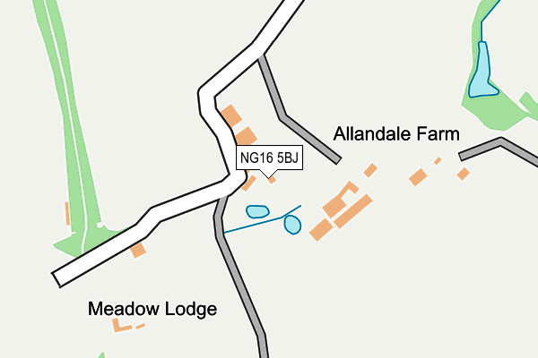
NG16 5BJ is in Brinsley, Nottingham. NG16 5BJ is located in the Brinsley electoral ward, within the local authority district of Broxtowe and the English Parliamentary constituency of Ashfield. The Sub Integrated Care Board (ICB) Location is NHS Nottingham and Nottinghamshire ICB - 52R and the police force is Nottinghamshire. This postcode has been in use since January 1980.


GetTheData
Source: OS OpenMap – Local (Ordnance Survey)
Source: OS VectorMap District (Ordnance Survey)
Licence: Open Government Licence (requires attribution)
| Easting | 445346 |
| Northing | 349844 |
| Latitude | 53.043949 |
| Longitude | -1.325086 |
GetTheData
Source: Open Postcode Geo
Licence: Open Government Licence
| Locality | Brinsley |
| Town/City | Nottingham |
| Country | England |
| Postcode District | NG16 |
| ➜ NG16 open data dashboard ➜ See where NG16 is on a map | |
GetTheData
Source: Land Registry Price Paid Data
Licence: Open Government Licence
Elevation or altitude of NG16 5BJ as distance above sea level:
| Metres | Feet | |
|---|---|---|
| Elevation | 80m | 262ft |
Elevation is measured from the approximate centre of the postcode, to the nearest point on an OS contour line from OS Terrain 50, which has contour spacing of ten vertical metres.
➜ How high above sea level am I? Find the elevation of your current position using your device's GPS.
GetTheData
Source: Open Postcode Elevation
Licence: Open Government Licence
| Ward | Brinsley |
| Constituency | Ashfield |
GetTheData
Source: ONS Postcode Database
Licence: Open Government Licence
| Clumber Avenue (High Street) | Brinsley | 759m |
| Clumber Avenue (High Street) | Brinsley | 776m |
| Broad Oak Drive (Broad Lane) | Brinsley | 812m |
| Broad Oak Drive (Broad Lane) | Brinsley | 830m |
| Broad Lane (Church Lane) | Brinsley | 1,016m |
| Langley Mill Station | 2.9km |
GetTheData
Source: NaPTAN
Licence: Open Government Licence
| Percentage of properties with Next Generation Access | 100.0% |
| Percentage of properties with Superfast Broadband | 66.7% |
| Percentage of properties with Ultrafast Broadband | 0.0% |
| Percentage of properties with Full Fibre Broadband | 0.0% |
Superfast Broadband is between 30Mbps and 300Mbps
Ultrafast Broadband is > 300Mbps
| Percentage of properties unable to receive 2Mbps | 0.0% |
| Percentage of properties unable to receive 5Mbps | 0.0% |
| Percentage of properties unable to receive 10Mbps | 0.0% |
| Percentage of properties unable to receive 30Mbps | 33.3% |
GetTheData
Source: Ofcom
Licence: Ofcom Terms of Use (requires attribution)
GetTheData
Source: ONS Postcode Database
Licence: Open Government Licence


➜ Get more ratings from the Food Standards Agency
GetTheData
Source: Food Standards Agency
Licence: FSA terms & conditions
| Last Collection | |||
|---|---|---|---|
| Location | Mon-Fri | Sat | Distance |
| The Moor | 16:30 | 10:30 | 719m |
| Brinsley Tso | 16:30 | 10:30 | 740m |
| Broad Lane | 16:30 | 10:30 | 1,023m |
GetTheData
Source: Dracos
Licence: Creative Commons Attribution-ShareAlike
| Facility | Distance |
|---|---|
| Brinsley Primary And Nursery School Moor Road, Brinsley, Nottingham Grass Pitches | 777m |
| Brinsley Recreation Ground Church Lane, Brinsley, Nottingham Grass Pitches | 1.1km |
| The Dale Club Main Road, Jacksdale, Nottingham Grass Pitches | 1.6km |
GetTheData
Source: Active Places
Licence: Open Government Licence
| School | Phase of Education | Distance |
|---|---|---|
| Brinsley Primary and Nursery School Moor Road, Brinsley, Nottingham, NG16 5AZ | Primary | 777m |
| Jacksdale Primary and Nursery School Main Road, Jacksdale, Selston, Nottingham, NG16 5JU | Primary | 1.7km |
| Underwood Church of England Primary School Main Road, Underwood, Nottingham, NG16 5GN | Primary | 1.7km |
GetTheData
Source: Edubase
Licence: Open Government Licence
The below table lists the International Territorial Level (ITL) codes (formerly Nomenclature of Territorial Units for Statistics (NUTS) codes) and Local Administrative Units (LAU) codes for NG16 5BJ:
| ITL 1 Code | Name |
|---|---|
| TLF | East Midlands (England) |
| ITL 2 Code | Name |
| TLF1 | Derbyshire and Nottinghamshire |
| ITL 3 Code | Name |
| TLF16 | South Nottinghamshire |
| LAU 1 Code | Name |
| E07000172 | Broxtowe |
GetTheData
Source: ONS Postcode Directory
Licence: Open Government Licence
The below table lists the Census Output Area (OA), Lower Layer Super Output Area (LSOA), and Middle Layer Super Output Area (MSOA) for NG16 5BJ:
| Code | Name | |
|---|---|---|
| OA | E00143143 | |
| LSOA | E01028093 | Broxtowe 001B |
| MSOA | E02005850 | Broxtowe 001 |
GetTheData
Source: ONS Postcode Directory
Licence: Open Government Licence
| NG16 5AW | Whitehead Drive | 526m |
| NG16 5AX | Hobsic Close | 542m |
| NG16 5AU | Lawrence Drive | 576m |
| NG16 5DA | Windsmoor Road | 577m |
| NG16 5BH | St Johns Close | 603m |
| NG16 5BB | The Moor | 620m |
| NG16 5BG | Main Street | 651m |
| NG16 5DH | Ash Grove | 653m |
| NG16 5DB | St James Drive | 678m |
| NG16 5DJ | Broad Oak Drive | 705m |
GetTheData
Source: Open Postcode Geo; Land Registry Price Paid Data
Licence: Open Government Licence