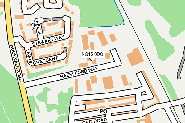
NG15 0DQ lies on Hazelford Way in Newstead Village, Nottingham. NG15 0DQ is located in the Newstead Abbey electoral ward, within the local authority district of Gedling and the English Parliamentary constituency of Sherwood. The Sub Integrated Care Board (ICB) Location is NHS Nottingham and Nottinghamshire ICB - 52R and the police force is Nottinghamshire. This postcode has been in use since January 1992.


GetTheData
Source: OS OpenMap – Local (Ordnance Survey)
Source: OS VectorMap District (Ordnance Survey)
Licence: Open Government Licence (requires attribution)
| Easting | 451902 |
| Northing | 353119 |
| Latitude | 53.072791 |
| Longitude | -1.226782 |
GetTheData
Source: Open Postcode Geo
Licence: Open Government Licence
| Street | Hazelford Way |
| Locality | Newstead Village |
| Town/City | Nottingham |
| Country | England |
| Postcode District | NG15 |
| ➜ NG15 open data dashboard ➜ See where NG15 is on a map ➜ Where is Newstead? | |
GetTheData
Source: Land Registry Price Paid Data
Licence: Open Government Licence
Elevation or altitude of NG15 0DQ as distance above sea level:
| Metres | Feet | |
|---|---|---|
| Elevation | 140m | 459ft |
Elevation is measured from the approximate centre of the postcode, to the nearest point on an OS contour line from OS Terrain 50, which has contour spacing of ten vertical metres.
➜ How high above sea level am I? Find the elevation of your current position using your device's GPS.
GetTheData
Source: Open Postcode Elevation
Licence: Open Government Licence
| Ward | Newstead Abbey |
| Constituency | Sherwood |
GetTheData
Source: ONS Postcode Database
Licence: Open Government Licence
| June 2022 | Violence and sexual offences | On or near Hazelford Way | 159m |
| June 2022 | Violence and sexual offences | On or near Tilford Road | 199m |
| June 2022 | Vehicle crime | On or near Tilford Road | 199m |
| ➜ Hazelford Way crime map and outcomes | |||
GetTheData
Source: data.police.uk
Licence: Open Government Licence
| Hazelford Way (Hucknall Road) | Newstead | 252m |
| Hazelford Way (Hucknall Road) | Newstead | 261m |
| Triangle (Hucknall Road) | Newstead | 383m |
| Triangle (Hucknall Road) | Newstead | 389m |
| Musters Road (Hucknall Road) | Newstead | 523m |
| Newstead Station | 0.5km |
| Kirkby in Ashfield Station | 3.5km |
| Hucknall Station | 4.4km |
GetTheData
Source: NaPTAN
Licence: Open Government Licence
| Median download speed | 3.2Mbps |
| Average download speed | 2.6Mbps |
| Maximum download speed | 3.89Mbps |
| Median upload speed | 1.0Mbps |
| Average upload speed | 0.9Mbps |
| Maximum upload speed | 0.99Mbps |
GetTheData
Source: Ofcom
Licence: Ofcom Terms of Use (requires attribution)
Estimated total energy consumption in NG15 0DQ by fuel type, 2015.
| Consumption (kWh) | 321,297 |
|---|---|
| Meter count | 22 |
| Mean (kWh/meter) | 14,604 |
| Median (kWh/meter) | 7,933 |
GetTheData
Source: Postcode level gas estimates: 2015 (experimental)
Source: Postcode level electricity estimates: 2015 (experimental)
Licence: Open Government Licence
GetTheData
Source: ONS Postcode Database
Licence: Open Government Licence


➜ Get more ratings from the Food Standards Agency
GetTheData
Source: Food Standards Agency
Licence: FSA terms & conditions
| Last Collection | |||
|---|---|---|---|
| Location | Mon-Fri | Sat | Distance |
| Derby Road | 16:45 | 11:30 | 1,269m |
| Newstead Abbey | 16:00 | 11:00 | 2,347m |
| Main Street | 17:00 | 12:15 | 2,615m |
GetTheData
Source: Dracos
Licence: Creative Commons Attribution-ShareAlike
| Facility | Distance |
|---|---|
| Newstead Primary & Nursery School Hucknall Road, Newstead Village, Nottingham Grass Pitches | 298m |
| Newstead Recreation Ground Tilford Road, Newstead Village, Nottingham Grass Pitches | 341m |
| Annesley Welfare (Closed) Derby Road, Annesley, Nottingham Grass Pitches | 1.2km |
GetTheData
Source: Active Places
Licence: Open Government Licence
| School | Phase of Education | Distance |
|---|---|---|
| Newstead Primary and Nursery School Hucknall Road, Newstead Village, Nottingham, NG15 0BB | Primary | 298m |
| Annesley Primary and Nursery School Forest Road, Annesley Woodhouse, Kirkby-in-Ashfield, Nottingham, NG17 9BW | Primary | 1.4km |
| Kingsway Primary School Kingsway, Kirkby-in-Ashfield, Nottingham, NG17 7FH | Primary | 2.5km |
GetTheData
Source: Edubase
Licence: Open Government Licence
The below table lists the International Territorial Level (ITL) codes (formerly Nomenclature of Territorial Units for Statistics (NUTS) codes) and Local Administrative Units (LAU) codes for NG15 0DQ:
| ITL 1 Code | Name |
|---|---|
| TLF | East Midlands (England) |
| ITL 2 Code | Name |
| TLF1 | Derbyshire and Nottinghamshire |
| ITL 3 Code | Name |
| TLF16 | South Nottinghamshire |
| LAU 1 Code | Name |
| E07000173 | Gedling |
GetTheData
Source: ONS Postcode Directory
Licence: Open Government Licence
The below table lists the Census Output Area (OA), Lower Layer Super Output Area (LSOA), and Middle Layer Super Output Area (MSOA) for NG15 0DQ:
| Code | Name | |
|---|---|---|
| OA | E00143627 | |
| LSOA | E01028189 | Gedling 001A |
| MSOA | E02005865 | Gedling 001 |
GetTheData
Source: ONS Postcode Directory
Licence: Open Government Licence
| NG15 0BX | Garden Terrace | 130m |
| NG15 0DD | Chatsworth Terrace | 152m |
| NG15 0BW | Chapel Terrace | 155m |
| NG15 0EH | Stewart Way | 161m |
| NG15 0EJ | Lewis Crescent | 164m |
| NG15 0DB | Stonehouse Terrace | 169m |
| NG15 0BU | Tilford Road | 188m |
| NG15 0EL | Pella Grove | 196m |
| NG15 0BT | Foundry Terrace | 203m |
| NG15 0BY | Tilford Road | 205m |
GetTheData
Source: Open Postcode Geo; Land Registry Price Paid Data
Licence: Open Government Licence