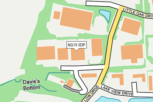
NG15 0DP lies on Willow Drive in Annesley, Nottingham. NG15 0DP is located in the Annesley & Kirkby Woodhouse electoral ward, within the local authority district of Ashfield and the English Parliamentary constituency of Ashfield. The Sub Integrated Care Board (ICB) Location is NHS Nottingham and Nottinghamshire ICB - 52R and the police force is Nottinghamshire. This postcode has been in use since June 1997.


GetTheData
Source: OS OpenMap – Local (Ordnance Survey)
Source: OS VectorMap District (Ordnance Survey)
Licence: Open Government Licence (requires attribution)
| Easting | 449667 |
| Northing | 352844 |
| Latitude | 53.070550 |
| Longitude | -1.260177 |
GetTheData
Source: Open Postcode Geo
Licence: Open Government Licence
| Street | Willow Drive |
| Locality | Annesley |
| Town/City | Nottingham |
| Country | England |
| Postcode District | NG15 |
| ➜ NG15 open data dashboard ➜ See where NG15 is on a map ➜ Where is Annesley Woodhouse? | |
GetTheData
Source: Land Registry Price Paid Data
Licence: Open Government Licence
Elevation or altitude of NG15 0DP as distance above sea level:
| Metres | Feet | |
|---|---|---|
| Elevation | 160m | 525ft |
Elevation is measured from the approximate centre of the postcode, to the nearest point on an OS contour line from OS Terrain 50, which has contour spacing of ten vertical metres.
➜ How high above sea level am I? Find the elevation of your current position using your device's GPS.
GetTheData
Source: Open Postcode Elevation
Licence: Open Government Licence
| Ward | Annesley & Kirkby Woodhouse |
| Constituency | Ashfield |
GetTheData
Source: ONS Postcode Database
Licence: Open Government Licence
| June 2022 | Theft from the person | On or near Willow Drive | 86m |
| June 2022 | Violence and sexual offences | On or near Lake View Drive | 368m |
| April 2022 | Other theft | On or near Willow Drive | 86m |
| ➜ Willow Drive crime map and outcomes | |||
GetTheData
Source: data.police.uk
Licence: Open Government Licence
| Lake View Drive (Willow Drive) | Sherwood Business Park | 77m |
| Lake View Drive (Willow Drive) | Sherwood Business Park | 90m |
| Willow Drive | Sherwood Business Park | 203m |
| Willow Drive | Sherwood Business Park | 203m |
| Willow Drive Top (Willow Drive) | Sherwood Business Park | 279m |
| Newstead Station | 2.6km |
| Kirkby in Ashfield Station | 3.3km |
| Sutton Parkway Station | 4.9km |
GetTheData
Source: NaPTAN
Licence: Open Government Licence
GetTheData
Source: ONS Postcode Database
Licence: Open Government Licence


➜ Get more ratings from the Food Standards Agency
GetTheData
Source: Food Standards Agency
Licence: FSA terms & conditions
| Last Collection | |||
|---|---|---|---|
| Location | Mon-Fri | Sat | Distance |
| Derby Road | 16:45 | 11:30 | 1,535m |
| Middlebrook Road | 16:30 | 10:30 | 2,480m |
| St Johns Avenue | 17:30 | 11:45 | 3,086m |
GetTheData
Source: Dracos
Licence: Creative Commons Attribution-ShareAlike
| Facility | Distance |
|---|---|
| Acacia Avenue Recreation Ground Acacia Avenue, Kirkby-in-ashfield, Nottingham Grass Pitches | 1.2km |
| Kirkby Woodhouse Primary School Main Road, Kirkby-in-ashfield, Nottingham Grass Pitches | 1.4km |
| Annesley Welfare (Closed) Derby Road, Annesley, Nottingham Grass Pitches | 1.4km |
GetTheData
Source: Active Places
Licence: Open Government Licence
| School | Phase of Education | Distance |
|---|---|---|
| Kirkby Woodhouse School Main Road, Kirkby-in-Ashfield, Nottingham, NG17 9EU | Primary | 1.4km |
| Annesley Primary and Nursery School Forest Road, Annesley Woodhouse, Kirkby-in-Ashfield, Nottingham, NG17 9BW | Primary | 1.5km |
| Newstead Primary and Nursery School Hucknall Road, Newstead Village, Nottingham, NG15 0BB | Primary | 2.2km |
GetTheData
Source: Edubase
Licence: Open Government Licence
The below table lists the International Territorial Level (ITL) codes (formerly Nomenclature of Territorial Units for Statistics (NUTS) codes) and Local Administrative Units (LAU) codes for NG15 0DP:
| ITL 1 Code | Name |
|---|---|
| TLF | East Midlands (England) |
| ITL 2 Code | Name |
| TLF1 | Derbyshire and Nottinghamshire |
| ITL 3 Code | Name |
| TLF15 | North Nottinghamshire |
| LAU 1 Code | Name |
| E07000170 | Ashfield |
GetTheData
Source: ONS Postcode Directory
Licence: Open Government Licence
The below table lists the Census Output Area (OA), Lower Layer Super Output Area (LSOA), and Middle Layer Super Output Area (MSOA) for NG15 0DP:
| Code | Name | |
|---|---|---|
| OA | E00142650 | |
| LSOA | E01027995 | Ashfield 010A |
| MSOA | E02005828 | Ashfield 010 |
GetTheData
Source: ONS Postcode Directory
Licence: Open Government Licence
| NG15 0HT | Lake View Drive | 362m |
| NG15 0DS | Osier Drive | 529m |
| NG17 9HB | Salmon Lane | 630m |
| NG17 9LA | Salmon Lane | 674m |
| NG17 9JA | Willow Cottages | 695m |
| NG17 9JB | Forest Road | 721m |
| NG15 0DR | Little Oak Drive | 744m |
| NG17 9HW | Forest Road | 761m |
| NG17 9HA | Forest Road | 789m |
| NG17 9JE | Skegby Road | 796m |
GetTheData
Source: Open Postcode Geo; Land Registry Price Paid Data
Licence: Open Government Licence