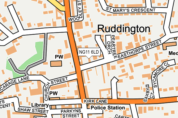
NG11 6LD lies on Widdowsons Row in Ruddington, Nottingham. NG11 6LD is located in the Ruddington electoral ward, within the local authority district of Rushcliffe and the English Parliamentary constituency of Rushcliffe. The Sub Integrated Care Board (ICB) Location is NHS Nottingham and Nottinghamshire ICB - 52R and the police force is Nottinghamshire. This postcode has been in use since January 1980.


GetTheData
Source: OS OpenMap – Local (Ordnance Survey)
Source: OS VectorMap District (Ordnance Survey)
Licence: Open Government Licence (requires attribution)
| Easting | 457354 |
| Northing | 333172 |
| Latitude | 52.892947 |
| Longitude | -1.148946 |
GetTheData
Source: Open Postcode Geo
Licence: Open Government Licence
| Street | Widdowsons Row |
| Locality | Ruddington |
| Town/City | Nottingham |
| Country | England |
| Postcode District | NG11 |
| ➜ NG11 open data dashboard ➜ See where NG11 is on a map ➜ Where is Ruddington? | |
GetTheData
Source: Land Registry Price Paid Data
Licence: Open Government Licence
Elevation or altitude of NG11 6LD as distance above sea level:
| Metres | Feet | |
|---|---|---|
| Elevation | 40m | 131ft |
Elevation is measured from the approximate centre of the postcode, to the nearest point on an OS contour line from OS Terrain 50, which has contour spacing of ten vertical metres.
➜ How high above sea level am I? Find the elevation of your current position using your device's GPS.
GetTheData
Source: Open Postcode Elevation
Licence: Open Government Licence
| Ward | Ruddington |
| Constituency | Rushcliffe |
GetTheData
Source: ONS Postcode Database
Licence: Open Government Licence
| September 2023 | Other theft | On or near Malting Close | 357m |
| June 2022 | Other theft | On or near High Street | 91m |
| June 2022 | Violence and sexual offences | On or near High Street | 91m |
| ➜ Get more crime data in our Crime section | |||
GetTheData
Source: data.police.uk
Licence: Open Government Licence
| Easthorpe Street | Ruddington | 44m |
| Easthorpe Street | Ruddington | 77m |
| Church (Church Street) | Ruddington | 111m |
| High Street | Ruddington | 121m |
| Clifton Road (Wilford Road) | Ruddington | 210m |
| Beeston Station | 5km |
GetTheData
Source: NaPTAN
Licence: Open Government Licence
| Percentage of properties with Next Generation Access | 100.0% |
| Percentage of properties with Superfast Broadband | 100.0% |
| Percentage of properties with Ultrafast Broadband | 100.0% |
| Percentage of properties with Full Fibre Broadband | 0.0% |
Superfast Broadband is between 30Mbps and 300Mbps
Ultrafast Broadband is > 300Mbps
| Percentage of properties unable to receive 2Mbps | 0.0% |
| Percentage of properties unable to receive 5Mbps | 0.0% |
| Percentage of properties unable to receive 10Mbps | 0.0% |
| Percentage of properties unable to receive 30Mbps | 0.0% |
GetTheData
Source: Ofcom
Licence: Ofcom Terms of Use (requires attribution)
GetTheData
Source: ONS Postcode Database
Licence: Open Government Licence


➜ Get more ratings from the Food Standards Agency
GetTheData
Source: Food Standards Agency
Licence: FSA terms & conditions
| Last Collection | |||
|---|---|---|---|
| Location | Mon-Fri | Sat | Distance |
| Ruddington Post Office | 17:30 | 12:00 | 99m |
| Wilford Road | 17:30 | 12:00 | 274m |
| Kirk Lane | 17:30 | 11:30 | 407m |
GetTheData
Source: Dracos
Licence: Creative Commons Attribution-ShareAlike
| Facility | Distance |
|---|---|
| Elms Park Loughborough Road, Ruddington Grass Pitches | 587m |
| Sellors Playing Field Wilford Road, Ruddington, Nottingham Grass Pitches | 610m |
| Ironworks Gym (Closed) Brookside Road, Ruddington, Nottingham Health and Fitness Gym | 711m |
GetTheData
Source: Active Places
Licence: Open Government Licence
| School | Phase of Education | Distance |
|---|---|---|
| James Peacock Infant and Nursery School Manor Park, Ruddington, Nottingham, NG11 6DS | Primary | 378m |
| Easthorpe School 165 Loughborough Road, Ruddington, Nottingham, NG11 6LQ | Not applicable | 567m |
| St Peter's CofE Junior School Ashworth Avenue, Ruddington, Nottingham, NG11 6GB | Primary | 855m |
GetTheData
Source: Edubase
Licence: Open Government Licence
The below table lists the International Territorial Level (ITL) codes (formerly Nomenclature of Territorial Units for Statistics (NUTS) codes) and Local Administrative Units (LAU) codes for NG11 6LD:
| ITL 1 Code | Name |
|---|---|
| TLF | East Midlands (England) |
| ITL 2 Code | Name |
| TLF1 | Derbyshire and Nottinghamshire |
| ITL 3 Code | Name |
| TLF16 | South Nottinghamshire |
| LAU 1 Code | Name |
| E07000176 | Rushcliffe |
GetTheData
Source: ONS Postcode Directory
Licence: Open Government Licence
The below table lists the Census Output Area (OA), Lower Layer Super Output Area (LSOA), and Middle Layer Super Output Area (MSOA) for NG11 6LD:
| Code | Name | |
|---|---|---|
| OA | E00144745 | |
| LSOA | E01028406 | Rushcliffe 011C |
| MSOA | E02005916 | Rushcliffe 011 |
GetTheData
Source: ONS Postcode Directory
Licence: Open Government Licence
| NG11 6EN | Wilford Road | 71m |
| NG11 6DT | High Street | 77m |
| NG11 6PH | Cumberland Close | 95m |
| NG11 6EL | Wilford Road | 103m |
| NG11 6HA | Church Street | 108m |
| NG11 6EH | High Street | 115m |
| NG11 6LA | Easthorpe Street | 121m |
| NG11 6LE | Easthorpe Cottages | 148m |
| NG11 6EF | Charles Street | 150m |
| NG11 6EA | High Street | 168m |
GetTheData
Source: Open Postcode Geo; Land Registry Price Paid Data
Licence: Open Government Licence