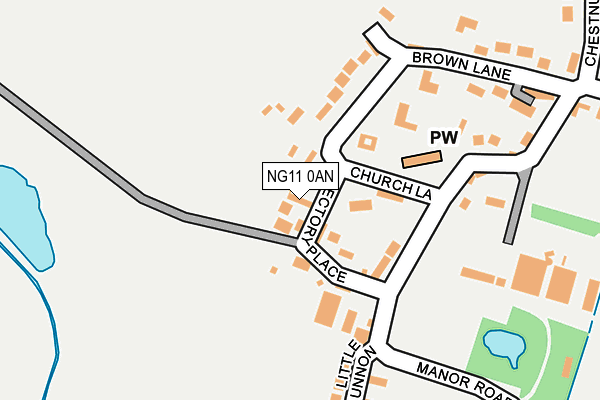
NG11 0AN lies on Old Farm Court in Barton In Fabis, Nottingham. NG11 0AN is located in the Gotham electoral ward, within the local authority district of Rushcliffe and the English Parliamentary constituency of Rushcliffe. The Sub Integrated Care Board (ICB) Location is NHS Nottingham and Nottinghamshire ICB - 52R and the police force is Nottinghamshire. This postcode has been in use since February 1990.


GetTheData
Source: OS OpenMap – Local (Ordnance Survey)
Source: OS VectorMap District (Ordnance Survey)
Licence: Open Government Licence (requires attribution)
| Easting | 452125 |
| Northing | 332718 |
| Latitude | 52.889397 |
| Longitude | -1.226734 |
GetTheData
Source: Open Postcode Geo
Licence: Open Government Licence
| Street | Old Farm Court |
| Locality | Barton In Fabis |
| Town/City | Nottingham |
| Country | England |
| Postcode District | NG11 |
➜ See where NG11 is on a map ➜ Where is Barton in Fabis? | |
GetTheData
Source: Land Registry Price Paid Data
Licence: Open Government Licence
Elevation or altitude of NG11 0AN as distance above sea level:
| Metres | Feet | |
|---|---|---|
| Elevation | 30m | 98ft |
Elevation is measured from the approximate centre of the postcode, to the nearest point on an OS contour line from OS Terrain 50, which has contour spacing of ten vertical metres.
➜ How high above sea level am I? Find the elevation of your current position using your device's GPS.
GetTheData
Source: Open Postcode Elevation
Licence: Open Government Licence
| Ward | Gotham |
| Constituency | Rushcliffe |
GetTheData
Source: ONS Postcode Database
Licence: Open Government Licence
| Rectory Place (Manor Road) | Barton In Fabis | 127m |
| Rectory Place (Manor Road) | Barton In Fabis | 136m |
| Attenborough Station | 1.9km |
| Beeston Station | 3.7km |
| East Midlands Parkway Station | 3.9km |
GetTheData
Source: NaPTAN
Licence: Open Government Licence
| Percentage of properties with Next Generation Access | 100.0% |
| Percentage of properties with Superfast Broadband | 100.0% |
| Percentage of properties with Ultrafast Broadband | 0.0% |
| Percentage of properties with Full Fibre Broadband | 0.0% |
Superfast Broadband is between 30Mbps and 300Mbps
Ultrafast Broadband is > 300Mbps
| Percentage of properties unable to receive 2Mbps | 0.0% |
| Percentage of properties unable to receive 5Mbps | 0.0% |
| Percentage of properties unable to receive 10Mbps | 0.0% |
| Percentage of properties unable to receive 30Mbps | 0.0% |
GetTheData
Source: Ofcom
Licence: Ofcom Terms of Use (requires attribution)
GetTheData
Source: ONS Postcode Database
Licence: Open Government Licence


➜ Get more ratings from the Food Standards Agency
GetTheData
Source: Food Standards Agency
Licence: FSA terms & conditions
| Last Collection | |||
|---|---|---|---|
| Location | Mon-Fri | Sat | Distance |
| Barton | 17:00 | 11:00 | 111m |
| Newbarns | 17:00 | 11:00 | 1,833m |
| Thrumpton | 17:00 | 11:00 | 1,855m |
GetTheData
Source: Dracos
Licence: Creative Commons Attribution-ShareAlike
| Risk of NG11 0AN flooding from rivers and sea | Very Low |
| ➜ NG11 0AN flood map | |
GetTheData
Source: Open Flood Risk by Postcode
Licence: Open Government Licence
The below table lists the International Territorial Level (ITL) codes (formerly Nomenclature of Territorial Units for Statistics (NUTS) codes) and Local Administrative Units (LAU) codes for NG11 0AN:
| ITL 1 Code | Name |
|---|---|
| TLF | East Midlands (England) |
| ITL 2 Code | Name |
| TLF1 | Derbyshire and Nottinghamshire |
| ITL 3 Code | Name |
| TLF16 | South Nottinghamshire |
| LAU 1 Code | Name |
| E07000176 | Rushcliffe |
GetTheData
Source: ONS Postcode Directory
Licence: Open Government Licence
The below table lists the Census Output Area (OA), Lower Layer Super Output Area (LSOA), and Middle Layer Super Output Area (MSOA) for NG11 0AN:
| Code | Name | |
|---|---|---|
| OA | E00144594 | |
| LSOA | E01028378 | Rushcliffe 014A |
| MSOA | E02005919 | Rushcliffe 014 |
GetTheData
Source: ONS Postcode Directory
Licence: Open Government Licence
| NG11 0AL | Rectory Place | 35m |
| NG11 0AG | Church Lane | 49m |
| NG11 0AA | Manor Road | 167m |
| NG11 0AD | Brown Lane | 171m |
| NG11 0AJ | Little Lunnon | 198m |
| NG11 0AF | The Limes | 255m |
| NG11 0AE | Chestnut Lane | 377m |
| NG11 0BL | Trent Side | 792m |
| NG11 0AB | Barton Lane | 910m |
| NG9 6DY | Barton Lane | 1291m |
GetTheData
Source: Open Postcode Geo; Land Registry Price Paid Data
Licence: Open Government Licence