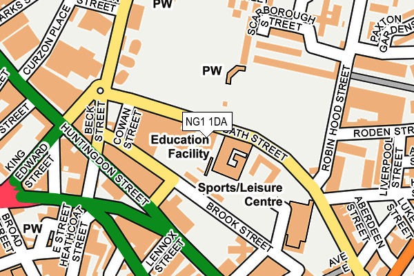
NG1 1DA is located in the St. Ann's electoral ward, within the unitary authority of Nottingham and the English Parliamentary constituency of Nottingham East. The Sub Integrated Care Board (ICB) Location is NHS Nottingham and Nottinghamshire ICB - 52R and the police force is Nottinghamshire. This postcode has been in use since January 1980.


GetTheData
Source: OS OpenMap – Local (Ordnance Survey)
Source: OS VectorMap District (Ordnance Survey)
Licence: Open Government Licence (requires attribution)
| Easting | 457848 |
| Northing | 340196 |
| Latitude | 52.956028 |
| Longitude | -1.140355 |
GetTheData
Source: Open Postcode Geo
Licence: Open Government Licence
| Country | England |
| Postcode District | NG1 |
| ➜ NG1 open data dashboard ➜ See where NG1 is on a map ➜ Where is Nottingham? | |
GetTheData
Source: Land Registry Price Paid Data
Licence: Open Government Licence
Elevation or altitude of NG1 1DA as distance above sea level:
| Metres | Feet | |
|---|---|---|
| Elevation | 40m | 131ft |
Elevation is measured from the approximate centre of the postcode, to the nearest point on an OS contour line from OS Terrain 50, which has contour spacing of ten vertical metres.
➜ How high above sea level am I? Find the elevation of your current position using your device's GPS.
GetTheData
Source: Open Postcode Elevation
Licence: Open Government Licence
| Ward | St. Ann's |
| Constituency | Nottingham East |
GetTheData
Source: ONS Postcode Database
Licence: Open Government Licence
| January 2024 | Violence and sexual offences | On or near Paxton Gardens | 327m |
| January 2024 | Violence and sexual offences | On or near Paxton Gardens | 327m |
| January 2024 | Shoplifting | On or near Shopping Area | 410m |
| ➜ Get more crime data in our Crime section | |||
GetTheData
Source: data.police.uk
Licence: Open Government Licence
| Bath Street Hr (Bath Street) | St Anns | 23m |
| Victoria Leisure Centre (Bath Street) | St Anns | 81m |
| Cowan Street (Bath Street) | St Anns | 111m |
| Cowan Street (Bath Street) | St Anns | 119m |
| Victoria Leisure Centre (Bath Street) | St Anns | 136m |
| Lace Market Tram Stop (Fletcher Gate) | Nottingham | 470m |
| Old Market Square Tram Stop (South Parade) | Nottingham | 772m |
| Royal Centre Tram Stop (Wollaton Street) | Nottingham | 795m |
| Ntu Tram Stop (Goldsmith Street) | Nottingham Trent University In City Centre | 1,056m |
| Nottingham Station Tram Stop (N/A) | Nottingham | 1,081m |
| Nottingham Station | 1.1km |
| Netherfield Station | 4.1km |
| Carlton Station | 4.3km |
GetTheData
Source: NaPTAN
Licence: Open Government Licence
GetTheData
Source: ONS Postcode Database
Licence: Open Government Licence


➜ Get more ratings from the Food Standards Agency
GetTheData
Source: Food Standards Agency
Licence: FSA terms & conditions
| Last Collection | |||
|---|---|---|---|
| Location | Mon-Fri | Sat | Distance |
| Lower Parliament Street | 19:30 | 128m | |
| City Delivery Office | 19:30 | 14:30 | 128m |
| Broad Street | 18:30 | 12:00 | 318m |
GetTheData
Source: Dracos
Licence: Creative Commons Attribution-ShareAlike
| Facility | Distance |
|---|---|
| Sutherland House School Bath Street, Nottingham Sports Hall | 31m |
| Victoria Leisure Centre (Nottingham) Gedling Street, Nottingham Sports Hall, Swimming Pool, Health and Fitness Gym, Squash Courts, Studio | 159m |
| H3 Gym Longden Street, Nottingham Health and Fitness Gym | 298m |
GetTheData
Source: Active Places
Licence: Open Government Licence
| School | Phase of Education | Distance |
|---|---|---|
| Sutherland House School Bath Street, Nottingham, NG1 1DA | Not applicable | 0m |
| Nottingham College Adams Building, Stoney Street, Nottingham, NG1 1NG | 16 plus | 426m |
| Huntingdon Academy Alfred Street Central, St Ann's, Nottingham, NG3 4AY | Primary | 646m |
GetTheData
Source: Edubase
Licence: Open Government Licence
The below table lists the International Territorial Level (ITL) codes (formerly Nomenclature of Territorial Units for Statistics (NUTS) codes) and Local Administrative Units (LAU) codes for NG1 1DA:
| ITL 1 Code | Name |
|---|---|
| TLF | East Midlands (England) |
| ITL 2 Code | Name |
| TLF1 | Derbyshire and Nottinghamshire |
| ITL 3 Code | Name |
| TLF14 | Nottingham |
| LAU 1 Code | Name |
| E06000018 | Nottingham |
GetTheData
Source: ONS Postcode Directory
Licence: Open Government Licence
The below table lists the Census Output Area (OA), Lower Layer Super Output Area (LSOA), and Middle Layer Super Output Area (MSOA) for NG1 1DA:
| Code | Name | |
|---|---|---|
| OA | E00173535 | |
| LSOA | E01033405 | Nottingham 023G |
| MSOA | E02002890 | Nottingham 023 |
GetTheData
Source: ONS Postcode Directory
Licence: Open Government Licence
| NG1 1EA | Brook Street | 75m |
| NG1 1DD | Park View Court | 96m |
| NG1 1DE | Park View Court | 96m |
| NG1 1AP | Huntingdon Street | 117m |
| NG1 1AR | Huntingdon Street | 117m |
| NG1 1AS | Huntingdon Street | 117m |
| NG1 1AT | Huntingdon Street | 117m |
| NG1 1AW | Huntingdon Street | 117m |
| NG3 1HF | Robin Hood Terrace | 155m |
| NG3 1HB | Promenade | 160m |
GetTheData
Source: Open Postcode Geo; Land Registry Price Paid Data
Licence: Open Government Licence
| Bath Street | At Any Time | 193m |
| Brook Street | At Any Time | 220m |
| Bath Street | At Any Time | 246m |
GetTheData
Source: Disabled parking spaces, Nottingham City Council, 19/02/2013
Licence: Open Government Licence