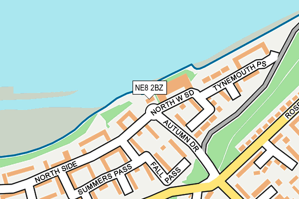
NE8 2BZ is located in the Dunston and Teams electoral ward, within the metropolitan district of Gateshead and the English Parliamentary constituency of Gateshead. The Sub Integrated Care Board (ICB) Location is NHS North East and North Cumbria ICB - 13T and the police force is Northumbria. This postcode has been in use since April 2007.


GetTheData
Source: OS OpenMap – Local (Ordnance Survey)
Source: OS VectorMap District (Ordnance Survey)
Licence: Open Government Licence (requires attribution)
| Easting | 423886 |
| Northing | 562641 |
| Latitude | 54.957847 |
| Longitude | -1.628542 |
GetTheData
Source: Open Postcode Geo
Licence: Open Government Licence
| Country | England |
| Postcode District | NE8 |
| ➜ NE8 open data dashboard ➜ See where NE8 is on a map ➜ Where is Gateshead? | |
GetTheData
Source: Land Registry Price Paid Data
Licence: Open Government Licence
Elevation or altitude of NE8 2BZ as distance above sea level:
| Metres | Feet | |
|---|---|---|
| Elevation | 0m | 0ft |
Elevation is measured from the approximate centre of the postcode, to the nearest point on an OS contour line from OS Terrain 50, which has contour spacing of ten vertical metres.
➜ How high above sea level am I? Find the elevation of your current position using your device's GPS.
GetTheData
Source: Open Postcode Elevation
Licence: Open Government Licence
| Ward | Dunston And Teams |
| Constituency | Gateshead |
GetTheData
Source: ONS Postcode Database
Licence: Open Government Licence
| December 2023 | Violence and sexual offences | On or near Fall Pass | 132m |
| November 2023 | Vehicle crime | On or near Fall Pass | 132m |
| November 2023 | Violence and sexual offences | On or near Fall Pass | 132m |
| ➜ Get more crime data in our Crime section | |||
GetTheData
Source: data.police.uk
Licence: Open Government Licence
| Team Street-gas Works (Team Street) | Teams | 192m |
| Team Street-gas Works (Team Street) | Teams | 196m |
| Rose Street | Teams | 216m |
| Yetholm Road | Teams | 235m |
| Yetholm Road | Teams | 249m |
| Central Station (Tyne And Wear Metro Station) (Neville Street) | Newcastle Upon Tyne | 1,485m |
| Dunston Station | 1.2km |
| Newcastle Station | 1.4km |
| Manors Station | 2.3km |
GetTheData
Source: NaPTAN
Licence: Open Government Licence
| Percentage of properties with Next Generation Access | 100.0% |
| Percentage of properties with Superfast Broadband | 100.0% |
| Percentage of properties with Ultrafast Broadband | 0.0% |
| Percentage of properties with Full Fibre Broadband | 0.0% |
Superfast Broadband is between 30Mbps and 300Mbps
Ultrafast Broadband is > 300Mbps
| Percentage of properties unable to receive 2Mbps | 0.0% |
| Percentage of properties unable to receive 5Mbps | 0.0% |
| Percentage of properties unable to receive 10Mbps | 0.0% |
| Percentage of properties unable to receive 30Mbps | 0.0% |
GetTheData
Source: Ofcom
Licence: Ofcom Terms of Use (requires attribution)
GetTheData
Source: ONS Postcode Database
Licence: Open Government Licence


➜ Get more ratings from the Food Standards Agency
GetTheData
Source: Food Standards Agency
Licence: FSA terms & conditions
| Last Collection | |||
|---|---|---|---|
| Location | Mon-Fri | Sat | Distance |
| Low Teams Post Office | 17:30 | 12:30 | 403m |
| Tyne Road East | 17:30 | 12:30 | 604m |
| Festival Way | 18:15 | 11:30 | 639m |
GetTheData
Source: Dracos
Licence: Creative Commons Attribution-ShareAlike
| Facility | Distance |
|---|---|
| Smith Terrace Abbeyfield Close, Gateshead Grass Pitches | 498m |
| Powerleague (Gateshead) Ropery Road, Gateshead Artificial Grass Pitch | 657m |
| Eslington Primary School (Hazel Road) Hazel Road, Gateshead Grass Pitches | 666m |
GetTheData
Source: Active Places
Licence: Open Government Licence
| School | Phase of Education | Distance |
|---|---|---|
| St Aidan's Church of England Primary School Derwentwater Road, Gateshead, NE8 2HQ | Primary | 620m |
| Eslington Primary School Hazel Road, Gateshead, NE8 2EP | Not applicable | 667m |
| St Philip Neri Catholic Primary School, Dunston Ellison Road, Dunston, Gateshead, NE8 2QU | Primary | 895m |
GetTheData
Source: Edubase
Licence: Open Government Licence
The below table lists the International Territorial Level (ITL) codes (formerly Nomenclature of Territorial Units for Statistics (NUTS) codes) and Local Administrative Units (LAU) codes for NE8 2BZ:
| ITL 1 Code | Name |
|---|---|
| TLC | North East (England) |
| ITL 2 Code | Name |
| TLC2 | Northumberland, and Tyne and Wear |
| ITL 3 Code | Name |
| TLC22 | Tyneside |
| LAU 1 Code | Name |
| E08000037 | Gateshead |
GetTheData
Source: ONS Postcode Directory
Licence: Open Government Licence
The below table lists the Census Output Area (OA), Lower Layer Super Output Area (LSOA), and Middle Layer Super Output Area (MSOA) for NE8 2BZ:
| Code | Name | |
|---|---|---|
| OA | E00166221 | |
| LSOA | E01008258 | Gateshead 007C |
| MSOA | E02001688 | Gateshead 007 |
GetTheData
Source: ONS Postcode Directory
Licence: Open Government Licence
| NE8 2BG | North West Side | 53m |
| NE8 2BF | North Side | 63m |
| NE8 2BQ | Fall Pass | 73m |
| NE8 2BW | Fall Pass | 101m |
| NE8 2BS | Christmas Place | 103m |
| NE8 2GA | North Side | 132m |
| NE8 2DL | North Side | 137m |
| NE8 2DP | Fall Pass | 138m |
| NE8 2GX | Riverside Row | 138m |
| NE8 2DZ | Summers Pass | 145m |
GetTheData
Source: Open Postcode Geo; Land Registry Price Paid Data
Licence: Open Government Licence