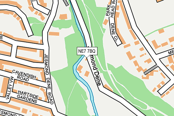
NE7 7BQ is located in the Dene & South Gosforth electoral ward, within the metropolitan district of Newcastle upon Tyne and the English Parliamentary constituency of Newcastle upon Tyne East. The Sub Integrated Care Board (ICB) Location is NHS North East and North Cumbria ICB - 13T and the police force is Northumbria. This postcode has been in use since January 1980.


GetTheData
Source: OS OpenMap – Local (Ordnance Survey)
Source: OS VectorMap District (Ordnance Survey)
Licence: Open Government Licence (requires attribution)
| Easting | 426124 |
| Northing | 566394 |
| Latitude | 54.991460 |
| Longitude | -1.593256 |
GetTheData
Source: Open Postcode Geo
Licence: Open Government Licence
| Country | England |
| Postcode District | NE7 |
➜ See where NE7 is on a map ➜ Where is Newcastle upon Tyne? | |
GetTheData
Source: Land Registry Price Paid Data
Licence: Open Government Licence
Elevation or altitude of NE7 7BQ as distance above sea level:
| Metres | Feet | |
|---|---|---|
| Elevation | 20m | 66ft |
Elevation is measured from the approximate centre of the postcode, to the nearest point on an OS contour line from OS Terrain 50, which has contour spacing of ten vertical metres.
➜ How high above sea level am I? Find the elevation of your current position using your device's GPS.
GetTheData
Source: Open Postcode Elevation
Licence: Open Government Licence
| Ward | Dene & South Gosforth |
| Constituency | Newcastle Upon Tyne East |
GetTheData
Source: ONS Postcode Database
Licence: Open Government Licence
| Cradlewell (Jesmond Road) | Jesmond | 509m |
| Cradlewell (Jesmond Road) | Jesmond | 537m |
| Newton Road-holystone Crescent (Newton Road) | High Heaton | 539m |
| Newton Road-weldon Crescent (Newton Road) | High Heaton | 553m |
| Heaton Manor Comprehensive School (Newton Road) | High Heaton | 561m |
| West Jesmond (Tyne And Wear Metro Station) (Brentwood Avenue) | West Jesmond | 1,128m |
| Jesmond (Tyne And Wear Metro Station) (Eslington Road) | Jesmond | 1,217m |
| Ilford Road (Tyne And Wear Metro Station) (Ilford Road) | West Jesmond | 1,485m |
| Chillingham Road (Tyne And Wear Metro Station) (Depot Road) | Heaton | 1,681m |
| Manors Station | 2.2km |
| Newcastle Station | 3km |
| Heworth Station | 5km |
GetTheData
Source: NaPTAN
Licence: Open Government Licence
| Percentage of properties with Next Generation Access | 100.0% |
| Percentage of properties with Superfast Broadband | 100.0% |
| Percentage of properties with Ultrafast Broadband | 0.0% |
| Percentage of properties with Full Fibre Broadband | 0.0% |
Superfast Broadband is between 30Mbps and 300Mbps
Ultrafast Broadband is > 300Mbps
| Percentage of properties unable to receive 2Mbps | 0.0% |
| Percentage of properties unable to receive 5Mbps | 0.0% |
| Percentage of properties unable to receive 10Mbps | 0.0% |
| Percentage of properties unable to receive 30Mbps | 0.0% |
GetTheData
Source: Ofcom
Licence: Ofcom Terms of Use (requires attribution)
GetTheData
Source: ONS Postcode Database
Licence: Open Government Licence


➜ Get more ratings from the Food Standards Agency
GetTheData
Source: Food Standards Agency
Licence: FSA terms & conditions
| Last Collection | |||
|---|---|---|---|
| Location | Mon-Fri | Sat | Distance |
| Jesmond Gardens | 17:45 | 11:45 | 222m |
| Jesmond Park West | 17:30 | 12:45 | 245m |
| Manor House Road | 17:45 | 11:15 | 310m |
GetTheData
Source: Dracos
Licence: Creative Commons Attribution-ShareAlike
| Risk of NE7 7BQ flooding from rivers and sea | Medium |
| ➜ NE7 7BQ flood map | |
GetTheData
Source: Open Flood Risk by Postcode
Licence: Open Government Licence
The below table lists the International Territorial Level (ITL) codes (formerly Nomenclature of Territorial Units for Statistics (NUTS) codes) and Local Administrative Units (LAU) codes for NE7 7BQ:
| ITL 1 Code | Name |
|---|---|
| TLC | North East (England) |
| ITL 2 Code | Name |
| TLC2 | Northumberland, and Tyne and Wear |
| ITL 3 Code | Name |
| TLC22 | Tyneside |
| LAU 1 Code | Name |
| E08000021 | Newcastle upon Tyne |
GetTheData
Source: ONS Postcode Directory
Licence: Open Government Licence
The below table lists the Census Output Area (OA), Lower Layer Super Output Area (LSOA), and Middle Layer Super Output Area (MSOA) for NE7 7BQ:
| Code | Name | |
|---|---|---|
| OA | E00042185 | |
| LSOA | E01008317 | Newcastle upon Tyne 007A |
| MSOA | E02001714 | Newcastle upon Tyne 007 |
GetTheData
Source: ONS Postcode Directory
Licence: Open Government Licence
| NE2 2ET | Jesmond Dene Terrace | 138m |
| NE7 7BL | Dene Close | 144m |
| NE2 2NL | Jesmond Dene Road | 151m |
| NE7 7BA | Jesmond Park Mews | 168m |
| NE2 2JT | Jesmond Dene Road | 198m |
| NE7 7DH | Park Head Road | 202m |
| NE2 2NN | Grosvenor Avenue | 208m |
| NE2 2EU | Jesmond Dene Road | 212m |
| NE7 7BU | Jesmond Park West | 221m |
| NE2 2RN | Grosvenor Road | 222m |
GetTheData
Source: Open Postcode Geo; Land Registry Price Paid Data
Licence: Open Government Licence