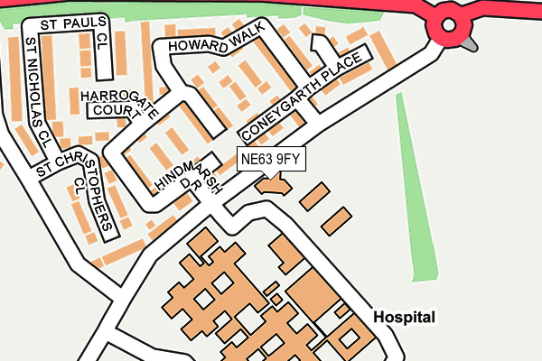
NE63 9FY is located in the Seaton with Newbiggin West electoral ward, within the unitary authority of Northumberland and the English Parliamentary constituency of Wansbeck. The Sub Integrated Care Board (ICB) Location is NHS North East and North Cumbria ICB - 00L and the police force is Northumbria. This postcode has been in use since February 2010.


GetTheData
Source: OS OpenMap – Local (Ordnance Survey)
Source: OS VectorMap District (Ordnance Survey)
Licence: Open Government Licence (requires attribution)
| Easting | 429012 |
| Northing | 588035 |
| Latitude | 55.185754 |
| Longitude | -1.545910 |
GetTheData
Source: Open Postcode Geo
Licence: Open Government Licence
| Country | England |
| Postcode District | NE63 |
| ➜ NE63 open data dashboard ➜ See where NE63 is on a map ➜ Where is Ashington? | |
GetTheData
Source: Land Registry Price Paid Data
Licence: Open Government Licence
Elevation or altitude of NE63 9FY as distance above sea level:
| Metres | Feet | |
|---|---|---|
| Elevation | 20m | 66ft |
Elevation is measured from the approximate centre of the postcode, to the nearest point on an OS contour line from OS Terrain 50, which has contour spacing of ten vertical metres.
➜ How high above sea level am I? Find the elevation of your current position using your device's GPS.
GetTheData
Source: Open Postcode Elevation
Licence: Open Government Licence
| Ward | Seaton With Newbiggin West |
| Constituency | Wansbeck |
GetTheData
Source: ONS Postcode Database
Licence: Open Government Licence
| January 2024 | Burglary | On or near Hospital | 167m |
| January 2024 | Shoplifting | On or near Hospital | 167m |
| January 2024 | Shoplifting | On or near Hospital | 167m |
| ➜ Get more crime data in our Crime section | |||
GetTheData
Source: data.police.uk
Licence: Open Government Licence
| Main Entrance (Link Road) | Wansbeck Hospital | 189m |
| St Lukes Close (A197) | Wansbeck Hospital | 226m |
| Main Entrance (Link Road) | Wansbeck Hospital | 227m |
| Woodhorn Villas (Woodhorn Lane) | Wansbeck Hospital | 328m |
| Aged Miners' Homes (A197) | Wansbeck Hospital | 346m |
GetTheData
Source: NaPTAN
Licence: Open Government Licence
GetTheData
Source: ONS Postcode Database
Licence: Open Government Licence


➜ Get more ratings from the Food Standards Agency
GetTheData
Source: Food Standards Agency
Licence: FSA terms & conditions
| Last Collection | |||
|---|---|---|---|
| Location | Mon-Fri | Sat | Distance |
| Woodhorn Villas | 17:00 | 10:45 | 554m |
| Moorhouse Estate | 17:00 | 11:45 | 622m |
| Alexandra Road | 17:00 | 11:45 | 1,111m |
GetTheData
Source: Dracos
Licence: Creative Commons Attribution-ShareAlike
| Facility | Distance |
|---|---|
| Ashington Community Football Club Woodhorn Lane, Ashington Grass Pitches | 293m |
| Hirst Welfare Centre Alexandra Road, Ashington Artificial Grass Pitch, Health and Fitness Gym, Grass Pitches, Studio | 673m |
| St Benedicts Rc Middle School (Closed) Moorhouse Lane, Ashington Sports Hall, Grass Pitches | 921m |
GetTheData
Source: Active Places
Licence: Open Government Licence
| School | Phase of Education | Distance |
|---|---|---|
| NCEA Thomas Bewick C of E Primary School Moorhouse Lane, Ashington, NE63 9LP | Primary | 785m |
| St Aidan's Catholic Primary School, Ashington Moorhouse Lane, Ashington, NE63 9LR | Primary | 910m |
| NCEA Castle School Academy Road, Ashington, NE63 9FZ | Not applicable | 1km |
GetTheData
Source: Edubase
Licence: Open Government Licence
The below table lists the International Territorial Level (ITL) codes (formerly Nomenclature of Territorial Units for Statistics (NUTS) codes) and Local Administrative Units (LAU) codes for NE63 9FY:
| ITL 1 Code | Name |
|---|---|
| TLC | North East (England) |
| ITL 2 Code | Name |
| TLC2 | Northumberland, and Tyne and Wear |
| ITL 3 Code | Name |
| TLC21 | Northumberland |
| LAU 1 Code | Name |
| E06000057 | Northumberland |
GetTheData
Source: ONS Postcode Directory
Licence: Open Government Licence
The below table lists the Census Output Area (OA), Lower Layer Super Output Area (LSOA), and Middle Layer Super Output Area (MSOA) for NE63 9FY:
| Code | Name | |
|---|---|---|
| OA | E00176343 | |
| LSOA | E01027549 | Northumberland 013E |
| MSOA | E02005736 | Northumberland 013 |
GetTheData
Source: ONS Postcode Directory
Licence: Open Government Licence
| NE63 9FQ | Marshall Close | 105m |
| NE63 9FN | Hudson Walk | 109m |
| NE63 9FH | Patterson Way | 114m |
| NE63 9FL | Coneygarth Place | 115m |
| NE63 9FA | Hindmarsh Drive | 146m |
| NE63 9FP | Howard Walk | 152m |
| NE63 9FJ | Harrogate Court | 197m |
| NE63 9DG | St Christophers Close | 214m |
| NE63 9BZ | St Pauls Close | 249m |
| NE63 9BY | St Nicholas Close | 267m |
GetTheData
Source: Open Postcode Geo; Land Registry Price Paid Data
Licence: Open Government Licence