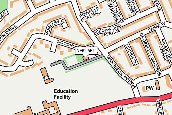
NE62 5ET is located in the Choppington electoral ward, within the unitary authority of Northumberland and the English Parliamentary constituency of Wansbeck. The Sub Integrated Care Board (ICB) Location is NHS North East and North Cumbria ICB - 00L and the police force is Northumbria. This postcode has been in use since July 2023.


GetTheData
Source: OS OpenMap – Local (Ordnance Survey)
Source: OS VectorMap District (Ordnance Survey)
Licence: Open Government Licence (requires attribution)
| Easting | 426028 |
| Northing | 585595 |
| Latitude | 55.164000 |
| Longitude | -1.593010 |
GetTheData
Source: Open Postcode Geo
Licence: Open Government Licence
| Country | England |
| Postcode District | NE62 |
| ➜ NE62 open data dashboard ➜ See where NE62 is on a map ➜ Where is Guide Post? | |
GetTheData
Source: Land Registry Price Paid Data
Licence: Open Government Licence
Elevation or altitude of NE62 5ET as distance above sea level:
| Metres | Feet | |
|---|---|---|
| Elevation | 30m | 98ft |
Elevation is measured from the approximate centre of the postcode, to the nearest point on an OS contour line from OS Terrain 50, which has contour spacing of ten vertical metres.
➜ How high above sea level am I? Find the elevation of your current position using your device's GPS.
GetTheData
Source: Open Postcode Elevation
Licence: Open Government Licence
| Ward | Choppington |
| Constituency | Wansbeck |
GetTheData
Source: ONS Postcode Database
Licence: Open Government Licence
| January 2024 | Anti-social behaviour | On or near Woodhorn Drive | 59m |
| January 2024 | Burglary | On or near Woodhorn Drive | 59m |
| December 2023 | Violence and sexual offences | On or near Mitford Gardens | 293m |
| ➜ Get more crime data in our Crime section | |||
GetTheData
Source: data.police.uk
Licence: Open Government Licence
| Mitford Gardens (Ashington Drive) | Wansbeck Estate | 176m |
| Mitford Gardens (Ashington Drive) | Wansbeck Estate | 179m |
| Middle School (Stakeford Lane) | Guide Post | 222m |
| Middle School (Stakeford Lane) | Guide Post | 233m |
| Glendale Avenue (Ashington Drive) | Wansbeck Estate | 291m |
| Pegswood Station | 3.6km |
GetTheData
Source: NaPTAN
Licence: Open Government Licence
GetTheData
Source: ONS Postcode Database
Licence: Open Government Licence


➜ Get more ratings from the Food Standards Agency
GetTheData
Source: Food Standards Agency
Licence: FSA terms & conditions
| Last Collection | |||
|---|---|---|---|
| Location | Mon-Fri | Sat | Distance |
| Stakeford Terrace | 16:15 | 11:00 | 355m |
| Coleridge Drive | 16:15 | 11:00 | 382m |
| Sheepwash Bank | 16:00 | 11:15 | 667m |
GetTheData
Source: Dracos
Licence: Creative Commons Attribution-ShareAlike
| Facility | Distance |
|---|---|
| Mowbray Primary School Stakeford Lane, Choppington Grass Pitches | 234m |
| Guide Post Middle School (Closed) Stakeford Lane, Choppington Sports Hall, Grass Pitches | 356m |
| Cleaswell Hill Park Sheepwash Bank, Guide Post Grass Pitches | 437m |
GetTheData
Source: Active Places
Licence: Open Government Licence
| School | Phase of Education | Distance |
|---|---|---|
| Mowbray Primary School Stakeford Lane, Guide Post, Choppington, NE62 5HQ | Primary | 268m |
| Cleaswell Hill School School Avenue, Guide Post, Choppington, NE62 5DJ | Not applicable | 354m |
| Ringway Primary School Ringway, Guide Post, Choppington, NE62 5YP | Primary | 404m |
GetTheData
Source: Edubase
Licence: Open Government Licence
The below table lists the International Territorial Level (ITL) codes (formerly Nomenclature of Territorial Units for Statistics (NUTS) codes) and Local Administrative Units (LAU) codes for NE62 5ET:
| ITL 1 Code | Name |
|---|---|
| TLC | North East (England) |
| ITL 2 Code | Name |
| TLC2 | Northumberland, and Tyne and Wear |
| ITL 3 Code | Name |
| TLC21 | Northumberland |
| LAU 1 Code | Name |
| E06000057 | Northumberland |
GetTheData
Source: ONS Postcode Directory
Licence: Open Government Licence
The below table lists the Census Output Area (OA), Lower Layer Super Output Area (LSOA), and Middle Layer Super Output Area (MSOA) for NE62 5ET:
| Code | Name | |
|---|---|---|
| OA | E00140148 | |
| LSOA | E01027534 | Northumberland 017C |
| MSOA | E02005739 | Northumberland 017 |
GetTheData
Source: ONS Postcode Directory
Licence: Open Government Licence
| NE62 5ES | Woodhorn Drive | 0m |
| NE62 5ER | Horsley Close | 86m |
| NE62 5EZ | Wansbeck Avenue | 92m |
| NE62 5EY | Wansbeck Avenue | 121m |
| NE62 5EP | Woodhorn Drive | 122m |
| NE62 5AB | Ashington Drive | 147m |
| NE62 5HA | Bowfell Gardens | 162m |
| NE62 5XS | Ashington Drive | 186m |
| NE62 5AD | Ashington Drive | 191m |
| NE62 5AE | Ashington Drive | 194m |
GetTheData
Source: Open Postcode Geo; Land Registry Price Paid Data
Licence: Open Government Licence