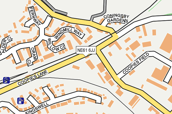
NE61 6JJ is located in the Morpeth Stobhill electoral ward, within the unitary authority of Northumberland and the English Parliamentary constituency of Wansbeck. The Sub Integrated Care Board (ICB) Location is NHS North East and North Cumbria ICB - 00L and the police force is Northumbria. This postcode has been in use since January 1980.


GetTheData
Source: OS OpenMap – Local (Ordnance Survey)
Source: OS VectorMap District (Ordnance Survey)
Licence: Open Government Licence (requires attribution)
| Easting | 420757 |
| Northing | 585543 |
| Latitude | 55.163775 |
| Longitude | -1.675733 |
GetTheData
Source: Open Postcode Geo
Licence: Open Government Licence
| Country | England |
| Postcode District | NE61 |
| ➜ NE61 open data dashboard ➜ See where NE61 is on a map ➜ Where is Morpeth? | |
GetTheData
Source: Land Registry Price Paid Data
Licence: Open Government Licence
Elevation or altitude of NE61 6JJ as distance above sea level:
| Metres | Feet | |
|---|---|---|
| Elevation | 50m | 164ft |
Elevation is measured from the approximate centre of the postcode, to the nearest point on an OS contour line from OS Terrain 50, which has contour spacing of ten vertical metres.
➜ How high above sea level am I? Find the elevation of your current position using your device's GPS.
GetTheData
Source: Open Postcode Elevation
Licence: Open Government Licence
| Ward | Morpeth Stobhill |
| Constituency | Wansbeck |
GetTheData
Source: ONS Postcode Database
Licence: Open Government Licence
| September 2023 | Anti-social behaviour | On or near Bankside | 371m |
| June 2022 | Vehicle crime | On or near Fernway | 231m |
| June 2022 | Vehicle crime | On or near Fernway | 231m |
| ➜ Get more crime data in our Crime section | |||
GetTheData
Source: data.police.uk
Licence: Open Government Licence
| Railway Station Entrance (Coopies Lane) | Morpeth | 454m |
| Railway Station (Shields Road) | Morpeth | 517m |
| Shields Road | Stobhillgate | 529m |
| Shields Road | Stobhillgate | 555m |
| Railway Station (Shields Road) | Morpeth | 568m |
| Morpeth Station | 0.5km |
| Pegswood Station | 2.6km |
GetTheData
Source: NaPTAN
Licence: Open Government Licence
GetTheData
Source: ONS Postcode Database
Licence: Open Government Licence


➜ Get more ratings from the Food Standards Agency
GetTheData
Source: Food Standards Agency
Licence: FSA terms & conditions
| Last Collection | |||
|---|---|---|---|
| Location | Mon-Fri | Sat | Distance |
| Coopies Lane | 18:30 | 11:45 | 218m |
| Railway Station | 17:30 | 11:45 | 476m |
| Green Lane | 16:45 | 12:00 | 654m |
GetTheData
Source: Dracos
Licence: Creative Commons Attribution-ShareAlike
| Facility | Distance |
|---|---|
| Morpeth Stobhillgate First School Morpeth Grass Pitches | 476m |
| Collingwood School And Media Arts College Morpeth Swimming Pool, Grass Pitches | 535m |
| Lifespan (Ladies Only)(Morpeth) (Closed) Castle Bank, Morpeth Studio, Health and Fitness Gym | 627m |
GetTheData
Source: Active Places
Licence: Open Government Licence
| School | Phase of Education | Distance |
|---|---|---|
| Morpeth Stobhillgate First School Stobhillgate, Morpeth, NE61 2HA | Primary | 476m |
| Collingwood School & Media Arts College Stobhillgate, Morpeth, NE61 2HA | Not applicable | 535m |
| St Roberts Catholic First School, Morpeth Oldgate, Morpeth, NE61 1QF | Primary | 1.2km |
GetTheData
Source: Edubase
Licence: Open Government Licence
The below table lists the International Territorial Level (ITL) codes (formerly Nomenclature of Territorial Units for Statistics (NUTS) codes) and Local Administrative Units (LAU) codes for NE61 6JJ:
| ITL 1 Code | Name |
|---|---|
| TLC | North East (England) |
| ITL 2 Code | Name |
| TLC2 | Northumberland, and Tyne and Wear |
| ITL 3 Code | Name |
| TLC21 | Northumberland |
| LAU 1 Code | Name |
| E06000057 | Northumberland |
GetTheData
Source: ONS Postcode Directory
Licence: Open Government Licence
The below table lists the Census Output Area (OA), Lower Layer Super Output Area (LSOA), and Middle Layer Super Output Area (MSOA) for NE61 6JJ:
| Code | Name | |
|---|---|---|
| OA | E00139727 | |
| LSOA | E01027452 | Northumberland 016A |
| MSOA | E02005723 | Northumberland 016 |
GetTheData
Source: ONS Postcode Directory
Licence: Open Government Licence
| NE61 1XG | Willow Close | 95m |
| NE61 1XQ | Windmill Way | 102m |
| NE61 6JX | North Level Crossing | 106m |
| NE61 1XF | Oram Close | 161m |
| NE61 2TZ | Kingswell | 172m |
| NE61 6JD | Coningsby Gardens | 174m |
| NE61 1UX | Salisbury Street | 177m |
| NE61 2EX | Sixth Avenue | 204m |
| NE61 1UY | Kensington Cottages | 217m |
| NE61 1XE | Orchard Close | 225m |
GetTheData
Source: Open Postcode Geo; Land Registry Price Paid Data
Licence: Open Government Licence