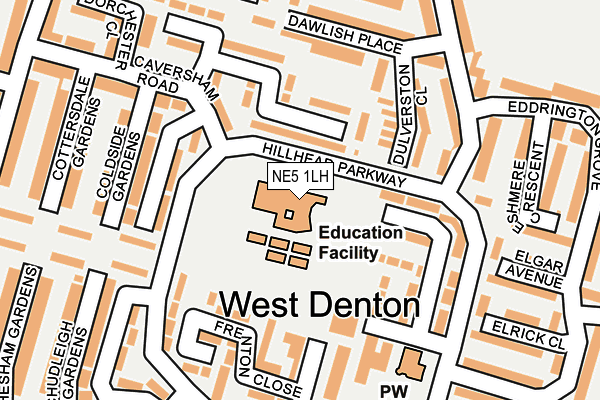
NE5 1LH is located in the Chapel electoral ward, within the metropolitan district of Newcastle upon Tyne and the English Parliamentary constituency of Newcastle upon Tyne North. The Sub Integrated Care Board (ICB) Location is NHS North East and North Cumbria ICB - 13T and the police force is Northumbria. This postcode has been in use since January 1980.


GetTheData
Source: OS OpenMap – Local (Ordnance Survey)
Source: OS VectorMap District (Ordnance Survey)
Licence: Open Government Licence (requires attribution)
| Easting | 418165 |
| Northing | 567015 |
| Latitude | 54.997392 |
| Longitude | -1.717606 |
GetTheData
Source: Open Postcode Geo
Licence: Open Government Licence
| Country | England |
| Postcode District | NE5 |
| ➜ NE5 open data dashboard ➜ See where NE5 is on a map ➜ Where is Newcastle upon Tyne? | |
GetTheData
Source: Land Registry Price Paid Data
Licence: Open Government Licence
Elevation or altitude of NE5 1LH as distance above sea level:
| Metres | Feet | |
|---|---|---|
| Elevation | 110m | 361ft |
Elevation is measured from the approximate centre of the postcode, to the nearest point on an OS contour line from OS Terrain 50, which has contour spacing of ten vertical metres.
➜ How high above sea level am I? Find the elevation of your current position using your device's GPS.
GetTheData
Source: Open Postcode Elevation
Licence: Open Government Licence
| Ward | Chapel |
| Constituency | Newcastle Upon Tyne North |
GetTheData
Source: ONS Postcode Database
Licence: Open Government Licence
| June 2022 | Criminal damage and arson | On or near Dulverston Close | 140m |
| June 2022 | Criminal damage and arson | On or near Dulverston Close | 140m |
| June 2022 | Public order | On or near Shopping Area | 234m |
| ➜ Get more crime data in our Crime section | |||
GetTheData
Source: data.police.uk
Licence: Open Government Licence
| Knoplaw First School (Hillhead Parkway) | Chapel House | 33m |
| Hillhead Parkway-terminus (Hillhead Parkway) | Chapel House | 91m |
| Hillhead Parkway | Chapel House | 219m |
| Hillhead Parkway-elston Close (Hillhead Parkway) | Chapel House | 267m |
| Chapel House Annex (Hillhead Parkway) | Chapel House | 268m |
| Blaydon Station | 3.5km |
| Newcastle Airport Metro | 4.3km |
| Metrocentre Station | 5.4km |
GetTheData
Source: NaPTAN
Licence: Open Government Licence
GetTheData
Source: ONS Postcode Database
Licence: Open Government Licence


➜ Get more ratings from the Food Standards Agency
GetTheData
Source: Food Standards Agency
Licence: FSA terms & conditions
| Last Collection | |||
|---|---|---|---|
| Location | Mon-Fri | Sat | Distance |
| Chapel House Post Office | 17:45 | 12:15 | 250m |
| Chapel House Drive | 17:30 | 11:00 | 570m |
| Grosvenor Way | 16:00 | 11:00 | 818m |
GetTheData
Source: Dracos
Licence: Creative Commons Attribution-ShareAlike
| Facility | Distance |
|---|---|
| Chapel Park Middle School (Closed) Granville Drive, Chapel Park, Newcastle Upon Tyne Grass Pitches | 374m |
| St. John Vianney Rc Primary School Hillhead Road, Newcastle Upon Tyne Grass Pitches | 771m |
| West Denton Indoor Bowls Club Hillhead Road, Newcastle Upon Tyne Indoor Bowls | 825m |
GetTheData
Source: Active Places
Licence: Open Government Licence
| School | Phase of Education | Distance |
|---|---|---|
| Milecastle Primary School Hillhead Parkway, Chapel House, Newcastle-upon-Tyne, NE5 1LH | Primary | 42m |
| Knop Law Primary School Hillhead Parkway, Chapel House, Newcastle-upon-Tyne, NE5 1DS | Primary | 359m |
| St John Vianney Catholic Primary School, West Denton Hillhead Road, West Denton, Newcastle-upon-Tyne, NE5 1DN | Primary | 768m |
GetTheData
Source: Edubase
Licence: Open Government Licence
The below table lists the International Territorial Level (ITL) codes (formerly Nomenclature of Territorial Units for Statistics (NUTS) codes) and Local Administrative Units (LAU) codes for NE5 1LH:
| ITL 1 Code | Name |
|---|---|
| TLC | North East (England) |
| ITL 2 Code | Name |
| TLC2 | Northumberland, and Tyne and Wear |
| ITL 3 Code | Name |
| TLC22 | Tyneside |
| LAU 1 Code | Name |
| E08000021 | Newcastle upon Tyne |
GetTheData
Source: ONS Postcode Directory
Licence: Open Government Licence
The below table lists the Census Output Area (OA), Lower Layer Super Output Area (LSOA), and Middle Layer Super Output Area (MSOA) for NE5 1LH:
| Code | Name | |
|---|---|---|
| OA | E00042854 | |
| LSOA | E01008447 | Newcastle upon Tyne 031F |
| MSOA | E02006893 | Newcastle upon Tyne 031 |
GetTheData
Source: ONS Postcode Directory
Licence: Open Government Licence
| NE5 1JY | Hillhead Parkway | 63m |
| NE5 1EF | Hanover Walk | 112m |
| NE5 1LE | Dickens Walk | 118m |
| NE5 1JD | Denham Walk | 122m |
| NE5 1LD | Dulverston Close | 124m |
| NE5 1EG | Hanover Close | 125m |
| NE5 1JX | Hillhead Parkway | 132m |
| NE5 1EH | Frenton Close | 160m |
| NE5 1JS | Coldside Gardens | 164m |
| NE5 1EW | Hillhead Parkway | 167m |
GetTheData
Source: Open Postcode Geo; Land Registry Price Paid Data
Licence: Open Government Licence