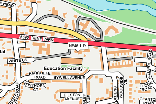
NE46 1UY is located in the Hexham East electoral ward, within the unitary authority of Northumberland and the English Parliamentary constituency of Hexham. The Sub Integrated Care Board (ICB) Location is NHS North East and North Cumbria ICB - 00L and the police force is Northumbria. This postcode has been in use since December 1994.


GetTheData
Source: OS OpenMap – Local (Ordnance Survey)
Source: OS VectorMap District (Ordnance Survey)
Licence: Open Government Licence (requires attribution)
| Easting | 394557 |
| Northing | 563885 |
| Latitude | 54.969561 |
| Longitude | -2.086562 |
GetTheData
Source: Open Postcode Geo
Licence: Open Government Licence
| Country | England |
| Postcode District | NE46 |
| ➜ NE46 open data dashboard ➜ See where NE46 is on a map ➜ Where is Hexham? | |
GetTheData
Source: Land Registry Price Paid Data
Licence: Open Government Licence
Elevation or altitude of NE46 1UY as distance above sea level:
| Metres | Feet | |
|---|---|---|
| Elevation | 50m | 164ft |
Elevation is measured from the approximate centre of the postcode, to the nearest point on an OS contour line from OS Terrain 50, which has contour spacing of ten vertical metres.
➜ How high above sea level am I? Find the elevation of your current position using your device's GPS.
GetTheData
Source: Open Postcode Elevation
Licence: Open Government Licence
| Ward | Hexham East |
| Constituency | Hexham |
GetTheData
Source: ONS Postcode Database
Licence: Open Government Licence
| June 2022 | Criminal damage and arson | On or near Dene Park | 136m |
| June 2022 | Violence and sexual offences | On or near Springfield Road | 352m |
| June 2022 | Burglary | On or near Hillcrest Drive | 400m |
| ➜ Get more crime data in our Crime section | |||
GetTheData
Source: data.police.uk
Licence: Open Government Licence
| Woodlands (A695) | Hexham | 57m |
| Woodlands (A695) | Hexham | 127m |
| Dean View House (A695) | Hexham | 187m |
| General Hospital (A695) | Hexham | 343m |
| General Hospital East Entrance (Approach Road) | Hexham | 378m |
| Hexham Station | 0.7km |
| Corbridge Station | 4.4km |
GetTheData
Source: NaPTAN
Licence: Open Government Licence
GetTheData
Source: ONS Postcode Database
Licence: Open Government Licence


➜ Get more ratings from the Food Standards Agency
GetTheData
Source: Food Standards Agency
Licence: FSA terms & conditions
| Last Collection | |||
|---|---|---|---|
| Location | Mon-Fri | Sat | Distance |
| Corbridge Road | 16:45 | 12:15 | 84m |
| Maidens Walk | 16:30 | 12:15 | 371m |
| Dean Street | 17:15 | 12:00 | 449m |
GetTheData
Source: Dracos
Licence: Creative Commons Attribution-ShareAlike
| Facility | Distance |
|---|---|
| Hexham Priory School Corbridge Road, Hexham Grass Pitches | 43m |
| Hexham First School Beaufront Avenue, Hexham Grass Pitches | 283m |
| Hexham Middle School (Closed) Wanless Lane, Hexham Grass Pitches, Sports Hall | 731m |
GetTheData
Source: Active Places
Licence: Open Government Licence
| School | Phase of Education | Distance |
|---|---|---|
| Hexham Priory School Corbridge Road, Hexham, NE46 1UY | Not applicable | 45m |
| Hexham First School Beaufront Avenue, Hexham, NE46 1JD | Primary | 288m |
| Hexham Middle School Whetstone Bridge Road, Hexham, NE46 3JB | Middle deemed secondary | 821m |
GetTheData
Source: Edubase
Licence: Open Government Licence
The below table lists the International Territorial Level (ITL) codes (formerly Nomenclature of Territorial Units for Statistics (NUTS) codes) and Local Administrative Units (LAU) codes for NE46 1UY:
| ITL 1 Code | Name |
|---|---|
| TLC | North East (England) |
| ITL 2 Code | Name |
| TLC2 | Northumberland, and Tyne and Wear |
| ITL 3 Code | Name |
| TLC21 | Northumberland |
| LAU 1 Code | Name |
| E06000057 | Northumberland |
GetTheData
Source: ONS Postcode Directory
Licence: Open Government Licence
The below table lists the Census Output Area (OA), Lower Layer Super Output Area (LSOA), and Middle Layer Super Output Area (MSOA) for NE46 1UY:
| Code | Name | |
|---|---|---|
| OA | E00139936 | |
| LSOA | E01027493 | Northumberland 035F |
| MSOA | E02005730 | Northumberland 035 |
GetTheData
Source: ONS Postcode Directory
Licence: Open Government Licence
| NE46 1HR | Woodlands | 73m |
| NE46 1JA | Bywell Avenue | 88m |
| NE46 1HS | Monks Terrace | 99m |
| NE46 1HW | 117m | |
| NE46 1HZ | Hudshaw | 142m |
| NE46 1HN | Dene Park | 145m |
| NE46 1HT | Woodlands | 152m |
| NE46 1JE | Dilston Avenue | 158m |
| NE46 1HU | Woodside | 174m |
| NE46 1JB | Langley Avenue | 176m |
GetTheData
Source: Open Postcode Geo; Land Registry Price Paid Data
Licence: Open Government Licence