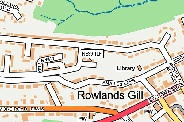
NE39 1LF is located in the Chopwell and Rowlands Gill electoral ward, within the metropolitan district of Gateshead and the English Parliamentary constituency of Blaydon. The Sub Integrated Care Board (ICB) Location is NHS North East and North Cumbria ICB - 13T and the police force is Northumbria. This postcode has been in use since January 1980.


GetTheData
Source: OS OpenMap – Local (Ordnance Survey)
Source: OS VectorMap District (Ordnance Survey)
Licence: Open Government Licence (requires attribution)
| Easting | 416244 |
| Northing | 558440 |
| Latitude | 54.920403 |
| Longitude | -1.748112 |
GetTheData
Source: Open Postcode Geo
Licence: Open Government Licence
| Country | England |
| Postcode District | NE39 |
| ➜ NE39 open data dashboard ➜ See where NE39 is on a map ➜ Where is Rowlands Gill? | |
GetTheData
Source: Land Registry Price Paid Data
Licence: Open Government Licence
Elevation or altitude of NE39 1LF as distance above sea level:
| Metres | Feet | |
|---|---|---|
| Elevation | 70m | 230ft |
Elevation is measured from the approximate centre of the postcode, to the nearest point on an OS contour line from OS Terrain 50, which has contour spacing of ten vertical metres.
➜ How high above sea level am I? Find the elevation of your current position using your device's GPS.
GetTheData
Source: Open Postcode Elevation
Licence: Open Government Licence
| Ward | Chopwell And Rowlands Gill |
| Constituency | Blaydon |
GetTheData
Source: ONS Postcode Database
Licence: Open Government Licence
| June 2022 | Anti-social behaviour | On or near Strathmore Road | 225m |
| June 2022 | Violence and sexual offences | On or near Derwent Avenue | 247m |
| June 2022 | Violence and sexual offences | On or near Supermarket | 284m |
| ➜ Get more crime data in our Crime section | |||
GetTheData
Source: data.police.uk
Licence: Open Government Licence
| Station Road - Stirling Lane (Station Road) | Rowlands Gill | 222m |
| Stirling Lane | Rowlands Gill | 260m |
| Stathmore Road | Rowlands Gill | 330m |
| Station Road - The Grove (Station Road) | Rowlands Gill | 330m |
| Strathmore Road | Rowlands Gill | 335m |
GetTheData
Source: NaPTAN
Licence: Open Government Licence
| Percentage of properties with Next Generation Access | 100.0% |
| Percentage of properties with Superfast Broadband | 100.0% |
| Percentage of properties with Ultrafast Broadband | 0.0% |
| Percentage of properties with Full Fibre Broadband | 0.0% |
Superfast Broadband is between 30Mbps and 300Mbps
Ultrafast Broadband is > 300Mbps
| Percentage of properties unable to receive 2Mbps | 0.0% |
| Percentage of properties unable to receive 5Mbps | 0.0% |
| Percentage of properties unable to receive 10Mbps | 0.0% |
| Percentage of properties unable to receive 30Mbps | 0.0% |
GetTheData
Source: Ofcom
Licence: Ofcom Terms of Use (requires attribution)
GetTheData
Source: ONS Postcode Database
Licence: Open Government Licence

➜ Get more ratings from the Food Standards Agency
GetTheData
Source: Food Standards Agency
Licence: FSA terms & conditions
| Last Collection | |||
|---|---|---|---|
| Location | Mon-Fri | Sat | Distance |
| Smailes Lane | 17:00 | 10:30 | 108m |
| Rowlands Gill Post Office | 17:15 | 12:00 | 354m |
| Strathmore Road | 16:45 | 10:30 | 379m |
GetTheData
Source: Dracos
Licence: Creative Commons Attribution-ShareAlike
| Facility | Distance |
|---|---|
| G-fit Studio Dipwood Road, Rowlands Gill Health and Fitness Gym, Studio | 209m |
| Derwent Park Burnopfield Road, Rowlands Gill Outdoor Tennis Courts, Grass Pitches | 566m |
| Highfield Community And St Josephs Rc Schools Whinfield Way, Rowlands Gill Sports Hall, Grass Pitches | 682m |
GetTheData
Source: Active Places
Licence: Open Government Licence
| School | Phase of Education | Distance |
|---|---|---|
| Highfield Community Primary School Whinfield Way, Rowlands Gill, NE39 2JE | Primary | 689m |
| St Joseph's Roman Catholic Voluntary Aided Primary School, Highfield Whinfield Way, Highfield, Rowlands Gill, NE39 2JE | Primary | 689m |
| Rowlands Gill Community Primary School Dominines Close, Rowlands Gill, NE39 2PP | Primary | 768m |
GetTheData
Source: Edubase
Licence: Open Government Licence
The below table lists the International Territorial Level (ITL) codes (formerly Nomenclature of Territorial Units for Statistics (NUTS) codes) and Local Administrative Units (LAU) codes for NE39 1LF:
| ITL 1 Code | Name |
|---|---|
| TLC | North East (England) |
| ITL 2 Code | Name |
| TLC2 | Northumberland, and Tyne and Wear |
| ITL 3 Code | Name |
| TLC22 | Tyneside |
| LAU 1 Code | Name |
| E08000037 | Gateshead |
GetTheData
Source: ONS Postcode Directory
Licence: Open Government Licence
The below table lists the Census Output Area (OA), Lower Layer Super Output Area (LSOA), and Middle Layer Super Output Area (MSOA) for NE39 1LF:
| Code | Name | |
|---|---|---|
| OA | E00041496 | |
| LSOA | E01008185 | Gateshead 022B |
| MSOA | E02001703 | Gateshead 022 |
GetTheData
Source: ONS Postcode Directory
Licence: Open Government Licence
| NE39 1JG | Smailes Lane | 61m |
| NE39 1LE | South Sherburn | 114m |
| NE39 1JF | Smailes Lane | 120m |
| NE39 1HX | Strathmore Road | 121m |
| NE39 1JX | South Sherburn | 148m |
| NE39 1HY | Strathmore Avenue | 151m |
| NE39 1BY | Dipwood Road | 196m |
| NE39 1JT | Norman Road | 201m |
| NE39 1JY | South Sherburn | 203m |
| NE39 1JQ | Smailes Lane | 207m |
GetTheData
Source: Open Postcode Geo; Land Registry Price Paid Data
Licence: Open Government Licence