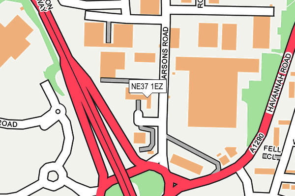
NE37 1EZ lies on Parsons Road in Washington. NE37 1EZ is located in the Washington West electoral ward, within the metropolitan district of Sunderland and the English Parliamentary constituency of Washington and Sunderland West. The Sub Integrated Care Board (ICB) Location is NHS North East and North Cumbria ICB - 00P and the police force is Northumbria. This postcode has been in use since January 1993.


GetTheData
Source: OS OpenMap – Local (Ordnance Survey)
Source: OS VectorMap District (Ordnance Survey)
Licence: Open Government Licence (requires attribution)
| Easting | 429504 |
| Northing | 557377 |
| Latitude | 54.910239 |
| Longitude | -1.541341 |
GetTheData
Source: Open Postcode Geo
Licence: Open Government Licence
| Street | Parsons Road |
| Town/City | Washington |
| Country | England |
| Postcode District | NE37 |
| ➜ NE37 open data dashboard ➜ See where NE37 is on a map ➜ Where is Washington? | |
GetTheData
Source: Land Registry Price Paid Data
Licence: Open Government Licence
Elevation or altitude of NE37 1EZ as distance above sea level:
| Metres | Feet | |
|---|---|---|
| Elevation | 90m | 295ft |
Elevation is measured from the approximate centre of the postcode, to the nearest point on an OS contour line from OS Terrain 50, which has contour spacing of ten vertical metres.
➜ How high above sea level am I? Find the elevation of your current position using your device's GPS.
GetTheData
Source: Open Postcode Elevation
Licence: Open Government Licence
| Ward | Washington West |
| Constituency | Washington And Sunderland West |
GetTheData
Source: ONS Postcode Database
Licence: Open Government Licence
| June 2022 | Other theft | On or near Petrol Station | 203m |
| June 2022 | Shoplifting | On or near Petrol Station | 203m |
| June 2022 | Burglary | On or near Blue House Court | 388m |
| ➜ Parsons Road crime map and outcomes | |||
GetTheData
Source: data.police.uk
Licence: Open Government Licence
| Parsons (Parsons Road) | Albany | 27m |
| Parsons (Parsons Road) | Albany | 50m |
| Washington Highway-industrial Estate (Washington Highway) | Armstrong | 103m |
| Washington Highway-industrial Estate (Washington Highway) | Armstrong | 148m |
| Armstrong Road (Access Road) | Armstrong | 199m |
| Heworth Station | 4.7km |
GetTheData
Source: NaPTAN
Licence: Open Government Licence
GetTheData
Source: ONS Postcode Database
Licence: Open Government Licence


➜ Get more ratings from the Food Standards Agency
GetTheData
Source: Food Standards Agency
Licence: FSA terms & conditions
| Last Collection | |||
|---|---|---|---|
| Location | Mon-Fri | Sat | Distance |
| Parsons Road | 16:30 | 12:00 | 170m |
| Brandy Row | 17:00 | 12:00 | 335m |
| Donvale Road | 17:15 | 10:00 | 513m |
GetTheData
Source: Dracos
Licence: Creative Commons Attribution-ShareAlike
| Facility | Distance |
|---|---|
| Albany Village Primary School Crossgill, Washington Grass Pitches | 564m |
| George Washington Primary School Well Bank Road, Washington Swimming Pool, Sports Hall, Grass Pitches | 945m |
| Washington Academy Spout Lane, Washington Health and Fitness Gym, Sports Hall, Grass Pitches, Studio, Outdoor Tennis Courts | 1.2km |
GetTheData
Source: Active Places
Licence: Open Government Licence
| School | Phase of Education | Distance |
|---|---|---|
| Albany Village Primary School Crossgill, Albany, Washington, NE37 1UA | Primary | 523m |
| Blackfell Primary School Knoulberry, Blackfell, Washington, NE37 1HA | Primary | 856m |
| George Washington Primary School Well Bank Road, Washington, NE37 1NL | Primary | 911m |
GetTheData
Source: Edubase
Licence: Open Government Licence
The below table lists the International Territorial Level (ITL) codes (formerly Nomenclature of Territorial Units for Statistics (NUTS) codes) and Local Administrative Units (LAU) codes for NE37 1EZ:
| ITL 1 Code | Name |
|---|---|
| TLC | North East (England) |
| ITL 2 Code | Name |
| TLC2 | Northumberland, and Tyne and Wear |
| ITL 3 Code | Name |
| TLC23 | Sunderland |
| LAU 1 Code | Name |
| E08000024 | Sunderland |
GetTheData
Source: ONS Postcode Directory
Licence: Open Government Licence
The below table lists the Census Output Area (OA), Lower Layer Super Output Area (LSOA), and Middle Layer Super Output Area (MSOA) for NE37 1EZ:
| Code | Name | |
|---|---|---|
| OA | E00045052 | |
| LSOA | E01008879 | Sunderland 010D |
| MSOA | E02001800 | Sunderland 010 |
GetTheData
Source: ONS Postcode Directory
Licence: Open Government Licence
| NE37 1ET | Rosse Close | 251m |
| NE37 1HB | Parsons Road | 258m |
| NE37 1AT | Fell Close | 271m |
| NE37 1AX | Fell Close | 280m |
| NE37 1AR | Fell Close | 292m |
| NE37 1GA | Grousemoor | 308m |
| NE37 1TH | Mardale | 321m |
| NE37 1AW | Brackenway | 330m |
| NE37 1AU | Whinway | 353m |
| NE37 1GB | Pheasantmoor | 358m |
GetTheData
Source: Open Postcode Geo; Land Registry Price Paid Data
Licence: Open Government Licence