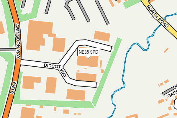
NE35 9PD is located in the Boldon Colliery electoral ward, within the metropolitan district of South Tyneside and the English Parliamentary constituency of Jarrow. The Sub Integrated Care Board (ICB) Location is NHS North East and North Cumbria ICB - 00N and the police force is Northumbria. This postcode has been in use since January 1991.


GetTheData
Source: OS OpenMap – Local (Ordnance Survey)
Source: OS VectorMap District (Ordnance Survey)
Licence: Open Government Licence (requires attribution)
| Easting | 434565 |
| Northing | 561181 |
| Latitude | 54.944098 |
| Longitude | -1.461950 |
GetTheData
Source: Open Postcode Geo
Licence: Open Government Licence
| Country | England |
| Postcode District | NE35 |
➜ See where NE35 is on a map | |
GetTheData
Source: Land Registry Price Paid Data
Licence: Open Government Licence
Elevation or altitude of NE35 9PD as distance above sea level:
| Metres | Feet | |
|---|---|---|
| Elevation | 30m | 98ft |
Elevation is measured from the approximate centre of the postcode, to the nearest point on an OS contour line from OS Terrain 50, which has contour spacing of ten vertical metres.
➜ How high above sea level am I? Find the elevation of your current position using your device's GPS.
GetTheData
Source: Open Postcode Elevation
Licence: Open Government Licence
| Ward | Boldon Colliery |
| Constituency | Jarrow |
GetTheData
Source: ONS Postcode Database
Licence: Open Government Licence
| Newcastle Road-travelling Man (Newcastle Road) | Boldon | 278m |
| Newcastle Road-travelling Man (Newcastle Road) | Boldon | 301m |
| Abingdon Way | Boldon | 301m |
| Abingdon Way | Boldon | 307m |
| North Road-wilfred Street (North Road) | Boldon | 314m |
| Brockley Whins Station | 1.7km |
| East Boldon Station | 2.7km |
| Seaburn Station | 5.1km |
GetTheData
Source: NaPTAN
Licence: Open Government Licence
GetTheData
Source: ONS Postcode Database
Licence: Open Government Licence


➜ Get more ratings from the Food Standards Agency
GetTheData
Source: Food Standards Agency
Licence: FSA terms & conditions
| Last Collection | |||
|---|---|---|---|
| Location | Mon-Fri | Sat | Distance |
| Newtown Post Office | 16:45 | 10:30 | 417m |
| Asda | 17:00 | 13:00 | 464m |
| West Boldon Post Office | 16:45 | 10:30 | 561m |
GetTheData
Source: Dracos
Licence: Creative Commons Attribution-ShareAlike
The below table lists the International Territorial Level (ITL) codes (formerly Nomenclature of Territorial Units for Statistics (NUTS) codes) and Local Administrative Units (LAU) codes for NE35 9PD:
| ITL 1 Code | Name |
|---|---|
| TLC | North East (England) |
| ITL 2 Code | Name |
| TLC2 | Northumberland, and Tyne and Wear |
| ITL 3 Code | Name |
| TLC22 | Tyneside |
| LAU 1 Code | Name |
| E08000023 | South Tyneside |
GetTheData
Source: ONS Postcode Directory
Licence: Open Government Licence
The below table lists the Census Output Area (OA), Lower Layer Super Output Area (LSOA), and Middle Layer Super Output Area (MSOA) for NE35 9PD:
| Code | Name | |
|---|---|---|
| OA | E00043738 | |
| LSOA | E01008615 | South Tyneside 023B |
| MSOA | E02001790 | South Tyneside 023 |
GetTheData
Source: ONS Postcode Directory
Licence: Open Government Licence
| NE35 9NH | Lawson Court | 243m |
| NE36 0DD | Glebe Farm Court | 258m |
| NE36 0QE | Don Gardens | 273m |
| NE36 0BJ | Newcastle Road | 308m |
| NE35 9BL | Watson Terrace | 344m |
| NE35 9AX | North Road | 347m |
| NE35 9AY | East View | 350m |
| NE35 9BA | Arnold Street | 370m |
| NE35 9AZ | Arnold Street | 384m |
| NE36 0QD | Rectory Green | 387m |
GetTheData
Source: Open Postcode Geo; Land Registry Price Paid Data
Licence: Open Government Licence