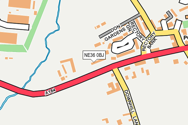
NE36 0BJ lies on Newcastle Road in West Boldon, East Boldon. NE36 0BJ is located in the Boldon Colliery electoral ward, within the metropolitan district of South Tyneside and the English Parliamentary constituency of Jarrow. The Sub Integrated Care Board (ICB) Location is NHS North East and North Cumbria ICB - 00N and the police force is Northumbria. This postcode has been in use since January 1980.


GetTheData
Source: OS OpenMap – Local (Ordnance Survey)
Source: OS VectorMap District (Ordnance Survey)
Licence: Open Government Licence (requires attribution)
| Easting | 434799 |
| Northing | 560981 |
| Latitude | 54.942284 |
| Longitude | -1.458321 |
GetTheData
Source: Open Postcode Geo
Licence: Open Government Licence
| Street | Newcastle Road |
| Locality | West Boldon |
| Town/City | East Boldon |
| Country | England |
| Postcode District | NE36 |
➜ See where NE36 is on a map ➜ Where is West Boldon? | |
GetTheData
Source: Land Registry Price Paid Data
Licence: Open Government Licence
Elevation or altitude of NE36 0BJ as distance above sea level:
| Metres | Feet | |
|---|---|---|
| Elevation | 40m | 131ft |
Elevation is measured from the approximate centre of the postcode, to the nearest point on an OS contour line from OS Terrain 50, which has contour spacing of ten vertical metres.
➜ How high above sea level am I? Find the elevation of your current position using your device's GPS.
GetTheData
Source: Open Postcode Elevation
Licence: Open Government Licence
| Ward | Boldon Colliery |
| Constituency | Jarrow |
GetTheData
Source: ONS Postcode Database
Licence: Open Government Licence
| Newcastle Road-wayside (Newcastle Road) | West Boldon | 43m |
| Addison Road | West Boldon | 108m |
| Boldon C Of E School (North Road) | West Boldon | 214m |
| North Road | West Boldon | 223m |
| North Road-school (North Road) | West Boldon | 239m |
| Brockley Whins Station | 1.9km |
| East Boldon Station | 2.5km |
| Seaburn Station | 4.8km |
GetTheData
Source: NaPTAN
Licence: Open Government Licence
| Percentage of properties with Next Generation Access | 100.0% |
| Percentage of properties with Superfast Broadband | 100.0% |
| Percentage of properties with Ultrafast Broadband | 0.0% |
| Percentage of properties with Full Fibre Broadband | 0.0% |
Superfast Broadband is between 30Mbps and 300Mbps
Ultrafast Broadband is > 300Mbps
| Percentage of properties unable to receive 2Mbps | 0.0% |
| Percentage of properties unable to receive 5Mbps | 0.0% |
| Percentage of properties unable to receive 10Mbps | 0.0% |
| Percentage of properties unable to receive 30Mbps | 0.0% |
GetTheData
Source: Ofcom
Licence: Ofcom Terms of Use (requires attribution)
GetTheData
Source: ONS Postcode Database
Licence: Open Government Licence


➜ Get more ratings from the Food Standards Agency
GetTheData
Source: Food Standards Agency
Licence: FSA terms & conditions
| Last Collection | |||
|---|---|---|---|
| Location | Mon-Fri | Sat | Distance |
| West Boldon Post Office | 16:45 | 10:30 | 313m |
| Newtown Post Office | 16:45 | 10:30 | 634m |
| Wheatley Gardens | 16:45 | 10:30 | 636m |
GetTheData
Source: Dracos
Licence: Creative Commons Attribution-ShareAlike
The below table lists the International Territorial Level (ITL) codes (formerly Nomenclature of Territorial Units for Statistics (NUTS) codes) and Local Administrative Units (LAU) codes for NE36 0BJ:
| ITL 1 Code | Name |
|---|---|
| TLC | North East (England) |
| ITL 2 Code | Name |
| TLC2 | Northumberland, and Tyne and Wear |
| ITL 3 Code | Name |
| TLC22 | Tyneside |
| LAU 1 Code | Name |
| E08000023 | South Tyneside |
GetTheData
Source: ONS Postcode Directory
Licence: Open Government Licence
The below table lists the Census Output Area (OA), Lower Layer Super Output Area (LSOA), and Middle Layer Super Output Area (MSOA) for NE36 0BJ:
| Code | Name | |
|---|---|---|
| OA | E00043738 | |
| LSOA | E01008615 | South Tyneside 023B |
| MSOA | E02001790 | South Tyneside 023 |
GetTheData
Source: ONS Postcode Directory
Licence: Open Government Licence
| NE36 0DD | Glebe Farm Court | 98m |
| NE36 0DA | 107m | |
| NE36 0AT | Ashby Villas | 112m |
| NE36 0QE | Don Gardens | 127m |
| NE36 0QD | Rectory Green | 149m |
| NE36 0QB | Rectory Terrace | 157m |
| NE36 0QF | Rectory Bank | 194m |
| NE36 0QA | Gateshead Terrace | 208m |
| NE36 0QQ | Rectory Bank | 255m |
| NE36 0AZ | Lawn Drive | 258m |
GetTheData
Source: Open Postcode Geo; Land Registry Price Paid Data
Licence: Open Government Licence