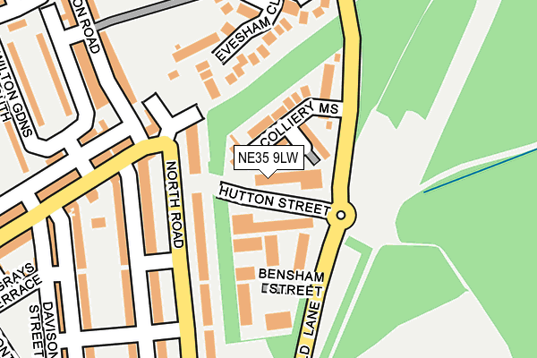
NE35 9LW is located in the Boldon Colliery electoral ward, within the metropolitan district of South Tyneside and the English Parliamentary constituency of Jarrow. The Sub Integrated Care Board (ICB) Location is NHS North East and North Cumbria ICB - 00N and the police force is Northumbria. This postcode has been in use since February 1990.


GetTheData
Source: OS OpenMap – Local (Ordnance Survey)
Source: OS VectorMap District (Ordnance Survey)
Licence: Open Government Licence (requires attribution)
| Easting | 434557 |
| Northing | 562179 |
| Latitude | 54.953074 |
| Longitude | -1.461968 |
GetTheData
Source: Open Postcode Geo
Licence: Open Government Licence
| Country | England |
| Postcode District | NE35 |
➜ See where NE35 is on a map | |
GetTheData
Source: Land Registry Price Paid Data
Licence: Open Government Licence
Elevation or altitude of NE35 9LW as distance above sea level:
| Metres | Feet | |
|---|---|---|
| Elevation | 30m | 98ft |
Elevation is measured from the approximate centre of the postcode, to the nearest point on an OS contour line from OS Terrain 50, which has contour spacing of ten vertical metres.
➜ How high above sea level am I? Find the elevation of your current position using your device's GPS.
GetTheData
Source: Open Postcode Elevation
Licence: Open Government Licence
| Ward | Boldon Colliery |
| Constituency | Jarrow |
GetTheData
Source: ONS Postcode Database
Licence: Open Government Licence
| North Road-hedworth Lane (North Road) | Boldon Colliery | 119m |
| Cotswold Lane-workshops (Cotswold Lane) | Boldon Colliery | 128m |
| Hedworth Lane-donkins Street (Hedworth Lane) | Boldon Colliery | 221m |
| North Road-hedworth House (North Road) | Boldon Colliery | 258m |
| North Road-hedworth House (North Road) | Boldon Colliery | 288m |
| Brockley Whins (Tyne And Wear Metro Station) (Station Road) | Brockley Whins | 722m |
| Brockley Whins Station | 0.7km |
| East Boldon Station | 2.8km |
| Seaburn Station | 5.5km |
GetTheData
Source: NaPTAN
Licence: Open Government Licence
Estimated total energy consumption in NE35 9LW by fuel type, 2015.
| Consumption (kWh) | 201,567 |
|---|---|
| Meter count | 15 |
| Mean (kWh/meter) | 13,438 |
| Median (kWh/meter) | 1,759 |
GetTheData
Source: Postcode level gas estimates: 2015 (experimental)
Source: Postcode level electricity estimates: 2015 (experimental)
Licence: Open Government Licence
GetTheData
Source: ONS Postcode Database
Licence: Open Government Licence


➜ Get more ratings from the Food Standards Agency
GetTheData
Source: Food Standards Agency
Licence: FSA terms & conditions
| Last Collection | |||
|---|---|---|---|
| Location | Mon-Fri | Sat | Distance |
| Boldon Colliery Post Office | 16:30 | 10:30 | 190m |
| Cotswolds Lane | 16:30 | 10:30 | 393m |
| Asda | 17:00 | 13:00 | 540m |
GetTheData
Source: Dracos
Licence: Creative Commons Attribution-ShareAlike
The below table lists the International Territorial Level (ITL) codes (formerly Nomenclature of Territorial Units for Statistics (NUTS) codes) and Local Administrative Units (LAU) codes for NE35 9LW:
| ITL 1 Code | Name |
|---|---|
| TLC | North East (England) |
| ITL 2 Code | Name |
| TLC2 | Northumberland, and Tyne and Wear |
| ITL 3 Code | Name |
| TLC22 | Tyneside |
| LAU 1 Code | Name |
| E08000023 | South Tyneside |
GetTheData
Source: ONS Postcode Directory
Licence: Open Government Licence
The below table lists the Census Output Area (OA), Lower Layer Super Output Area (LSOA), and Middle Layer Super Output Area (MSOA) for NE35 9LW:
| Code | Name | |
|---|---|---|
| OA | E00043716 | |
| LSOA | E01008613 | South Tyneside 021D |
| MSOA | E02001788 | South Tyneside 021 |
GetTheData
Source: ONS Postcode Directory
Licence: Open Government Licence
| NE35 9NJ | Colliery Mews | 114m |
| NE35 9AE | Wells Street | 117m |
| NE35 9AA | The Terrace | 132m |
| NE35 9HU | Fenwick Street | 156m |
| NE35 9HX | Toppings Street | 198m |
| NE35 9HR | 203m | |
| NE35 9HT | Hedworth Lane | 210m |
| NE35 9BB | Oxley Mews | 211m |
| NE35 9HS | Hedworth Lane | 218m |
| NE35 9HY | Donkins Street | 250m |
GetTheData
Source: Open Postcode Geo; Land Registry Price Paid Data
Licence: Open Government Licence