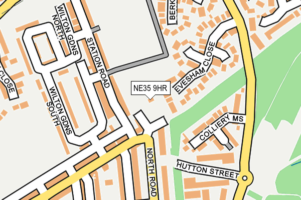
NE35 9HR is in Boldon Colliery. NE35 9HR is located in the Boldon Colliery electoral ward, within the metropolitan district of South Tyneside and the English Parliamentary constituency of Jarrow. The Sub Integrated Care Board (ICB) Location is NHS North East and North Cumbria ICB - 00N and the police force is Northumbria. This postcode has been in use since January 1980.


GetTheData
Source: OS OpenMap – Local (Ordnance Survey)
Source: OS VectorMap District (Ordnance Survey)
Licence: Open Government Licence (requires attribution)
| Easting | 434441 |
| Northing | 562346 |
| Latitude | 54.954575 |
| Longitude | -1.463746 |
GetTheData
Source: Open Postcode Geo
Licence: Open Government Licence
| Town/City | Boldon Colliery |
| Country | England |
| Postcode District | NE35 |
➜ See where NE35 is on a map | |
GetTheData
Source: Land Registry Price Paid Data
Licence: Open Government Licence
Elevation or altitude of NE35 9HR as distance above sea level:
| Metres | Feet | |
|---|---|---|
| Elevation | 30m | 98ft |
Elevation is measured from the approximate centre of the postcode, to the nearest point on an OS contour line from OS Terrain 50, which has contour spacing of ten vertical metres.
➜ How high above sea level am I? Find the elevation of your current position using your device's GPS.
GetTheData
Source: Open Postcode Elevation
Licence: Open Government Licence
| Ward | Boldon Colliery |
| Constituency | Jarrow |
GetTheData
Source: ONS Postcode Database
Licence: Open Government Licence
| North Road-hedworth Lane (North Road) | Boldon Colliery | 126m |
| Hedworth Lane-donkins Street (Hedworth Lane) | Boldon Colliery | 161m |
| Cotswold Lane-workshops (Cotswold Lane) | Boldon Colliery | 207m |
| Cotswolds Estate (Cotswold Lane) | Boldon Colliery | 286m |
| Cotswolds Estate (Cotswold Lane) | Boldon Colliery | 295m |
| Brockley Whins (Tyne And Wear Metro Station) (Station Road) | Brockley Whins | 574m |
| Fellgate (Tyne And Wear Metro Station) (Leam Lane) | Fellgate | 1,442m |
| Brockley Whins Station | 0.6km |
| East Boldon Station | 2.9km |
| Seaburn Station | 5.7km |
GetTheData
Source: NaPTAN
Licence: Open Government Licence
| Percentage of properties with Next Generation Access | 100.0% |
| Percentage of properties with Superfast Broadband | 100.0% |
| Percentage of properties with Ultrafast Broadband | 0.0% |
| Percentage of properties with Full Fibre Broadband | 0.0% |
Superfast Broadband is between 30Mbps and 300Mbps
Ultrafast Broadband is > 300Mbps
| Percentage of properties unable to receive 2Mbps | 0.0% |
| Percentage of properties unable to receive 5Mbps | 0.0% |
| Percentage of properties unable to receive 10Mbps | 0.0% |
| Percentage of properties unable to receive 30Mbps | 0.0% |
GetTheData
Source: Ofcom
Licence: Ofcom Terms of Use (requires attribution)
GetTheData
Source: ONS Postcode Database
Licence: Open Government Licence


➜ Get more ratings from the Food Standards Agency
GetTheData
Source: Food Standards Agency
Licence: FSA terms & conditions
| Last Collection | |||
|---|---|---|---|
| Location | Mon-Fri | Sat | Distance |
| Boldon Colliery Post Office | 16:30 | 10:30 | 105m |
| Cotswolds Lane | 16:30 | 10:30 | 272m |
| Hedworth Lane | 16:45 | 10:30 | 490m |
GetTheData
Source: Dracos
Licence: Creative Commons Attribution-ShareAlike
The below table lists the International Territorial Level (ITL) codes (formerly Nomenclature of Territorial Units for Statistics (NUTS) codes) and Local Administrative Units (LAU) codes for NE35 9HR:
| ITL 1 Code | Name |
|---|---|
| TLC | North East (England) |
| ITL 2 Code | Name |
| TLC2 | Northumberland, and Tyne and Wear |
| ITL 3 Code | Name |
| TLC22 | Tyneside |
| LAU 1 Code | Name |
| E08000023 | South Tyneside |
GetTheData
Source: ONS Postcode Directory
Licence: Open Government Licence
The below table lists the Census Output Area (OA), Lower Layer Super Output Area (LSOA), and Middle Layer Super Output Area (MSOA) for NE35 9HR:
| Code | Name | |
|---|---|---|
| OA | E00043719 | |
| LSOA | E01008612 | South Tyneside 021C |
| MSOA | E02001788 | South Tyneside 021 |
GetTheData
Source: ONS Postcode Directory
Licence: Open Government Licence
| NE35 9HN | Brockley Terrace | 67m |
| NE35 9AA | The Terrace | 79m |
| NE35 9HW | Coronation Terrace | 98m |
| NE35 9HT | Hedworth Lane | 123m |
| NE35 9HS | Hedworth Lane | 135m |
| NE35 9LL | Evesham Close | 137m |
| NE35 9HH | Roseberry Terrace | 154m |
| NE35 9NJ | Colliery Mews | 155m |
| NE35 9BB | Oxley Mews | 166m |
| NE35 9HG | Wilton Gardens South | 168m |
GetTheData
Source: Open Postcode Geo; Land Registry Price Paid Data
Licence: Open Government Licence