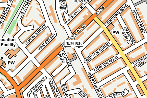
NE34 0BR is located in the Biddick and All Saints electoral ward, within the metropolitan district of South Tyneside and the English Parliamentary constituency of South Shields. The Sub Integrated Care Board (ICB) Location is NHS North East and North Cumbria ICB - 00N and the police force is Northumbria. This postcode has been in use since January 2009.


GetTheData
Source: OS OpenMap – Local (Ordnance Survey)
Source: OS VectorMap District (Ordnance Survey)
Licence: Open Government Licence (requires attribution)
| Easting | 436152 |
| Northing | 564742 |
| Latitude | 54.975984 |
| Longitude | -1.436730 |
GetTheData
Source: Open Postcode Geo
Licence: Open Government Licence
| Country | England |
| Postcode District | NE34 |
| ➜ NE34 open data dashboard ➜ See where NE34 is on a map ➜ Where is South Shields? | |
GetTheData
Source: Land Registry Price Paid Data
Licence: Open Government Licence
Elevation or altitude of NE34 0BR as distance above sea level:
| Metres | Feet | |
|---|---|---|
| Elevation | 20m | 66ft |
Elevation is measured from the approximate centre of the postcode, to the nearest point on an OS contour line from OS Terrain 50, which has contour spacing of ten vertical metres.
➜ How high above sea level am I? Find the elevation of your current position using your device's GPS.
GetTheData
Source: Open Postcode Elevation
Licence: Open Government Licence
| Ward | Biddick And All Saints |
| Constituency | South Shields |
GetTheData
Source: ONS Postcode Database
Licence: Open Government Licence
| January 2024 | Drugs | On or near Vine Street | 152m |
| January 2024 | Other theft | On or near Vine Street | 152m |
| January 2024 | Public order | On or near Vine Street | 152m |
| ➜ Get more crime data in our Crime section | |||
GetTheData
Source: data.police.uk
Licence: Open Government Licence
| Stanhope Road-gresford Street (Stanhope Road) | West Harton | 119m |
| Stanhope Rd-talbot Road (Stanhope Road) | West Harton | 122m |
| Stanhope Road-alnwick Road (Stanhope Road) | West Harton | 191m |
| Stanhope Road-boldon Lane (B1298) | West Harton | 204m |
| Stanhope Road-boldon Lane (Stanhope Road) | West Harton | 205m |
| Tyne Dock (Tyne And Wear Metro Station) (Napier Street) | Tyne Dock | 318m |
| Chichester (Tyne And Wear Metro Station) (Laygate) | Chichester | 1,202m |
| Simonside (Tyne And Wear Metro Station) (Not Specified) | Simonside | 1,256m |
| Brockley Whins Station | 2.4km |
| East Boldon Station | 3.5km |
GetTheData
Source: NaPTAN
Licence: Open Government Licence
GetTheData
Source: ONS Postcode Database
Licence: Open Government Licence


➜ Get more ratings from the Food Standards Agency
GetTheData
Source: Food Standards Agency
Licence: FSA terms & conditions
| Last Collection | |||
|---|---|---|---|
| Location | Mon-Fri | Sat | Distance |
| Stanhope Road | 16:15 | 09:30 | 221m |
| West Park Post Office | 17:30 | 10:30 | 271m |
| Harton Lane | 16:45 | 09:30 | 422m |
GetTheData
Source: Dracos
Licence: Creative Commons Attribution-ShareAlike
| Facility | Distance |
|---|---|
| Stanhope Primary School Gresford Street, South Shields Swimming Pool, Sports Hall | 260m |
| St Wilfrids Rc College Temple Park Road, South Shields Grass Pitches, Sports Hall | 486m |
| West Park (South Shields) West Park Road, South Shields Outdoor Tennis Courts | 702m |
GetTheData
Source: Active Places
Licence: Open Government Licence
| School | Phase of Education | Distance |
|---|---|---|
| SS Peter and Paul Catholic Primary School, South Shields Olive Street, South Shields, NE33 4RH | Primary | 256m |
| Stanhope Primary School Gresford Street, South Shields, NE33 4SZ | Primary | 281m |
| Alternative Education Service - The Beacon Centre Temple Park Road, South Shields, NE34 0QA | Not applicable | 366m |
GetTheData
Source: Edubase
Licence: Open Government Licence
The below table lists the International Territorial Level (ITL) codes (formerly Nomenclature of Territorial Units for Statistics (NUTS) codes) and Local Administrative Units (LAU) codes for NE34 0BR:
| ITL 1 Code | Name |
|---|---|
| TLC | North East (England) |
| ITL 2 Code | Name |
| TLC2 | Northumberland, and Tyne and Wear |
| ITL 3 Code | Name |
| TLC22 | Tyneside |
| LAU 1 Code | Name |
| E08000023 | South Tyneside |
GetTheData
Source: ONS Postcode Directory
Licence: Open Government Licence
The below table lists the Census Output Area (OA), Lower Layer Super Output Area (LSOA), and Middle Layer Super Output Area (MSOA) for NE34 0BR:
| Code | Name | |
|---|---|---|
| OA | E00043621 | |
| LSOA | E01008591 | South Tyneside 011B |
| MSOA | E02001778 | South Tyneside 011 |
GetTheData
Source: ONS Postcode Directory
Licence: Open Government Licence
| NE34 0QQ | Richmond Road | 78m |
| NE34 0JR | Farnham Road | 91m |
| NE33 4QY | Stanhope Road | 97m |
| NE33 4QZ | Stanhope Road | 98m |
| NE34 0JS | Stoddart Street | 103m |
| NE33 4TD | Stanhope Road | 104m |
| NE34 0QH | Egerton Road | 104m |
| NE34 0QP | Crofton Street | 107m |
| NE33 4TA | Stanhope Road | 111m |
| NE33 4RG | Vine Street | 120m |
GetTheData
Source: Open Postcode Geo; Land Registry Price Paid Data
Licence: Open Government Licence