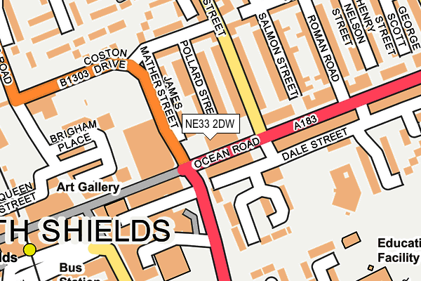
NE33 2DW is located in the Beacon and Bents electoral ward, within the metropolitan district of South Tyneside and the English Parliamentary constituency of South Shields. The Sub Integrated Care Board (ICB) Location is NHS North East and North Cumbria ICB - 00N and the police force is Northumbria. This postcode has been in use since January 1980.


GetTheData
Source: OS OpenMap – Local (Ordnance Survey)
Source: OS VectorMap District (Ordnance Survey)
Licence: Open Government Licence (requires attribution)
| Easting | 436602 |
| Northing | 567371 |
| Latitude | 54.999575 |
| Longitude | -1.429365 |
GetTheData
Source: Open Postcode Geo
Licence: Open Government Licence
| Country | England |
| Postcode District | NE33 |
| ➜ NE33 open data dashboard ➜ See where NE33 is on a map ➜ Where is South Shields? | |
GetTheData
Source: Land Registry Price Paid Data
Licence: Open Government Licence
Elevation or altitude of NE33 2DW as distance above sea level:
| Metres | Feet | |
|---|---|---|
| Elevation | 10m | 33ft |
Elevation is measured from the approximate centre of the postcode, to the nearest point on an OS contour line from OS Terrain 50, which has contour spacing of ten vertical metres.
➜ How high above sea level am I? Find the elevation of your current position using your device's GPS.
GetTheData
Source: Open Postcode Elevation
Licence: Open Government Licence
| Ward | Beacon And Bents |
| Constituency | South Shields |
GetTheData
Source: ONS Postcode Database
Licence: Open Government Licence
| January 2024 | Bicycle theft | On or near Parking Area | 137m |
| January 2024 | Burglary | On or near Parking Area | 137m |
| January 2024 | Other theft | On or near Parking Area | 137m |
| ➜ Get more crime data in our Crime section | |||
GetTheData
Source: data.police.uk
Licence: Open Government Licence
| Anderson Street-ocean Road (Anderson Street) | South Shields | 65m |
| Anderson Street-library (Anderson Street) | South Shields | 111m |
| Ocean Road | South Shields | 145m |
| Ocean Road | South Shields | 174m |
| Fowler Street-prince George Square (Fowler Street) | South Shields | 231m |
| South Shields (Tyne And Wear Metro Station) (Smithy Street) | South Shields | 271m |
| Chichester (Tyne And Wear Metro Station) (Laygate) | Chichester | 1,473m |
| North Shields (Tyne And Wear Metro Station) (Railway Terrace) | North Shields | 1,568m |
| Brockley Whins Station | 4.9km |
GetTheData
Source: NaPTAN
Licence: Open Government Licence
GetTheData
Source: ONS Postcode Database
Licence: Open Government Licence


➜ Get more ratings from the Food Standards Agency
GetTheData
Source: Food Standards Agency
Licence: FSA terms & conditions
| Last Collection | |||
|---|---|---|---|
| Location | Mon-Fri | Sat | Distance |
| Ocean Road | 17:30 | 10:00 | 117m |
| The Royal Hotel | 16:15 | 10:30 | 193m |
| South Shields Post Office | 18:30 | 12:00 | 267m |
GetTheData
Source: Dracos
Licence: Creative Commons Attribution-ShareAlike
| Facility | Distance |
|---|---|
| Ocean Road Community Centre Ocean Road, South Shields Sports Hall | 4m |
| Olympic Fitness Centre (Closed) Fowler Street, South Shields Health and Fitness Gym | 229m |
| Market Health Spa Queen Street, South Shields Health and Fitness Gym | 384m |
GetTheData
Source: Active Places
Licence: Open Government Licence
| School | Phase of Education | Distance |
|---|---|---|
| Marine Park Primary School Hatfield Square, Woodbine Estate, South Shields, NE33 2RD | Primary | 283m |
| Hadrian Primary School Baring Street, Hadrian Primary School, South Shields, NE33 2BB | Primary | 512m |
| St Bede's Catholic Primary School, South Shields Claypath Lane, South Shields, NE33 4PG | Primary | 705m |
GetTheData
Source: Edubase
Licence: Open Government Licence
The below table lists the International Territorial Level (ITL) codes (formerly Nomenclature of Territorial Units for Statistics (NUTS) codes) and Local Administrative Units (LAU) codes for NE33 2DW:
| ITL 1 Code | Name |
|---|---|
| TLC | North East (England) |
| ITL 2 Code | Name |
| TLC2 | Northumberland, and Tyne and Wear |
| ITL 3 Code | Name |
| TLC22 | Tyneside |
| LAU 1 Code | Name |
| E08000023 | South Tyneside |
GetTheData
Source: ONS Postcode Directory
Licence: Open Government Licence
The below table lists the Census Output Area (OA), Lower Layer Super Output Area (LSOA), and Middle Layer Super Output Area (MSOA) for NE33 2DW:
| Code | Name | |
|---|---|---|
| OA | E00043649 | |
| LSOA | E01008596 | South Tyneside 001B |
| MSOA | E02001768 | South Tyneside 001 |
GetTheData
Source: ONS Postcode Directory
Licence: Open Government Licence
| NE33 2JD | Ocean Road | 37m |
| NE33 2DP | Pollard Street | 77m |
| NE33 2DN | James Mather Street | 80m |
| NE33 2PB | Anderson Street | 113m |
| NE33 2DR | Baring Street | 113m |
| NE33 2PA | Chatsworth Court | 119m |
| NE33 2DX | Coston Drive | 146m |
| NE33 2JJ | Ocean Road | 147m |
| NE33 2JF | Ocean Road | 156m |
| NE33 2RH | Blenheim Walk | 165m |
GetTheData
Source: Open Postcode Geo; Land Registry Price Paid Data
Licence: Open Government Licence