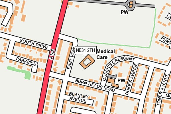
NE31 2TH is located in the Hebburn South electoral ward, within the metropolitan district of South Tyneside and the English Parliamentary constituency of Jarrow. The Sub Integrated Care Board (ICB) Location is NHS North East and North Cumbria ICB - 00N and the police force is Northumbria. This postcode has been in use since January 1980.


GetTheData
Source: OS OpenMap – Local (Ordnance Survey)
Source: OS VectorMap District (Ordnance Survey)
Licence: Open Government Licence (requires attribution)
| Easting | 430716 |
| Northing | 563662 |
| Latitude | 54.966650 |
| Longitude | -1.521781 |
GetTheData
Source: Open Postcode Geo
Licence: Open Government Licence
| Country | England |
| Postcode District | NE31 |
| ➜ NE31 open data dashboard ➜ See where NE31 is on a map ➜ Where is Hebburn? | |
GetTheData
Source: Land Registry Price Paid Data
Licence: Open Government Licence
Elevation or altitude of NE31 2TH as distance above sea level:
| Metres | Feet | |
|---|---|---|
| Elevation | 40m | 131ft |
Elevation is measured from the approximate centre of the postcode, to the nearest point on an OS contour line from OS Terrain 50, which has contour spacing of ten vertical metres.
➜ How high above sea level am I? Find the elevation of your current position using your device's GPS.
GetTheData
Source: Open Postcode Elevation
Licence: Open Government Licence
| Ward | Hebburn South |
| Constituency | Jarrow |
GetTheData
Source: ONS Postcode Database
Licence: Open Government Licence
| January 2024 | Shoplifting | On or near Petrol Station | 341m |
| January 2024 | Other theft | On or near Petrol Station | 341m |
| January 2024 | Vehicle crime | On or near Kelly Road | 418m |
| ➜ Get more crime data in our Crime section | |||
GetTheData
Source: data.police.uk
Licence: Open Government Licence
| Burn Heads Road-queens Crescent (Burn Heads Road) | Hebburn | 118m |
| Victoria Road West-south Drive (Virctoria Road West) | Hebburn | 128m |
| Victoria Road West-burnheads Road (Victoria Road West) | Hebburn | 131m |
| Victoria Road West-sports Ground (Victoria Road) | Hebburn | 173m |
| Crawley Avenue-burn Heads Road (Crawley Avenue) | Hebburn | 175m |
| Hebburn (Tyne And Wear Metro Station) (Prince Consort Road) | Hebburn | 1,004m |
| Heworth Station | 2.7km |
| Brockley Whins Station | 3.9km |
GetTheData
Source: NaPTAN
Licence: Open Government Licence
GetTheData
Source: ONS Postcode Database
Licence: Open Government Licence


➜ Get more ratings from the Food Standards Agency
GetTheData
Source: Food Standards Agency
Licence: FSA terms & conditions
| Last Collection | |||
|---|---|---|---|
| Location | Mon-Fri | Sat | Distance |
| Victoria Road West Post Office | 17:30 | 10:30 | 330m |
| Tharsis Road | 17:30 | 10:30 | 345m |
| Mountbatten Avenue | 16:00 | 10:00 | 393m |
GetTheData
Source: Dracos
Licence: Creative Commons Attribution-ShareAlike
| Facility | Distance |
|---|---|
| Hebburn Sports Club South Drive, Hebburn Health and Fitness Gym, Grass Pitches | 243m |
| Carr Ellison Park Canning Street, Hebburn Outdoor Tennis Courts, Grass Pitches | 564m |
| Hebburn Riverside Park (Findus) South Drive, Hebburn Grass Pitches | 564m |
GetTheData
Source: Active Places
Licence: Open Government Licence
| School | Phase of Education | Distance |
|---|---|---|
| Toner Avenue Primary School Johnston Avenue, Hebburn, NE31 2LJ | Primary | 440m |
| Hebburn Comprehensive School Campbell Park Road, Hebburn, NE31 2QU | Secondary | 604m |
| St Joseph's Catholic Academy Mill Lane, Hebburn, NE31 2ET | Secondary | 754m |
GetTheData
Source: Edubase
Licence: Open Government Licence
The below table lists the International Territorial Level (ITL) codes (formerly Nomenclature of Territorial Units for Statistics (NUTS) codes) and Local Administrative Units (LAU) codes for NE31 2TH:
| ITL 1 Code | Name |
|---|---|
| TLC | North East (England) |
| ITL 2 Code | Name |
| TLC2 | Northumberland, and Tyne and Wear |
| ITL 3 Code | Name |
| TLC22 | Tyneside |
| LAU 1 Code | Name |
| E08000023 | South Tyneside |
GetTheData
Source: ONS Postcode Directory
Licence: Open Government Licence
The below table lists the Census Output Area (OA), Lower Layer Super Output Area (LSOA), and Middle Layer Super Output Area (MSOA) for NE31 2TH:
| Code | Name | |
|---|---|---|
| OA | E00043893 | |
| LSOA | E01008646 | South Tyneside 015D |
| MSOA | E02001782 | South Tyneside 015 |
GetTheData
Source: ONS Postcode Directory
Licence: Open Government Licence
| NE31 2TQ | East View | 61m |
| NE31 1UL | Victoria Road West | 100m |
| NE31 2TB | Burn Heads Road | 107m |
| NE31 2TA | Burn Heads Road | 123m |
| NE31 2TF | Queens Crescent | 128m |
| NE31 2TG | Dukes Avenue | 163m |
| NE31 2NH | Beanley Avenue | 165m |
| NE31 2TD | Burn Heads Road | 197m |
| NE31 1UN | South Drive | 199m |
| NE31 2NQ | Prendwick Court | 204m |
GetTheData
Source: Open Postcode Geo; Land Registry Price Paid Data
Licence: Open Government Licence