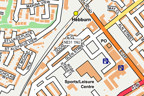
NE31 1NU is in Shield Street, Hebburn. NE31 1NU is located in the Hebburn North electoral ward, within the metropolitan district of South Tyneside and the English Parliamentary constituency of Jarrow. The Sub Integrated Care Board (ICB) Location is NHS North East and North Cumbria ICB - 00N and the police force is Northumbria. This postcode has been in use since January 1980.


GetTheData
Source: OS OpenMap – Local (Ordnance Survey)
Source: OS VectorMap District (Ordnance Survey)
Licence: Open Government Licence (requires attribution)
| Easting | 430704 |
| Northing | 564464 |
| Latitude | 54.973850 |
| Longitude | -1.521870 |
GetTheData
Source: Open Postcode Geo
Licence: Open Government Licence
| Locality | Shield Street |
| Town/City | Hebburn |
| Country | England |
| Postcode District | NE31 |
| ➜ NE31 open data dashboard ➜ See where NE31 is on a map ➜ Where is Hebburn? | |
GetTheData
Source: Land Registry Price Paid Data
Licence: Open Government Licence
Elevation or altitude of NE31 1NU as distance above sea level:
| Metres | Feet | |
|---|---|---|
| Elevation | 30m | 98ft |
Elevation is measured from the approximate centre of the postcode, to the nearest point on an OS contour line from OS Terrain 50, which has contour spacing of ten vertical metres.
➜ How high above sea level am I? Find the elevation of your current position using your device's GPS.
GetTheData
Source: Open Postcode Elevation
Licence: Open Government Licence
| Ward | Hebburn North |
| Constituency | Jarrow |
GetTheData
Source: ONS Postcode Database
Licence: Open Government Licence
| January 2024 | Criminal damage and arson | On or near Tweed Street | 321m |
| January 2024 | Criminal damage and arson | On or near Hall Road | 384m |
| January 2024 | Anti-social behaviour | On or near Hall Road | 384m |
| ➜ Get more crime data in our Crime section | |||
GetTheData
Source: data.police.uk
Licence: Open Government Licence
| Hebburn (Station Road) | Hebburn | 148m |
| Hebburn (Station Road) | Hebburn | 161m |
| Station Road | Hebburn | 187m |
| Station Road - Fountain Park (Station Road) | Hebburn | 201m |
| Victoria Road West - Hall Road (Victoria Road West) | Hebburn | 302m |
| Hebburn (Tyne And Wear Metro Station) (Prince Consort Road) | Hebburn | 218m |
| Heworth Station | 3.3km |
| Brockley Whins Station | 4.2km |
GetTheData
Source: NaPTAN
Licence: Open Government Licence
GetTheData
Source: ONS Postcode Database
Licence: Open Government Licence


➜ Get more ratings from the Food Standards Agency
GetTheData
Source: Food Standards Agency
Licence: FSA terms & conditions
| Last Collection | |||
|---|---|---|---|
| Location | Mon-Fri | Sat | Distance |
| Hebburn Post Office | 18:00 | 11:30 | 165m |
| Tharsis Road | 17:30 | 10:30 | 457m |
| Jutland Avenue | 16:30 | 10:30 | 475m |
GetTheData
Source: Dracos
Licence: Creative Commons Attribution-ShareAlike
| Facility | Distance |
|---|---|
| Hebburn Central Glen Street, Hebburn Swimming Pool, Health and Fitness Gym, Sports Hall, Studio | 124m |
| Viking Gym Prince Consort Road, Hebburn Health and Fitness Gym, Studio | 289m |
| Carr Ellison Park Canning Street, Hebburn Outdoor Tennis Courts, Grass Pitches | 474m |
GetTheData
Source: Active Places
Licence: Open Government Licence
| School | Phase of Education | Distance |
|---|---|---|
| St Aloysius Catholic Infant School, Hebburn Argyle Street, Hebburn, NE31 1RZ | Primary | 713m |
| St Aloysius Catholic Junior School Academy Argyle Street, Hebburn, NE31 1BQ | Primary | 732m |
| The Sue Hedley Nursery School Campbell Park Road, Hebburn, NE31 1QY | Nursery | 780m |
GetTheData
Source: Edubase
Licence: Open Government Licence
The below table lists the International Territorial Level (ITL) codes (formerly Nomenclature of Territorial Units for Statistics (NUTS) codes) and Local Administrative Units (LAU) codes for NE31 1NU:
| ITL 1 Code | Name |
|---|---|
| TLC | North East (England) |
| ITL 2 Code | Name |
| TLC2 | Northumberland, and Tyne and Wear |
| ITL 3 Code | Name |
| TLC22 | Tyneside |
| LAU 1 Code | Name |
| E08000023 | South Tyneside |
GetTheData
Source: ONS Postcode Directory
Licence: Open Government Licence
The below table lists the Census Output Area (OA), Lower Layer Super Output Area (LSOA), and Middle Layer Super Output Area (MSOA) for NE31 1NU:
| Code | Name | |
|---|---|---|
| OA | E00043860 | |
| LSOA | E01008641 | South Tyneside 010C |
| MSOA | E02001777 | South Tyneside 010 |
GetTheData
Source: ONS Postcode Directory
Licence: Open Government Licence
| NE31 1NG | Glen Street | 67m |
| NE31 1NE | Glen Street | 172m |
| NE31 1ND | St Rollox Street | 184m |
| NE31 1RL | St Michaels Vale | 193m |
| NE31 1RX | Marina View | 200m |
| NE31 1LQ | St Johns Precinct | 217m |
| NE31 1XS | Aln Street | 243m |
| NE31 1NB | Buchanan Street | 248m |
| NE31 1PW | Hedgeley Road | 249m |
| NE31 1LN | Tennant Street | 253m |
GetTheData
Source: Open Postcode Geo; Land Registry Price Paid Data
Licence: Open Government Licence