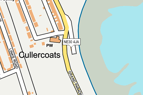
NE30 4JA is located in the Tynemouth electoral ward, within the metropolitan district of North Tyneside and the English Parliamentary constituency of Tynemouth. The Sub Integrated Care Board (ICB) Location is NHS North East and North Cumbria ICB - 99C and the police force is Northumbria. This postcode has been in use since March 2016.


GetTheData
Source: OS OpenMap – Local (Ordnance Survey)
Source: OS VectorMap District (Ordnance Survey)
Licence: Open Government Licence (requires attribution)
| Easting | 436512 |
| Northing | 570800 |
| Latitude | 55.030401 |
| Longitude | -1.430349 |
GetTheData
Source: Open Postcode Geo
Licence: Open Government Licence
| Country | England |
| Postcode District | NE30 |
| ➜ NE30 open data dashboard ➜ See where NE30 is on a map ➜ Where is Tynemouth? | |
GetTheData
Source: Land Registry Price Paid Data
Licence: Open Government Licence
Elevation or altitude of NE30 4JA as distance above sea level:
| Metres | Feet | |
|---|---|---|
| Elevation | 10m | 33ft |
Elevation is measured from the approximate centre of the postcode, to the nearest point on an OS contour line from OS Terrain 50, which has contour spacing of ten vertical metres.
➜ How high above sea level am I? Find the elevation of your current position using your device's GPS.
GetTheData
Source: Open Postcode Elevation
Licence: Open Government Licence
| Ward | Tynemouth |
| Constituency | Tynemouth |
GetTheData
Source: ONS Postcode Database
Licence: Open Government Licence
| January 2024 | Anti-social behaviour | On or near Parking Area | 202m |
| January 2024 | Burglary | On or near Parking Area | 331m |
| January 2024 | Burglary | On or near Whittingham Close | 394m |
| ➜ Get more crime data in our Crime section | |||
GetTheData
Source: data.police.uk
Licence: Open Government Licence
| Grand Parade-st Georges Church (Grand Parade) | Cullercoats | 57m |
| Beverley Terrace-beverley Gardens (Beverley Terrace) | Cullercoats | 57m |
| Grand Parade - Beach Road (Grand Parade) | Tynemouth | 327m |
| Grand Parade-sea Life Centre (Grand Parade) | Tynemouth | 332m |
| Beverley Terrace-marden Avenue (Beverley Terrace) | Cullercoats | 427m |
| Cullercoats (Tyne And Wear Metro Station) (Station Road) | Cullercoats | 641m |
| Whitley Bay (Tyne And Wear Metro Station) (Station Road) | Whitley Bay | 1,332m |
| Tynemouth (Tyne And Wear Metro Station) (Station Terrace) | Tynemouth | 1,480m |
GetTheData
Source: NaPTAN
Licence: Open Government Licence
GetTheData
Source: ONS Postcode Database
Licence: Open Government Licence


➜ Get more ratings from the Food Standards Agency
GetTheData
Source: Food Standards Agency
Licence: FSA terms & conditions
| Last Collection | |||
|---|---|---|---|
| Location | Mon-Fri | Sat | Distance |
| Beverley Terrace | 16:15 | 12:15 | 290m |
| Seacroft Avenue | 16:15 | 12:15 | 500m |
| Broadway | 16:15 | 12:15 | 528m |
GetTheData
Source: Dracos
Licence: Creative Commons Attribution-ShareAlike
| Facility | Distance |
|---|---|
| Cullercoats Lawn Tennis Club Beverley Gardens, Cullercoats Outdoor Tennis Courts | 130m |
| Links Avenue Playing Field Links Avenue, Cullercoats Grass Pitches | 366m |
| Marden High School Hartington Road, North Shields Grass Pitches, Sports Hall, Studio | 796m |
GetTheData
Source: Active Places
Licence: Open Government Licence
| School | Phase of Education | Distance |
|---|---|---|
| Cullercoats Primary School Marden Avenue, Cullercoats, North Shields, NE30 4PB | Primary | 391m |
| Marden High School Hartington Road, Cullercoats, North Shields, NE30 3RZ | Secondary | 789m |
| Monkhouse Primary School Wallington Avenue, North Shields, NE30 3SH | Primary | 974m |
GetTheData
Source: Edubase
Licence: Open Government Licence
The below table lists the International Territorial Level (ITL) codes (formerly Nomenclature of Territorial Units for Statistics (NUTS) codes) and Local Administrative Units (LAU) codes for NE30 4JA:
| ITL 1 Code | Name |
|---|---|
| TLC | North East (England) |
| ITL 2 Code | Name |
| TLC2 | Northumberland, and Tyne and Wear |
| ITL 3 Code | Name |
| TLC22 | Tyneside |
| LAU 1 Code | Name |
| E08000022 | North Tyneside |
GetTheData
Source: ONS Postcode Directory
Licence: Open Government Licence
The below table lists the Census Output Area (OA), Lower Layer Super Output Area (LSOA), and Middle Layer Super Output Area (MSOA) for NE30 4JA:
| Code | Name | |
|---|---|---|
| OA | E00043450 | |
| LSOA | E01008560 | North Tyneside 016B |
| MSOA | E02001753 | North Tyneside 016 |
GetTheData
Source: ONS Postcode Directory
Licence: Open Government Licence
| NE30 4NT | Beverley Terrace | 189m |
| NE30 4NS | Beverley Gardens | 249m |
| NE30 3EA | Links Road | 263m |
| NE30 3DZ | Links Road | 282m |
| NE30 4NU | Beverley Terrace | 282m |
| NE30 3TG | Links Road | 303m |
| NE30 3DJ | Wansbeck Avenue | 319m |
| NE30 3TH | Whittingham Close | 361m |
| NE30 3DH | Links Avenue | 368m |
| NE30 3DT | Sunlea Avenue | 388m |
GetTheData
Source: Open Postcode Geo; Land Registry Price Paid Data
Licence: Open Government Licence