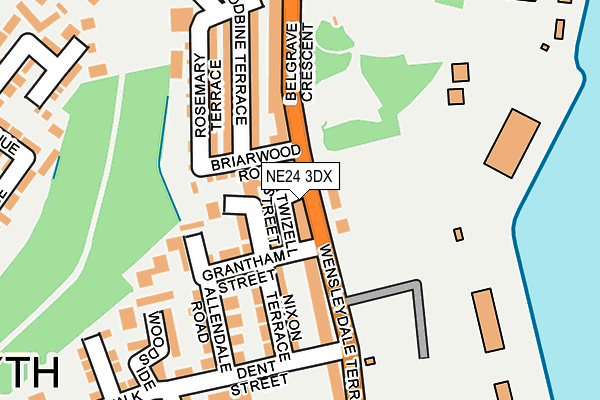
NE24 3DX is located in the Wensleydale electoral ward, within the unitary authority of Northumberland and the English Parliamentary constituency of Blyth Valley. The Sub Integrated Care Board (ICB) Location is NHS North East and North Cumbria ICB - 00L and the police force is Northumbria. This postcode has been in use since January 1980.


GetTheData
Source: OS OpenMap – Local (Ordnance Survey)
Source: OS VectorMap District (Ordnance Survey)
Licence: Open Government Licence (requires attribution)
| Easting | 431869 |
| Northing | 580806 |
| Latitude | 55.120622 |
| Longitude | -1.501853 |
GetTheData
Source: Open Postcode Geo
Licence: Open Government Licence
| Country | England |
| Postcode District | NE24 |
| ➜ NE24 open data dashboard ➜ See where NE24 is on a map ➜ Where is Blyth? | |
GetTheData
Source: Land Registry Price Paid Data
Licence: Open Government Licence
Elevation or altitude of NE24 3DX as distance above sea level:
| Metres | Feet | |
|---|---|---|
| Elevation | 0m | 0ft |
Elevation is measured from the approximate centre of the postcode, to the nearest point on an OS contour line from OS Terrain 50, which has contour spacing of ten vertical metres.
➜ How high above sea level am I? Find the elevation of your current position using your device's GPS.
GetTheData
Source: Open Postcode Elevation
Licence: Open Government Licence
| Ward | Wensleydale |
| Constituency | Blyth Valley |
GetTheData
Source: ONS Postcode Database
Licence: Open Government Licence
| January 2024 | Drugs | On or near Parking Area | 428m |
| January 2024 | Violence and sexual offences | On or near Parking Area | 428m |
| January 2024 | Drugs | On or near Parking Area | 428m |
| ➜ Get more crime data in our Crime section | |||
GetTheData
Source: data.police.uk
Licence: Open Government Licence
| Wensleydale Terrace | Blyth | 17m |
| Wensleydale Terrace | Blyth | 70m |
| Gordon Road (Wensleydale Terrace) | Blyth | 216m |
| Belgrave Crescent | Blyth | 257m |
| Belgrave Crescent | Blyth | 267m |
GetTheData
Source: NaPTAN
Licence: Open Government Licence
GetTheData
Source: ONS Postcode Database
Licence: Open Government Licence


➜ Get more ratings from the Food Standards Agency
GetTheData
Source: Food Standards Agency
Licence: FSA terms & conditions
| Last Collection | |||
|---|---|---|---|
| Location | Mon-Fri | Sat | Distance |
| Park Road | 16:00 | 10:45 | 254m |
| Gordon Road | 16:00 | 10:45 | 299m |
| Crofton Post Office | 17:30 | 12:15 | 462m |
GetTheData
Source: Dracos
Licence: Creative Commons Attribution-ShareAlike
| Facility | Distance |
|---|---|
| Wensleydale Park Playing Fields Dune Walk, Blyth Grass Pitches, Artificial Grass Pitch | 335m |
| Wensleydale Middle School (Closed) Dent Street, Blyth Sports Hall, Grass Pitches | 352m |
| Ridley Park Park View, Blyth Outdoor Tennis Courts | 394m |
GetTheData
Source: Active Places
Licence: Open Government Licence
| School | Phase of Education | Distance |
|---|---|---|
| Croftway Academy William Street, Blyth, NE24 2HP | Primary | 558m |
| St Wilfrid's Catholic Primary School Claremont Terrace, Blyth, NE24 2LE | Primary | 1.1km |
| Bede Academy Sixth Avenue, Blyth, NE24 2SY | All-through | 1.3km |
GetTheData
Source: Edubase
Licence: Open Government Licence
The below table lists the International Territorial Level (ITL) codes (formerly Nomenclature of Territorial Units for Statistics (NUTS) codes) and Local Administrative Units (LAU) codes for NE24 3DX:
| ITL 1 Code | Name |
|---|---|
| TLC | North East (England) |
| ITL 2 Code | Name |
| TLC2 | Northumberland, and Tyne and Wear |
| ITL 3 Code | Name |
| TLC21 | Northumberland |
| LAU 1 Code | Name |
| E06000057 | Northumberland |
GetTheData
Source: ONS Postcode Directory
Licence: Open Government Licence
The below table lists the Census Output Area (OA), Lower Layer Super Output Area (LSOA), and Middle Layer Super Output Area (MSOA) for NE24 3DX:
| Code | Name | |
|---|---|---|
| OA | E00139666 | |
| LSOA | E01027442 | Northumberland 023E |
| MSOA | E02005710 | Northumberland 023 |
GetTheData
Source: ONS Postcode Directory
Licence: Open Government Licence
| NE24 3DY | Wensleydale Terrace | 35m |
| NE24 3EE | Nixon Terrace | 37m |
| NE24 3EA | Grantham Street | 74m |
| NE24 3DR | Briarwood Road | 80m |
| NE24 3EB | Wensleydale Terrace | 111m |
| NE24 3EF | Nixon Terrace | 124m |
| NE24 3DW | Woodbine Terrace | 125m |
| NE24 3EG | Allendale Road | 138m |
| NE24 3DU | Belgrave Crescent | 139m |
| NE24 3DS | Rosemary Terrace | 141m |
GetTheData
Source: Open Postcode Geo; Land Registry Price Paid Data
Licence: Open Government Licence