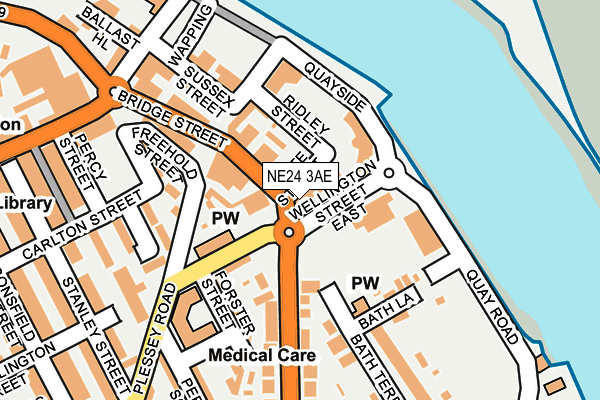
NE24 3AE is located in the Wensleydale electoral ward, within the unitary authority of Northumberland and the English Parliamentary constituency of Blyth Valley. The Sub Integrated Care Board (ICB) Location is NHS North East and North Cumbria ICB - 00L and the police force is Northumbria. This postcode has been in use since January 1980.


GetTheData
Source: OS OpenMap – Local (Ordnance Survey)
Source: OS VectorMap District (Ordnance Survey)
Licence: Open Government Licence (requires attribution)
| Easting | 431832 |
| Northing | 581552 |
| Latitude | 55.127334 |
| Longitude | -1.502363 |
GetTheData
Source: Open Postcode Geo
Licence: Open Government Licence
| Country | England |
| Postcode District | NE24 |
| ➜ NE24 open data dashboard ➜ See where NE24 is on a map ➜ Where is Blyth? | |
GetTheData
Source: Land Registry Price Paid Data
Licence: Open Government Licence
Elevation or altitude of NE24 3AE as distance above sea level:
| Metres | Feet | |
|---|---|---|
| Elevation | 10m | 33ft |
Elevation is measured from the approximate centre of the postcode, to the nearest point on an OS contour line from OS Terrain 50, which has contour spacing of ten vertical metres.
➜ How high above sea level am I? Find the elevation of your current position using your device's GPS.
GetTheData
Source: Open Postcode Elevation
Licence: Open Government Licence
| Ward | Wensleydale |
| Constituency | Blyth Valley |
GetTheData
Source: ONS Postcode Database
Licence: Open Government Licence
| January 2024 | Violence and sexual offences | On or near Shopping Area | 391m |
| January 2024 | Violence and sexual offences | On or near Havelock Street | 406m |
| January 2024 | Shoplifting | On or near Havelock Street | 406m |
| ➜ Get more crime data in our Crime section | |||
GetTheData
Source: data.police.uk
Licence: Open Government Licence
| Wellington Street (Bridge Street) | Blyth | 17m |
| Wellington Street (Ridley Avenue) | Blyth | 103m |
| Bus Station (Post Office Street) | Blyth | 307m |
| Bus Station (Bridge Street) | Blyth | 307m |
| Bus Station (Old Post Office) | Blyth | 315m |
GetTheData
Source: NaPTAN
Licence: Open Government Licence
GetTheData
Source: ONS Postcode Database
Licence: Open Government Licence


➜ Get more ratings from the Food Standards Agency
GetTheData
Source: Food Standards Agency
Licence: FSA terms & conditions
| Last Collection | |||
|---|---|---|---|
| Location | Mon-Fri | Sat | Distance |
| Wellington Street | 16:00 | 10:45 | 87m |
| Beaconfield Street | 16:45 | 10:45 | 349m |
| Croft Road | 16:45 | 11:00 | 436m |
GetTheData
Source: Dracos
Licence: Creative Commons Attribution-ShareAlike
| Facility | Distance |
|---|---|
| Body-tec Health Studio Union Street, Blyth Health and Fitness Gym | 424m |
| Ridley Park Park View, Blyth Outdoor Tennis Courts | 435m |
| Fit 2 Be Croft Road, Blyth Health and Fitness Gym, Studio | 454m |
GetTheData
Source: Active Places
Licence: Open Government Licence
| School | Phase of Education | Distance |
|---|---|---|
| Croftway Academy William Street, Blyth, NE24 2HP | Primary | 758m |
| St Wilfrid's Catholic Primary School Claremont Terrace, Blyth, NE24 2LE | Primary | 1.1km |
| Malvin's Close Academy Malvin's Close Academy, Albion Way, Malvin's Close Academy, Blyth, NE24 5BL | Primary | 1.4km |
GetTheData
Source: Edubase
Licence: Open Government Licence
The below table lists the International Territorial Level (ITL) codes (formerly Nomenclature of Territorial Units for Statistics (NUTS) codes) and Local Administrative Units (LAU) codes for NE24 3AE:
| ITL 1 Code | Name |
|---|---|
| TLC | North East (England) |
| ITL 2 Code | Name |
| TLC2 | Northumberland, and Tyne and Wear |
| ITL 3 Code | Name |
| TLC21 | Northumberland |
| LAU 1 Code | Name |
| E06000057 | Northumberland |
GetTheData
Source: ONS Postcode Directory
Licence: Open Government Licence
The below table lists the Census Output Area (OA), Lower Layer Super Output Area (LSOA), and Middle Layer Super Output Area (MSOA) for NE24 3AE:
| Code | Name | |
|---|---|---|
| OA | E00139670 | |
| LSOA | E01027442 | Northumberland 023E |
| MSOA | E02005710 | Northumberland 023 |
GetTheData
Source: ONS Postcode Directory
Licence: Open Government Licence
| NE24 3AB | Plessey Road | 70m |
| NE24 2HZ | St Cuthberts Court | 92m |
| NE24 2AP | Bridge Street | 109m |
| NE24 2AY | Sussex Street | 109m |
| NE24 3BE | Wellington Street | 110m |
| NE24 2BA | Freehold Street | 118m |
| NE24 2HY | St Cuthberts Court | 124m |
| NE24 2HX | St Cuthberts Court | 153m |
| NE24 3BG | Forster Street | 160m |
| NE24 3AT | Bath Lane | 182m |
GetTheData
Source: Open Postcode Geo; Land Registry Price Paid Data
Licence: Open Government Licence