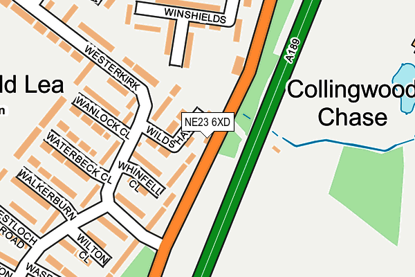
NE23 6XD lies on Sandersons Terrace in Cramlington. NE23 6XD is located in the Cramlington South East electoral ward, within the unitary authority of Northumberland and the English Parliamentary constituency of Blyth Valley. The Sub Integrated Care Board (ICB) Location is NHS North East and North Cumbria ICB - 00L and the police force is Northumbria. This postcode has been in use since January 1980.


GetTheData
Source: OS OpenMap – Local (Ordnance Survey)
Source: OS VectorMap District (Ordnance Survey)
Licence: Open Government Licence (requires attribution)
| Easting | 427224 |
| Northing | 575330 |
| Latitude | 55.071692 |
| Longitude | -1.575203 |
GetTheData
Source: Open Postcode Geo
Licence: Open Government Licence
| Street | Sandersons Terrace |
| Town/City | Cramlington |
| Country | England |
| Postcode District | NE23 |
| ➜ NE23 open data dashboard ➜ See where NE23 is on a map ➜ Where is Cramlington? | |
GetTheData
Source: Land Registry Price Paid Data
Licence: Open Government Licence
Elevation or altitude of NE23 6XD as distance above sea level:
| Metres | Feet | |
|---|---|---|
| Elevation | 50m | 164ft |
Elevation is measured from the approximate centre of the postcode, to the nearest point on an OS contour line from OS Terrain 50, which has contour spacing of ten vertical metres.
➜ How high above sea level am I? Find the elevation of your current position using your device's GPS.
GetTheData
Source: Open Postcode Elevation
Licence: Open Government Licence
| Ward | Cramlington South East |
| Constituency | Blyth Valley |
GetTheData
Source: ONS Postcode Database
Licence: Open Government Licence
1, SANDERSONS TERRACE, CRAMLINGTON, NE23 6XD 2004 8 SEP £283,500 |
1, SANDERSONS TERRACE, CRAMLINGTON, NE23 6XD 2001 5 FEB £84,500 |
1, SANDERSONS TERRACE, CRAMLINGTON, NE23 6XD 1996 18 JUL £48,500 |
GetTheData
Source: HM Land Registry Price Paid Data
Licence: Contains HM Land Registry data © Crown copyright and database right 2024. This data is licensed under the Open Government Licence v3.0.
| June 2022 | Other theft | On or near Weetwood Road | 298m |
| June 2022 | Anti-social behaviour | On or near Weetwood Road | 298m |
| June 2022 | Anti-social behaviour | On or near Weetwood Road | 298m |
| ➜ Get more crime data in our Crime section | |||
GetTheData
Source: data.police.uk
Licence: Open Government Licence
| Bay Horse (B1505) | Southfield | 31m |
| Bay Horse (B1505) | Southfield | 53m |
| Collingwood Chase (B1505) | Southfield | 304m |
| Collingwood Chase (B1505) | Southfield | 343m |
| Annitsford Church (B1505) | Southfield | 358m |
| Cramlington Station | 2.3km |
GetTheData
Source: NaPTAN
Licence: Open Government Licence
GetTheData
Source: ONS Postcode Database
Licence: Open Government Licence


➜ Get more ratings from the Food Standards Agency
GetTheData
Source: Food Standards Agency
Licence: FSA terms & conditions
| Last Collection | |||
|---|---|---|---|
| Location | Mon-Fri | Sat | Distance |
| Weetwood Road | 16:00 | 12:00 | 258m |
| Winburgh Avenue | 16:00 | 12:00 | 316m |
| Southfield Green Post Office | 17:45 | 11:45 | 467m |
GetTheData
Source: Dracos
Licence: Creative Commons Attribution-ShareAlike
| Facility | Distance |
|---|---|
| Cragside C Of E Controlled Primary School Westloch Road, Southfield Lea, Cramlington Grass Pitches | 379m |
| Ann Welfare Playing Fields High Pit Road, Cramlington Grass Pitches | 560m |
| Alexandra Park (Cramlington) Ganton Avenue, Cramlington Grass Pitches, Outdoor Tennis Courts | 710m |
GetTheData
Source: Active Places
Licence: Open Government Licence
| School | Phase of Education | Distance |
|---|---|---|
| Cragside CofE Controlled Primary School Westloch Road, Cramlington, NE23 6LW | Primary | 394m |
| Ss Peter and Paul's Catholic Primary Academy Northumbrian Road, Bishop Bewick Cet, Northumbrian Road, Cramlington, NE23 6DB | Primary | 801m |
| Cramlington Learning Village Highburn, Cramlington, NE23 6BN | Secondary | 1.2km |
GetTheData
Source: Edubase
Licence: Open Government Licence
The below table lists the International Territorial Level (ITL) codes (formerly Nomenclature of Territorial Units for Statistics (NUTS) codes) and Local Administrative Units (LAU) codes for NE23 6XD:
| ITL 1 Code | Name |
|---|---|
| TLC | North East (England) |
| ITL 2 Code | Name |
| TLC2 | Northumberland, and Tyne and Wear |
| ITL 3 Code | Name |
| TLC21 | Northumberland |
| LAU 1 Code | Name |
| E06000057 | Northumberland |
GetTheData
Source: ONS Postcode Directory
Licence: Open Government Licence
The below table lists the Census Output Area (OA), Lower Layer Super Output Area (LSOA), and Middle Layer Super Output Area (MSOA) for NE23 6XD:
| Code | Name | |
|---|---|---|
| OA | E00139477 | |
| LSOA | E01027407 | Northumberland 031C |
| MSOA | E02005718 | Northumberland 031 |
GetTheData
Source: ONS Postcode Directory
Licence: Open Government Licence
| NE23 6LH | Wildshaw Close | 58m |
| NE23 6LX | Whinfell Close | 91m |
| NE23 6LL | Wreay Walk | 97m |
| NE23 6ND | Westerkirk | 110m |
| NE23 6NA | Westerkirk | 147m |
| NE23 6LS | Wanlock Close | 161m |
| NE23 6JB | Winshields | 164m |
| NE23 6NB | Westerkirk | 174m |
| NE23 6JD | Winshields | 185m |
| NE23 6LT | Waterbeck Close | 191m |
GetTheData
Source: Open Postcode Geo; Land Registry Price Paid Data
Licence: Open Government Licence