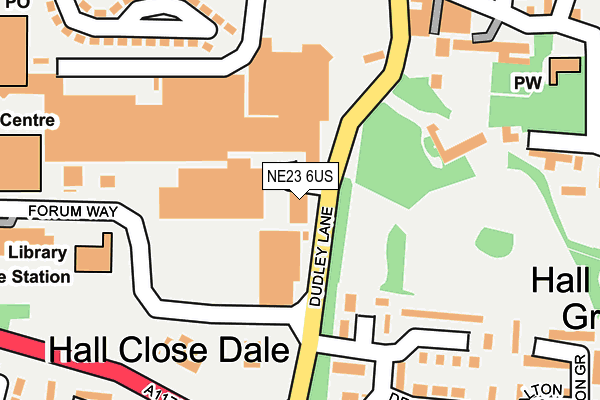
NE23 6US lies on Dudley Lane in Cramlington. NE23 6US is located in the Cramlington Village electoral ward, within the unitary authority of Northumberland and the English Parliamentary constituency of Blyth Valley. The Sub Integrated Care Board (ICB) Location is NHS North East and North Cumbria ICB - 00L and the police force is Northumbria. This postcode has been in use since December 1994.


GetTheData
Source: OS OpenMap – Local (Ordnance Survey)
Source: OS VectorMap District (Ordnance Survey)
Licence: Open Government Licence (requires attribution)
| Easting | 426457 |
| Northing | 576776 |
| Latitude | 55.084727 |
| Longitude | -1.587080 |
GetTheData
Source: Open Postcode Geo
Licence: Open Government Licence
| Street | Dudley Lane |
| Town/City | Cramlington |
| Country | England |
| Postcode District | NE23 |
| ➜ NE23 open data dashboard ➜ See where NE23 is on a map ➜ Where is Cramlington? | |
GetTheData
Source: Land Registry Price Paid Data
Licence: Open Government Licence
Elevation or altitude of NE23 6US as distance above sea level:
| Metres | Feet | |
|---|---|---|
| Elevation | 70m | 230ft |
Elevation is measured from the approximate centre of the postcode, to the nearest point on an OS contour line from OS Terrain 50, which has contour spacing of ten vertical metres.
➜ How high above sea level am I? Find the elevation of your current position using your device's GPS.
GetTheData
Source: Open Postcode Elevation
Licence: Open Government Licence
| Ward | Cramlington Village |
| Constituency | Blyth Valley |
GetTheData
Source: ONS Postcode Database
Licence: Open Government Licence
THE VILLAGE SURGERY, DUDLEY LANE, CRAMLINGTON, NE23 6US 2004 31 MAR £84,500 |
GetTheData
Source: HM Land Registry Price Paid Data
Licence: Contains HM Land Registry data © Crown copyright and database right 2024. This data is licensed under the Open Government Licence v3.0.
| January 2024 | Violence and sexual offences | On or near Dalton Close | 329m |
| January 2024 | Criminal damage and arson | On or near Dalton Close | 329m |
| January 2024 | Anti-social behaviour | On or near Dalton Close | 329m |
| ➜ Get more crime data in our Crime section | |||
GetTheData
Source: data.police.uk
Licence: Open Government Licence
| Dudley Lane Shops (Dudley Lane) | Cramlington | 36m |
| Dudley Lane Shops (Dudley Lane) | Cramlington | 52m |
| Dudley Lane Shops (Dudley Lane) | Cramlington | 98m |
| Sainsbury's Service Entrance (Station Road) | Cramlington | 275m |
| Sainsbury's Service Entrance (Station Road) | Cramlington | 285m |
| Cramlington Station | 0.8km |
GetTheData
Source: NaPTAN
Licence: Open Government Licence
GetTheData
Source: ONS Postcode Database
Licence: Open Government Licence


➜ Get more ratings from the Food Standards Agency
GetTheData
Source: Food Standards Agency
Licence: FSA terms & conditions
| Last Collection | |||
|---|---|---|---|
| Location | Mon-Fri | Sat | Distance |
| Doddington Drive | 16:00 | 12:45 | 165m |
| Station Road | 17:45 | 11:45 | 264m |
| Cramlington Post Office | 18:00 | 12:15 | 311m |
GetTheData
Source: Dracos
Licence: Creative Commons Attribution-ShareAlike
| Facility | Distance |
|---|---|
| Concordia Leisure Centre Forum Way, Cramlington Sports Hall, Indoor Bowls, Swimming Pool, Health and Fitness Gym, Studio, Squash Courts | 312m |
| Hillcrest School East View Avenue, Cramlington Grass Pitches | 444m |
| Central Park (Cramlington) Norwich Way, Cramlington Grass Pitches | 517m |
GetTheData
Source: Active Places
Licence: Open Government Licence
| School | Phase of Education | Distance |
|---|---|---|
| Cramlington Hillcrest School East View Avenue, East Farm, Cramlington, NE23 1DY | Not applicable | 427m |
| Hareside Primary School Hareside Primary School, Hareside, Whitelea Glade, Cramlington, NE23 6BL | Primary | 510m |
| Cramlington Shanklea Primary School Nairn Road, Parkside Chase, Cramlington, NE23 1RQ | Primary | 600m |
GetTheData
Source: Edubase
Licence: Open Government Licence
The below table lists the International Territorial Level (ITL) codes (formerly Nomenclature of Territorial Units for Statistics (NUTS) codes) and Local Administrative Units (LAU) codes for NE23 6US:
| ITL 1 Code | Name |
|---|---|
| TLC | North East (England) |
| ITL 2 Code | Name |
| TLC2 | Northumberland, and Tyne and Wear |
| ITL 3 Code | Name |
| TLC21 | Northumberland |
| LAU 1 Code | Name |
| E06000057 | Northumberland |
GetTheData
Source: ONS Postcode Directory
Licence: Open Government Licence
The below table lists the Census Output Area (OA), Lower Layer Super Output Area (LSOA), and Middle Layer Super Output Area (MSOA) for NE23 6US:
| Code | Name | |
|---|---|---|
| OA | E00139486 | |
| LSOA | E01027409 | Northumberland 029B |
| MSOA | E02005715 | Northumberland 029 |
GetTheData
Source: ONS Postcode Directory
Licence: Open Government Licence
| NE23 6QW | Dudley Court | 76m |
| NE23 6DE | Doddington Drive | 141m |
| NE23 6PZ | 165m | |
| NE23 6DQ | Dewsgreen | 199m |
| NE23 6QQ | Church Street | 233m |
| NE23 6UX | Sunnyside | 240m |
| NE23 6QF | Paradise Row | 250m |
| NE23 6DH | Debdon Place | 260m |
| NE23 6UU | Sunnyside | 267m |
| NE23 6DJ | Debdon Place | 289m |
GetTheData
Source: Open Postcode Geo; Land Registry Price Paid Data
Licence: Open Government Licence