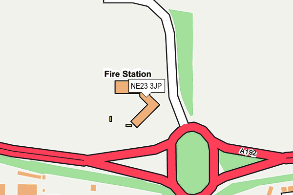
NE23 3JP is located in the Cramlington West electoral ward, within the unitary authority of Northumberland and the English Parliamentary constituency of Blyth Valley. The Sub Integrated Care Board (ICB) Location is NHS North East and North Cumbria ICB - 00L and the police force is Northumbria. This postcode has been in use since August 2010.


GetTheData
Source: OS OpenMap – Local (Ordnance Survey)
Source: OS VectorMap District (Ordnance Survey)
Licence: Open Government Licence (requires attribution)
| Easting | 425777 |
| Northing | 578949 |
| Latitude | 55.104295 |
| Longitude | -1.597551 |
GetTheData
Source: Open Postcode Geo
Licence: Open Government Licence
| Country | England |
| Postcode District | NE23 |
| ➜ NE23 open data dashboard ➜ See where NE23 is on a map | |
GetTheData
Source: Land Registry Price Paid Data
Licence: Open Government Licence
Elevation or altitude of NE23 3JP as distance above sea level:
| Metres | Feet | |
|---|---|---|
| Elevation | 50m | 164ft |
Elevation is measured from the approximate centre of the postcode, to the nearest point on an OS contour line from OS Terrain 50, which has contour spacing of ten vertical metres.
➜ How high above sea level am I? Find the elevation of your current position using your device's GPS.
GetTheData
Source: Open Postcode Elevation
Licence: Open Government Licence
| Ward | Cramlington West |
| Constituency | Blyth Valley |
GetTheData
Source: ONS Postcode Database
Licence: Open Government Licence
| January 2022 | Criminal damage and arson | On or near Dearham Grove | 455m |
| January 2022 | Violence and sexual offences | On or near Atley Way | 457m |
| September 2021 | Other crime | On or near Dearham Grove | 455m |
| ➜ Get more crime data in our Crime section | |||
GetTheData
Source: data.police.uk
Licence: Open Government Licence
| Crow Hall Lane North End (A1171) | Northburn | 344m |
| Crow Hall Lane North End (A1171) | Northburn | 350m |
| Atley Way (Nelson Way) | Cramlington Industrial Est | 546m |
| Atley Way (Nelson Way) | Cramlington Industrial Est | 564m |
| Crow Hall Lane (A1171) | Northburn | 804m |
| Cramlington Station | 1.8km |
GetTheData
Source: NaPTAN
Licence: Open Government Licence
GetTheData
Source: ONS Postcode Database
Licence: Open Government Licence


➜ Get more ratings from the Food Standards Agency
GetTheData
Source: Food Standards Agency
Licence: FSA terms & conditions
| Last Collection | |||
|---|---|---|---|
| Location | Mon-Fri | Sat | Distance |
| Horton Drive | 16:15 | 11:15 | 905m |
| Hartford Colliery Post Office | 16:00 | 11:15 | 1,019m |
| Underwood Grove | 16:15 | 11:15 | 1,075m |
GetTheData
Source: Dracos
Licence: Creative Commons Attribution-ShareAlike
| Facility | Distance |
|---|---|
| Vision Health And Fitness (Cramlington) Crow Hall Road, Nelson Park East, Cramlington Health and Fitness Gym | 619m |
| Northburn Sports And Community Centre Cramlington Sports Hall, Grass Pitches, Artificial Grass Pitch | 701m |
| East Hartford Recreation Ground Farm Road, East Hartford Grass Pitches | 935m |
GetTheData
Source: Active Places
Licence: Open Government Licence
| School | Phase of Education | Distance |
|---|---|---|
| Cramlington Northburn Primary School Horton Drive, Cramlington, NE23 3QS | Primary | 939m |
| Burnside Primary School Northumbrian Road, Cramlington, NE23 1XZ | Primary | 1.4km |
| Eastlea Primary School Skipton Close, Northburn Lea, Cramlington, NE23 3ST | Primary | 1.5km |
GetTheData
Source: Edubase
Licence: Open Government Licence
The below table lists the International Territorial Level (ITL) codes (formerly Nomenclature of Territorial Units for Statistics (NUTS) codes) and Local Administrative Units (LAU) codes for NE23 3JP:
| ITL 1 Code | Name |
|---|---|
| TLC | North East (England) |
| ITL 2 Code | Name |
| TLC2 | Northumberland, and Tyne and Wear |
| ITL 3 Code | Name |
| TLC21 | Northumberland |
| LAU 1 Code | Name |
| E06000057 | Northumberland |
GetTheData
Source: ONS Postcode Directory
Licence: Open Government Licence
The below table lists the Census Output Area (OA), Lower Layer Super Output Area (LSOA), and Middle Layer Super Output Area (MSOA) for NE23 3JP:
| Code | Name | |
|---|---|---|
| OA | E00139431 | |
| LSOA | E01027398 | Northumberland 029A |
| MSOA | E02005715 | Northumberland 029 |
GetTheData
Source: ONS Postcode Directory
Licence: Open Government Licence
| NE23 3UZ | Hauxley Drive | 398m |
| NE23 1WP | Atley Business Park | 449m |
| NE23 3FR | Dearham Grove | 466m |
| NE23 3YU | Carlby Way | 488m |
| NE23 3UY | Hartside Crescent | 529m |
| NE23 3FT | Denholm Avenue | 542m |
| NE23 3UX | Hilton Close | 549m |
| NE23 1WA | Atley Way | 556m |
| NE23 3YX | Colbury Close | 565m |
| NE23 3YT | Cheadle Avenue | 592m |
GetTheData
Source: Open Postcode Geo; Land Registry Price Paid Data
Licence: Open Government Licence