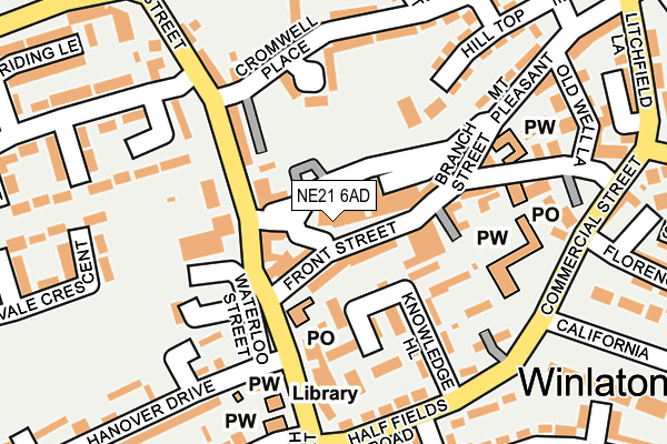
NE21 6AD lies on Front Street in Winlaton, Blaydon-on-tyne. NE21 6AD is located in the Winlaton and High Spen electoral ward, within the metropolitan district of Gateshead and the English Parliamentary constituency of Blaydon. The Sub Integrated Care Board (ICB) Location is NHS North East and North Cumbria ICB - 13T and the police force is Northumbria. This postcode has been in use since January 1980.


GetTheData
Source: OS OpenMap – Local (Ordnance Survey)
Source: OS VectorMap District (Ordnance Survey)
Licence: Open Government Licence (requires attribution)
| Easting | 417542 |
| Northing | 562259 |
| Latitude | 54.954677 |
| Longitude | -1.727631 |
GetTheData
Source: Open Postcode Geo
Licence: Open Government Licence
| Street | Front Street |
| Locality | Winlaton |
| Town/City | Blaydon-on-tyne |
| Country | England |
| Postcode District | NE21 |
| ➜ NE21 open data dashboard ➜ See where NE21 is on a map ➜ Where is Blaydon? | |
GetTheData
Source: Land Registry Price Paid Data
Licence: Open Government Licence
Elevation or altitude of NE21 6AD as distance above sea level:
| Metres | Feet | |
|---|---|---|
| Elevation | 120m | 394ft |
Elevation is measured from the approximate centre of the postcode, to the nearest point on an OS contour line from OS Terrain 50, which has contour spacing of ten vertical metres.
➜ How high above sea level am I? Find the elevation of your current position using your device's GPS.
GetTheData
Source: Open Postcode Elevation
Licence: Open Government Licence
| Ward | Winlaton And High Spen |
| Constituency | Blaydon |
GetTheData
Source: ONS Postcode Database
Licence: Open Government Licence
| January 2024 | Violence and sexual offences | On or near Parking Area | 106m |
| January 2024 | Anti-social behaviour | On or near Parking Area | 106m |
| January 2024 | Vehicle crime | On or near California | 416m |
| ➜ Front Street crime map and outcomes | |||
GetTheData
Source: data.police.uk
Licence: Open Government Licence
| North Street | Winlaton | 191m |
| North Street | Winlaton | 241m |
| Gibside View | Winlaton | 263m |
| West Lane-scotland Head (West Lane) | Winlaton | 265m |
| Scotland Head-west Lane (Scotland Head) | Winlaton | 280m |
| Blaydon Station | 1.6km |
| Metrocentre Station | 4km |
GetTheData
Source: NaPTAN
Licence: Open Government Licence
GetTheData
Source: ONS Postcode Database
Licence: Open Government Licence


➜ Get more ratings from the Food Standards Agency
GetTheData
Source: Food Standards Agency
Licence: FSA terms & conditions
| Last Collection | |||
|---|---|---|---|
| Location | Mon-Fri | Sat | Distance |
| Burn Road | 16:15 | 12:00 | 314m |
| Cromwell Avenue | 16:45 | 11:30 | 323m |
| Hanover Drive | 16:45 | 12:00 | 355m |
GetTheData
Source: Dracos
Licence: Creative Commons Attribution-ShareAlike
| Facility | Distance |
|---|---|
| Winlaton West Lane Primary School West Lane, Blaydon-on-tyne Grass Pitches | 447m |
| Winlaton Vulcans Rfc Axwell View, Blaydon-on-tyne Grass Pitches | 636m |
| Denefield Blaydon Bank, Blaydon-on-tyne Grass Pitches | 642m |
GetTheData
Source: Active Places
Licence: Open Government Licence
| School | Phase of Education | Distance |
|---|---|---|
| Winlaton West Lane Community Primary School West Lane, Winlaton, Blaydon-on-Tyne, NE21 6PH | Primary | 467m |
| Parkhead Community Primary School Park Lane, Winlaton, Blaydon-on-Tyne, NE21 6LT | Primary | 754m |
| St Thomas More Catholic School, Blaydon Croftdale Road, Blaydon-on-Tyne, NE21 4BQ | Secondary | 806m |
GetTheData
Source: Edubase
Licence: Open Government Licence
The below table lists the International Territorial Level (ITL) codes (formerly Nomenclature of Territorial Units for Statistics (NUTS) codes) and Local Administrative Units (LAU) codes for NE21 6AD:
| ITL 1 Code | Name |
|---|---|
| TLC | North East (England) |
| ITL 2 Code | Name |
| TLC2 | Northumberland, and Tyne and Wear |
| ITL 3 Code | Name |
| TLC22 | Tyneside |
| LAU 1 Code | Name |
| E08000037 | Gateshead |
GetTheData
Source: ONS Postcode Directory
Licence: Open Government Licence
The below table lists the Census Output Area (OA), Lower Layer Super Output Area (LSOA), and Middle Layer Super Output Area (MSOA) for NE21 6AD:
| Code | Name | |
|---|---|---|
| OA | E00042006 | |
| LSOA | E01008280 | Gateshead 004E |
| MSOA | E02001685 | Gateshead 004 |
GetTheData
Source: ONS Postcode Directory
Licence: Open Government Licence
| NE21 6AE | Front Street | 45m |
| NE21 6DD | The Garth | 47m |
| NE21 6BX | North Street | 87m |
| NE21 6AF | Front Street | 96m |
| NE21 6BY | North Street | 107m |
| NE21 6AB | Front Street | 117m |
| NE21 6PF | Ambrose Court | 118m |
| NE21 6AW | Church Street | 122m |
| NE21 6AL | Knowledge Hill | 126m |
| NE21 6AY | Hood Square | 131m |
GetTheData
Source: Open Postcode Geo; Land Registry Price Paid Data
Licence: Open Government Licence