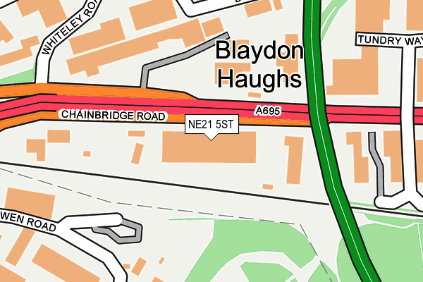
NE21 5ST lies on Chainbridge Road in Blaydon-on-tyne. NE21 5ST is located in the Blaydon electoral ward, within the metropolitan district of Gateshead and the English Parliamentary constituency of Blaydon. The Sub Integrated Care Board (ICB) Location is NHS North East and North Cumbria ICB - 13T and the police force is Northumbria. This postcode has been in use since January 1980.


GetTheData
Source: OS OpenMap – Local (Ordnance Survey)
Source: OS VectorMap District (Ordnance Survey)
Licence: Open Government Licence (requires attribution)
| Easting | 419400 |
| Northing | 563448 |
| Latitude | 54.965293 |
| Longitude | -1.698540 |
GetTheData
Source: Open Postcode Geo
Licence: Open Government Licence
| Street | Chainbridge Road |
| Town/City | Blaydon-on-tyne |
| Country | England |
| Postcode District | NE21 |
| ➜ NE21 open data dashboard ➜ See where NE21 is on a map ➜ Where is Blaydon? | |
GetTheData
Source: Land Registry Price Paid Data
Licence: Open Government Licence
Elevation or altitude of NE21 5ST as distance above sea level:
| Metres | Feet | |
|---|---|---|
| Elevation | 10m | 33ft |
Elevation is measured from the approximate centre of the postcode, to the nearest point on an OS contour line from OS Terrain 50, which has contour spacing of ten vertical metres.
➜ How high above sea level am I? Find the elevation of your current position using your device's GPS.
GetTheData
Source: Open Postcode Elevation
Licence: Open Government Licence
| Ward | Blaydon |
| Constituency | Blaydon |
GetTheData
Source: ONS Postcode Database
Licence: Open Government Licence
| January 2024 | Other theft | On or near Toll Bridge Road | 357m |
| January 2024 | Burglary | On or near Toll Bridge Road | 357m |
| January 2024 | Other theft | On or near Toll Bridge Road | 357m |
| ➜ Get more crime data in our Crime section | |||
GetTheData
Source: data.police.uk
Licence: Open Government Licence
| Chainbridge Road Industrial Estate (Chainbridge Road) | Blaydon | 161m |
| Chainbridge Road-business Park (Chainbridge Road) | Blaydon | 201m |
| Chainbridge Road-whiteley Road (Chainbridge Road) | Blaydon | 346m |
| Chainbridge Road-scotswood Bridge (Chainbridge Road) | Blaydon | 445m |
| Chainbridge Road-railway Crossing (Chainbridge Road) | Blaydon | 481m |
| Blaydon Station | 0.9km |
| Metrocentre Station | 2.2km |
| Dunston Station | 4km |
GetTheData
Source: NaPTAN
Licence: Open Government Licence
| Median download speed | 21.6Mbps |
| Average download speed | 38.1Mbps |
| Maximum download speed | 80.00Mbps |
| Median upload speed | 1.2Mbps |
| Average upload speed | 7.4Mbps |
| Maximum upload speed | 20.00Mbps |
GetTheData
Source: Ofcom
Licence: Ofcom Terms of Use (requires attribution)
GetTheData
Source: ONS Postcode Database
Licence: Open Government Licence


➜ Get more ratings from the Food Standards Agency
GetTheData
Source: Food Standards Agency
Licence: FSA terms & conditions
| Last Collection | |||
|---|---|---|---|
| Location | Mon-Fri | Sat | Distance |
| Tundry Way | 16:00 | 11:00 | 314m |
| Whiteley Road | 18:45 | 388m | |
| Factory Road | 16:15 | 11:00 | 388m |
GetTheData
Source: Dracos
Licence: Creative Commons Attribution-ShareAlike
| Facility | Distance |
|---|---|
| Inline Fitness Centre Chainbridge Road, Blaydon-on-tyne Health and Fitness Gym, Studio | 126m |
| Shibdon Road Playings Fields Shibdon Road, Blaydon Grass Pitches | 669m |
| Blaydon Youth & Community Centre Shibdon Road, Blaydon Swimming Pool, Sports Hall | 721m |
GetTheData
Source: Active Places
Licence: Open Government Licence
| School | Phase of Education | Distance |
|---|---|---|
| Blaydon West Primary School Blaydon Bank, Blaydon-on-Tyne, NE21 4PY | Primary | 1.1km |
| St George's Catholic Primary School, Bells Close Bell's Close, Newcastle-upon-Tyne, NE15 6XX | Primary | 1.1km |
| Excelsior Academy Denton Road, Newcastle-upon-Tyne, NE15 6AF | All-through | 1.2km |
GetTheData
Source: Edubase
Licence: Open Government Licence
The below table lists the International Territorial Level (ITL) codes (formerly Nomenclature of Territorial Units for Statistics (NUTS) codes) and Local Administrative Units (LAU) codes for NE21 5ST:
| ITL 1 Code | Name |
|---|---|
| TLC | North East (England) |
| ITL 2 Code | Name |
| TLC2 | Northumberland, and Tyne and Wear |
| ITL 3 Code | Name |
| TLC22 | Tyneside |
| LAU 1 Code | Name |
| E08000037 | Gateshead |
GetTheData
Source: ONS Postcode Directory
Licence: Open Government Licence
The below table lists the Census Output Area (OA), Lower Layer Super Output Area (LSOA), and Middle Layer Super Output Area (MSOA) for NE21 5ST:
| Code | Name | |
|---|---|---|
| OA | E00041460 | |
| LSOA | E01008181 | Gateshead 005C |
| MSOA | E02001686 | Gateshead 005 |
GetTheData
Source: ONS Postcode Directory
Licence: Open Government Licence
| NE21 5SZ | Chainbridge Road | 271m |
| NE21 5NH | Transbritannia Enterprise Park | 281m |
| NE21 5SJ | Tundry Way | 335m |
| NE21 5TW | Cowen Road | 390m |
| NE21 5RU | Factory Road | 521m |
| NE21 5SA | Factory Road | 538m |
| NE15 6XA | Adamsez East Industrial Estate | 576m |
| NE21 5AT | Shibdon Road | 708m |
| NE21 5BT | The Precinct | 718m |
| NE21 5LU | Shibdon Road | 727m |
GetTheData
Source: Open Postcode Geo; Land Registry Price Paid Data
Licence: Open Government Licence