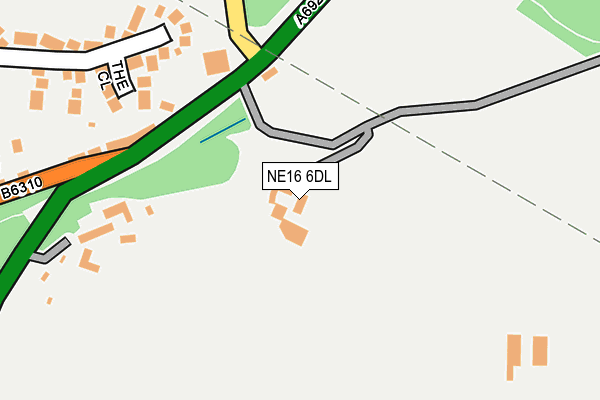
NE16 6DL is in Burnopfield, Newcastle Upon Tyne. NE16 6DL is located in the Burnopfield and Dipton electoral ward, within the unitary authority of County Durham and the English Parliamentary constituency of North West Durham. The Sub Integrated Care Board (ICB) Location is NHS North East and North Cumbria ICB - 84H and the police force is Durham. This postcode has been in use since January 1980.


GetTheData
Source: OS OpenMap – Local (Ordnance Survey)
Source: OS VectorMap District (Ordnance Survey)
Licence: Open Government Licence (requires attribution)
| Easting | 418319 |
| Northing | 556910 |
| Latitude | 54.906575 |
| Longitude | -1.715825 |
GetTheData
Source: Open Postcode Geo
Licence: Open Government Licence
| Locality | Burnopfield |
| Town/City | Newcastle Upon Tyne |
| Country | England |
| Postcode District | NE16 |
| ➜ NE16 open data dashboard ➜ See where NE16 is on a map | |
GetTheData
Source: Land Registry Price Paid Data
Licence: Open Government Licence
Elevation or altitude of NE16 6DL as distance above sea level:
| Metres | Feet | |
|---|---|---|
| Elevation | 190m | 623ft |
Elevation is measured from the approximate centre of the postcode, to the nearest point on an OS contour line from OS Terrain 50, which has contour spacing of ten vertical metres.
➜ How high above sea level am I? Find the elevation of your current position using your device's GPS.
GetTheData
Source: Open Postcode Elevation
Licence: Open Government Licence
| Ward | Burnopfield And Dipton |
| Constituency | North West Durham |
GetTheData
Source: ONS Postcode Database
Licence: Open Government Licence
| December 2021 | Violence and sexual offences | On or near Lobleyhill Road | 137m |
| November 2021 | Anti-social behaviour | On or near Lobleyhill Road | 137m |
| November 2021 | Criminal damage and arson | On or near Raglan Place | 379m |
| ➜ Get more crime data in our Crime section | |||
GetTheData
Source: data.police.uk
Licence: Open Government Licence
| Pack Horse (A692) | Crookgate | 130m |
| Pack Horse (A692) | Crookgate | 151m |
| Broom Terrace (Barcusclose Lane) | Crookgate Bank | 375m |
| Broom Terrace (Barcusclose Lane) | Crookgate Bank | 382m |
| Briar Terrace (Barcusclose Lane) | Crookgate Bank | 407m |
| Dunston Station | 6.8km |
GetTheData
Source: NaPTAN
Licence: Open Government Licence
| Percentage of properties with Next Generation Access | 100.0% |
| Percentage of properties with Superfast Broadband | 100.0% |
| Percentage of properties with Ultrafast Broadband | 0.0% |
| Percentage of properties with Full Fibre Broadband | 0.0% |
Superfast Broadband is between 30Mbps and 300Mbps
Ultrafast Broadband is > 300Mbps
| Percentage of properties unable to receive 2Mbps | 0.0% |
| Percentage of properties unable to receive 5Mbps | 0.0% |
| Percentage of properties unable to receive 10Mbps | 0.0% |
| Percentage of properties unable to receive 30Mbps | 0.0% |
GetTheData
Source: Ofcom
Licence: Ofcom Terms of Use (requires attribution)
GetTheData
Source: ONS Postcode Database
Licence: Open Government Licence


➜ Get more ratings from the Food Standards Agency
GetTheData
Source: Food Standards Agency
Licence: FSA terms & conditions
| Last Collection | |||
|---|---|---|---|
| Location | Mon-Fri | Sat | Distance |
| Oakfields | 16:15 | 10:45 | 495m |
| Burnopfield Post Office | 16:30 | 11:30 | 496m |
| Front Street | 16:00 | 10:30 | 731m |
GetTheData
Source: Dracos
Licence: Creative Commons Attribution-ShareAlike
| Facility | Distance |
|---|---|
| Sacred Heart Rc Primary School Lobley Hill Road, Byermoor, Whickham Grass Pitches | 581m |
| Crookgate The Fell, Burnopfield, Newcastle Upon Tyne Grass Pitches | 584m |
| Burnopfield Cricket Club Burnopfield, Newcastle Upon Tyne Grass Pitches | 627m |
GetTheData
Source: Active Places
Licence: Open Government Licence
| School | Phase of Education | Distance |
|---|---|---|
| Sacred Heart Catholic Primary School, Byermoor Byermoor, Burnopfield, Newcastle-upon-Tyne, NE16 6NU | Primary | 684m |
| Burnopfield Primary School Front Street, Burnopfield, Newcastle-upon-Tyne, NE16 6PT | Primary | 1.2km |
| Tanfield Lea Community Primary School Tanfield Lea, Stanley, DH9 9LU | Primary | 2.7km |
GetTheData
Source: Edubase
Licence: Open Government Licence
The below table lists the International Territorial Level (ITL) codes (formerly Nomenclature of Territorial Units for Statistics (NUTS) codes) and Local Administrative Units (LAU) codes for NE16 6DL:
| ITL 1 Code | Name |
|---|---|
| TLC | North East (England) |
| ITL 2 Code | Name |
| TLC1 | Tees Valley and Durham |
| ITL 3 Code | Name |
| TLC14 | Durham |
| LAU 1 Code | Name |
| E06000047 | County Durham |
GetTheData
Source: ONS Postcode Directory
Licence: Open Government Licence
The below table lists the Census Output Area (OA), Lower Layer Super Output Area (LSOA), and Middle Layer Super Output Area (MSOA) for NE16 6DL:
| Code | Name | |
|---|---|---|
| OA | E00104696 | |
| LSOA | E01020635 | County Durham 001B |
| MSOA | E02004297 | County Durham 001 |
GetTheData
Source: ONS Postcode Directory
Licence: Open Government Licence
| NE16 6NR | Oak Terrace | 177m |
| NE16 6LN | The Close | 221m |
| NE16 6NP | Grove Terrace | 301m |
| NE16 6NW | Chapel Avenue | 356m |
| NE16 6NN | Raglan Place | 368m |
| NE16 6DX | Briar Terrace | 403m |
| NE16 6PQ | Oakfields | 411m |
| NE16 6NF | Busty Bank | 417m |
| NE16 6DS | Broom Terrace | 424m |
| NE16 6BF | Woodland Mews | 437m |
GetTheData
Source: Open Postcode Geo; Land Registry Price Paid Data
Licence: Open Government Licence