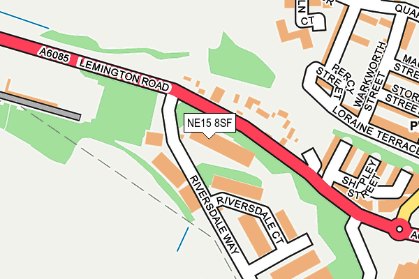
NE15 8SF is located in the Lemington electoral ward, within the metropolitan district of Newcastle upon Tyne and the English Parliamentary constituency of Newcastle upon Tyne North. The Sub Integrated Care Board (ICB) Location is NHS North East and North Cumbria ICB - 13T and the police force is Northumbria. This postcode has been in use since January 1991.


GetTheData
Source: OS OpenMap – Local (Ordnance Survey)
Source: OS VectorMap District (Ordnance Survey)
Licence: Open Government Licence (requires attribution)
| Easting | 418015 |
| Northing | 564771 |
| Latitude | 54.977226 |
| Longitude | -1.720076 |
GetTheData
Source: Open Postcode Geo
Licence: Open Government Licence
| Country | England |
| Postcode District | NE15 |
| ➜ NE15 open data dashboard ➜ See where NE15 is on a map ➜ Where is Newcastle upon Tyne? | |
GetTheData
Source: Land Registry Price Paid Data
Licence: Open Government Licence
Elevation or altitude of NE15 8SF as distance above sea level:
| Metres | Feet | |
|---|---|---|
| Elevation | 10m | 33ft |
Elevation is measured from the approximate centre of the postcode, to the nearest point on an OS contour line from OS Terrain 50, which has contour spacing of ten vertical metres.
➜ How high above sea level am I? Find the elevation of your current position using your device's GPS.
GetTheData
Source: Open Postcode Elevation
Licence: Open Government Licence
| Ward | Lemington |
| Constituency | Newcastle Upon Tyne North |
GetTheData
Source: ONS Postcode Database
Licence: Open Government Licence
| December 2023 | Burglary | On or near Quarry Road | 335m |
| September 2023 | Violence and sexual offences | On or near Quarry Road | 335m |
| July 2023 | Possession of weapons | On or near Blyth Court | 306m |
| ➜ Get more crime data in our Crime section | |||
GetTheData
Source: data.police.uk
Licence: Open Government Licence
| Lemington Road-riverside Way (Lemington Road) | Lemington | 56m |
| Lemington Road-riverside Way (Lemington Road) | Lemington | 64m |
| Northumberland Road | Lemington | 214m |
| Aln Court - Wansbeck House (Aln Court) | Lemington | 219m |
| Northumberland Road | Lemington | 302m |
| Blaydon Station | 1.4km |
| Metrocentre Station | 4km |
GetTheData
Source: NaPTAN
Licence: Open Government Licence
GetTheData
Source: ONS Postcode Database
Licence: Open Government Licence


➜ Get more ratings from the Food Standards Agency
GetTheData
Source: Food Standards Agency
Licence: FSA terms & conditions
| Last Collection | |||
|---|---|---|---|
| Location | Mon-Fri | Sat | Distance |
| Moorcroft Road | 17:30 | 11:30 | 854m |
| Stella Hall Drive | 16:00 | 11:00 | 1,076m |
| Stella Road | 16:00 | 12:00 | 1,151m |
GetTheData
Source: Dracos
Licence: Creative Commons Attribution-ShareAlike
| Facility | Distance |
|---|---|
| Valley View Pavilion Valley View, Lemington, Newcastle Upon Tyne Grass Pitches | 504m |
| Waverley Primary School Maple Close, Newcastle Upon Tyne Grass Pitches | 1.1km |
| Lemington Football Centre West Denton Road, Lemington, Newcastle Upon Tyne Grass Pitches | 1.2km |
GetTheData
Source: Active Places
Licence: Open Government Licence
| School | Phase of Education | Distance |
|---|---|---|
| Lemington Riverside Primary School Rokeby Street, Lemington, Newcastle-upon-Tyne, NE15 8RR | Primary | 635m |
| St George's Catholic Primary School, Bells Close Bell's Close, Newcastle-upon-Tyne, NE15 6XX | Primary | 984m |
| Waverley Primary School Maple Close, Lemington, Newcastle-upon-Tyne, NE15 7QZ | Primary | 1.1km |
GetTheData
Source: Edubase
Licence: Open Government Licence
The below table lists the International Territorial Level (ITL) codes (formerly Nomenclature of Territorial Units for Statistics (NUTS) codes) and Local Administrative Units (LAU) codes for NE15 8SF:
| ITL 1 Code | Name |
|---|---|
| TLC | North East (England) |
| ITL 2 Code | Name |
| TLC2 | Northumberland, and Tyne and Wear |
| ITL 3 Code | Name |
| TLC22 | Tyneside |
| LAU 1 Code | Name |
| E08000021 | Newcastle upon Tyne |
GetTheData
Source: ONS Postcode Directory
Licence: Open Government Licence
The below table lists the Census Output Area (OA), Lower Layer Super Output Area (LSOA), and Middle Layer Super Output Area (MSOA) for NE15 8SF:
| Code | Name | |
|---|---|---|
| OA | E00042538 | |
| LSOA | E01008387 | Newcastle upon Tyne 021G |
| MSOA | E02001728 | Newcastle upon Tyne 021 |
GetTheData
Source: ONS Postcode Directory
Licence: Open Government Licence
| NE15 8SN | Hulne Terrace | 172m |
| NE15 8SP | Beanley Avenue | 217m |
| NE15 8EL | Tynevale Terrace | 229m |
| NE15 8EA | Loraine Terrace | 230m |
| NE15 8SD | Northumberland Road | 242m |
| NE15 8ER | Aln Court | 243m |
| NE15 8SQ | Denwick Avenue | 247m |
| NE15 8DX | Warkworth Street | 251m |
| NE15 8SR | Shipley Street | 262m |
| NE15 8SL | Northumberland Road | 268m |
GetTheData
Source: Open Postcode Geo; Land Registry Price Paid Data
Licence: Open Government Licence