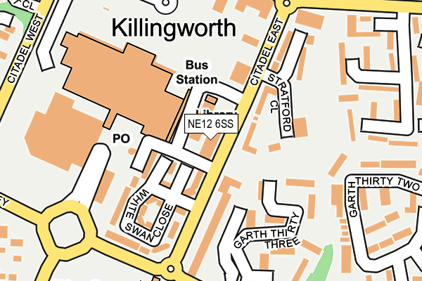
NE12 6SS is located in the Killingworth electoral ward, within the metropolitan district of North Tyneside and the English Parliamentary constituency of North Tyneside. The Sub Integrated Care Board (ICB) Location is NHS North East and North Cumbria ICB - 99C and the police force is Northumbria. This postcode has been in use since December 1999.


GetTheData
Source: OS OpenMap – Local (Ordnance Survey)
Source: OS VectorMap District (Ordnance Survey)
Licence: Open Government Licence (requires attribution)
| Easting | 427891 |
| Northing | 571354 |
| Latitude | 55.035935 |
| Longitude | -1.565159 |
GetTheData
Source: Open Postcode Geo
Licence: Open Government Licence
| Country | England |
| Postcode District | NE12 |
| ➜ NE12 open data dashboard ➜ See where NE12 is on a map ➜ Where is Killingworth? | |
GetTheData
Source: Land Registry Price Paid Data
Licence: Open Government Licence
Elevation or altitude of NE12 6SS as distance above sea level:
| Metres | Feet | |
|---|---|---|
| Elevation | 70m | 230ft |
Elevation is measured from the approximate centre of the postcode, to the nearest point on an OS contour line from OS Terrain 50, which has contour spacing of ten vertical metres.
➜ How high above sea level am I? Find the elevation of your current position using your device's GPS.
GetTheData
Source: Open Postcode Elevation
Licence: Open Government Licence
| Ward | Killingworth |
| Constituency | North Tyneside |
GetTheData
Source: ONS Postcode Database
Licence: Open Government Licence
| June 2022 | Shoplifting | On or near Stratford Close | 113m |
| June 2022 | Shoplifting | On or near Stratford Close | 113m |
| June 2022 | Shoplifting | On or near Stratford Close | 113m |
| ➜ Get more crime data in our Crime section | |||
GetTheData
Source: data.police.uk
Licence: Open Government Licence
| East Bailey-garth 20 (East Bailey) | Killingworth | 259m |
| East Bailey-garth 33 (East Bailey) | Killingworth | 260m |
| East Bailey - Garth 33 (East Bailey) | Killingworth | 268m |
| East Bailey-garth 20 (East Bailey) | Killingworth | 286m |
| Citadel West - West Mount Estate (Citadel West) | Killingworth | 297m |
GetTheData
Source: NaPTAN
Licence: Open Government Licence
GetTheData
Source: ONS Postcode Database
Licence: Open Government Licence


➜ Get more ratings from the Food Standards Agency
GetTheData
Source: Food Standards Agency
Licence: FSA terms & conditions
| Last Collection | |||
|---|---|---|---|
| Location | Mon-Fri | Sat | Distance |
| Killingworth Post Office | 17:30 | 12:00 | 139m |
| Garth 21 | 17:30 | 12:00 | 383m |
| West Lane | 17:30 | 12:15 | 479m |
GetTheData
Source: Dracos
Licence: Creative Commons Attribution-ShareAlike
| Facility | Distance |
|---|---|
| White Swan Centre Citadel East, Newcastle Upon Tyne Sports Hall, Health and Fitness Gym | 44m |
| Amberley Primary School East Bailey, Newcastle Upon Tyne Grass Pitches | 268m |
| George Stephenson High School Southgate, Newcastle Upon Tyne Grass Pitches, Sports Hall, Outdoor Tennis Courts | 327m |
GetTheData
Source: Active Places
Licence: Open Government Licence
| School | Phase of Education | Distance |
|---|---|---|
| Amberley Primary School East Bailey, Killingworth, Newcastle-upon-Tyne, NE12 6SQ | Primary | 259m |
| George Stephenson High School Southgate, Killingworth, Newcastle-upon-Tyne, NE12 6SA | Secondary | 331m |
| Bailey Green Primary School West Bailey, Killingworth, NE12 6QL | Primary | 591m |
GetTheData
Source: Edubase
Licence: Open Government Licence
The below table lists the International Territorial Level (ITL) codes (formerly Nomenclature of Territorial Units for Statistics (NUTS) codes) and Local Administrative Units (LAU) codes for NE12 6SS:
| ITL 1 Code | Name |
|---|---|
| TLC | North East (England) |
| ITL 2 Code | Name |
| TLC2 | Northumberland, and Tyne and Wear |
| ITL 3 Code | Name |
| TLC22 | Tyneside |
| LAU 1 Code | Name |
| E08000022 | North Tyneside |
GetTheData
Source: ONS Postcode Directory
Licence: Open Government Licence
The below table lists the Census Output Area (OA), Lower Layer Super Output Area (LSOA), and Middle Layer Super Output Area (MSOA) for NE12 6SS:
| Code | Name | |
|---|---|---|
| OA | E00043142 | |
| LSOA | E01008505 | North Tyneside 012B |
| MSOA | E02001749 | North Tyneside 012 |
GetTheData
Source: ONS Postcode Directory
Licence: Open Government Licence
| NE12 6DL | Citadel East | 70m |
| NE12 6YT | The Killingworth Centre | 104m |
| NE12 6UH | White Swan Close | 106m |
| NE12 6DB | Hadrian Court | 139m |
| NE12 6DD | Hadrian Court | 157m |
| NE12 6DE | Hadrian Court | 157m |
| NE12 6DF | Hadrian Court | 157m |
| NE12 6GU | Stratford Close | 161m |
| NE12 6BZ | Hadrian Court | 170m |
| NE12 6UG | White Swan Close | 189m |
GetTheData
Source: Open Postcode Geo; Land Registry Price Paid Data
Licence: Open Government Licence