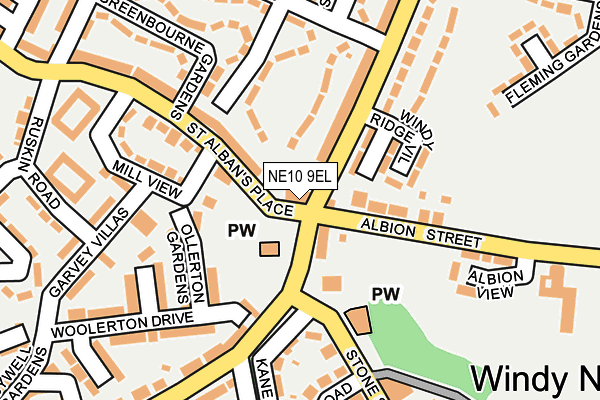
NE10 9EL is located in the Windy Nook and Whitehills electoral ward, within the metropolitan district of Gateshead and the English Parliamentary constituency of Gateshead. The Sub Integrated Care Board (ICB) Location is NHS North East and North Cumbria ICB - 13T and the police force is Northumbria. This postcode has been in use since January 1980.


GetTheData
Source: OS OpenMap – Local (Ordnance Survey)
Source: OS VectorMap District (Ordnance Survey)
Licence: Open Government Licence (requires attribution)
| Easting | 427242 |
| Northing | 561014 |
| Latitude | 54.943049 |
| Longitude | -1.576278 |
GetTheData
Source: Open Postcode Geo
Licence: Open Government Licence
| Country | England |
| Postcode District | NE10 |
| ➜ NE10 open data dashboard ➜ See where NE10 is on a map ➜ Where is Gateshead? | |
GetTheData
Source: Land Registry Price Paid Data
Licence: Open Government Licence
Elevation or altitude of NE10 9EL as distance above sea level:
| Metres | Feet | |
|---|---|---|
| Elevation | 130m | 427ft |
Elevation is measured from the approximate centre of the postcode, to the nearest point on an OS contour line from OS Terrain 50, which has contour spacing of ten vertical metres.
➜ How high above sea level am I? Find the elevation of your current position using your device's GPS.
GetTheData
Source: Open Postcode Elevation
Licence: Open Government Licence
| Ward | Windy Nook And Whitehills |
| Constituency | Gateshead |
GetTheData
Source: ONS Postcode Database
Licence: Open Government Licence
| January 2024 | Other theft | On or near St Alban'S Place | 70m |
| January 2024 | Anti-social behaviour | On or near St Alban'S Place | 70m |
| January 2024 | Anti-social behaviour | On or near Kane Gardens | 234m |
| ➜ Get more crime data in our Crime section | |||
GetTheData
Source: data.police.uk
Licence: Open Government Licence
| Coldwell Lane - Albion Street (Coldwell Lane) | Windy Nook | 21m |
| St Albans Place (Carr Hill Road) | Windy Nook | 42m |
| Windy Nook Road - Stone Street (Windy Nook Road) | Windy Nook | 59m |
| Albion Street | Windy Nook | 80m |
| Windy Nook Road - Stone Street (Windy Nook Road) | Windy Nook | 83m |
| Felling (Tyne And Wear Metro Station) (Mulberry Street) | Felling | 1,149m |
| Heworth (Tyne And Wear Metro Station) (Abbotsford Road (Felling By-pass)) | Heworth | 1,662m |
| Heworth Station | 1.6km |
| Manors Station | 3.8km |
| Newcastle Station | 3.9km |
GetTheData
Source: NaPTAN
Licence: Open Government Licence
GetTheData
Source: ONS Postcode Database
Licence: Open Government Licence


➜ Get more ratings from the Food Standards Agency
GetTheData
Source: Food Standards Agency
Licence: FSA terms & conditions
| Last Collection | |||
|---|---|---|---|
| Location | Mon-Fri | Sat | Distance |
| Coldwell Lane | 16:45 | 11:30 | 56m |
| Rectory Road | 17:30 | 11:30 | 304m |
| Carr Hill Post Office | 17:00 | 12:00 | 502m |
GetTheData
Source: Dracos
Licence: Creative Commons Attribution-ShareAlike
| Facility | Distance |
|---|---|
| Carr Hill Reservoir Causeway, Gateshead Grass Pitches | 487m |
| Furrowfield School Whitehill Drive, Gateshead Grass Pitches, Health and Fitness Gym, Sports Hall | 524m |
| Albion Street Windy Nook, Gateshead Grass Pitches | 601m |
GetTheData
Source: Active Places
Licence: Open Government Licence
| School | Phase of Education | Distance |
|---|---|---|
| Furrowfield School Whitehill Drive, Felling, Gateshead, NE10 9RZ | Not applicable | 581m |
| Windy Nook Primary School Albion Street, Gateshead, NE10 9BD | Primary | 600m |
| Carr Hill Community Primary School Carr Hill Road, Gateshead, NE9 5NB | Primary | 610m |
GetTheData
Source: Edubase
Licence: Open Government Licence
The below table lists the International Territorial Level (ITL) codes (formerly Nomenclature of Territorial Units for Statistics (NUTS) codes) and Local Administrative Units (LAU) codes for NE10 9EL:
| ITL 1 Code | Name |
|---|---|
| TLC | North East (England) |
| ITL 2 Code | Name |
| TLC2 | Northumberland, and Tyne and Wear |
| ITL 3 Code | Name |
| TLC22 | Tyneside |
| LAU 1 Code | Name |
| E08000037 | Gateshead |
GetTheData
Source: ONS Postcode Directory
Licence: Open Government Licence
The below table lists the Census Output Area (OA), Lower Layer Super Output Area (LSOA), and Middle Layer Super Output Area (MSOA) for NE10 9EL:
| Code | Name | |
|---|---|---|
| OA | E00041747 | |
| LSOA | E01008228 | Gateshead 012D |
| MSOA | E02001693 | Gateshead 012 |
GetTheData
Source: ONS Postcode Directory
Licence: Open Government Licence
| NE10 9SQ | Cooperative Crescent | 88m |
| NE10 9TP | Oxberry Gardens | 99m |
| NE10 9BT | Cooperative Terrace | 106m |
| NE10 9SP | St Albans Place | 114m |
| NE10 9AF | Church Mews | 116m |
| NE10 9DD | Windyridge Villas | 117m |
| NE10 9RT | Ollerton Gardens | 135m |
| NE10 9DB | Doddington Villas | 158m |
| NE10 9SU | Mill View | 164m |
| NE10 9RS | Lanercost Gardens | 165m |
GetTheData
Source: Open Postcode Geo; Land Registry Price Paid Data
Licence: Open Government Licence