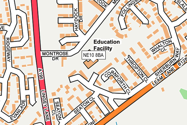
NE10 8BA is located in the Wardley and Leam Lane electoral ward, within the metropolitan district of Gateshead and the English Parliamentary constituency of Jarrow. The Sub Integrated Care Board (ICB) Location is NHS North East and North Cumbria ICB - 13T and the police force is Northumbria. This postcode has been in use since January 1980.


GetTheData
Source: OS OpenMap – Local (Ordnance Survey)
Source: OS VectorMap District (Ordnance Survey)
Licence: Open Government Licence (requires attribution)
| Easting | 430075 |
| Northing | 560960 |
| Latitude | 54.942402 |
| Longitude | -1.532062 |
GetTheData
Source: Open Postcode Geo
Licence: Open Government Licence
| Country | England |
| Postcode District | NE10 |
| ➜ NE10 open data dashboard ➜ See where NE10 is on a map ➜ Where is Gateshead? | |
GetTheData
Source: Land Registry Price Paid Data
Licence: Open Government Licence
Elevation or altitude of NE10 8BA as distance above sea level:
| Metres | Feet | |
|---|---|---|
| Elevation | 60m | 197ft |
Elevation is measured from the approximate centre of the postcode, to the nearest point on an OS contour line from OS Terrain 50, which has contour spacing of ten vertical metres.
➜ How high above sea level am I? Find the elevation of your current position using your device's GPS.
GetTheData
Source: Open Postcode Elevation
Licence: Open Government Licence
| Ward | Wardley And Leam Lane |
| Constituency | Jarrow |
GetTheData
Source: ONS Postcode Database
Licence: Open Government Licence
| June 2022 | Violence and sexual offences | On or near Lanchester Close | 138m |
| June 2022 | Violence and sexual offences | On or near Seaton Close | 171m |
| June 2022 | Violence and sexual offences | On or near Sherburn Way | 273m |
| ➜ Get more crime data in our Crime section | |||
GetTheData
Source: data.police.uk
Licence: Open Government Licence
| Lingey Lane-montrose Drive (Lingey Lane) | Leam Lane | 173m |
| Sherburn Way (Leam Lane) | Leam Lane | 179m |
| Lingey Lane-montrose Drive (Lingley Lane) | Leam Lane | 187m |
| Lingey Lane-langley Avenue (Lingey Lane) | Leam Lane | 288m |
| Lingey Lane-st Georges Court (Lingey Lane) | Leam Lane | 330m |
| Pelaw (Tyne And Wear Metro Station) (Pelaw Way) | Pelaw | 1,325m |
| Heworth (Tyne And Wear Metro Station) (Abbotsford Road (Felling By-pass)) | Heworth | 1,800m |
| Heworth Station | 1.8km |
| Brockley Whins Station | 4.9km |
| Manors Station | 5.8km |
GetTheData
Source: NaPTAN
Licence: Open Government Licence
GetTheData
Source: ONS Postcode Database
Licence: Open Government Licence


➜ Get more ratings from the Food Standards Agency
GetTheData
Source: Food Standards Agency
Licence: FSA terms & conditions
| Last Collection | |||
|---|---|---|---|
| Location | Mon-Fri | Sat | Distance |
| Lanchester Close | 16:30 | 10:30 | 166m |
| Meadowbrook Drive | 16:30 | 10:30 | 245m |
| Millford | 17:00 | 10:30 | 403m |
GetTheData
Source: Dracos
Licence: Creative Commons Attribution-ShareAlike
| Facility | Distance |
|---|---|
| White Mere Community Primary School Leam Lane, Gateshead Grass Pitches | 0m |
| Heworth Golf Club Ltd Heworth, Gateshead Golf | 285m |
| Oliver Henderson Park Millford, Gateshead Grass Pitches | 448m |
GetTheData
Source: Active Places
Licence: Open Government Licence
| School | Phase of Education | Distance |
|---|---|---|
| White Mere Community Primary School Sherburn Way, Wardley, Gateshead, NE10 8BA | Primary | 6m |
| Lingey House Primary School Millford, Leam Lane Estate, Felling, Gateshead, NE10 8DN | Primary | 492m |
| Wardley Primary School Keir Hardie Avenue, Wardley, Gateshead, NE10 8TX | Primary | 1km |
GetTheData
Source: Edubase
Licence: Open Government Licence
The below table lists the International Territorial Level (ITL) codes (formerly Nomenclature of Territorial Units for Statistics (NUTS) codes) and Local Administrative Units (LAU) codes for NE10 8BA:
| ITL 1 Code | Name |
|---|---|
| TLC | North East (England) |
| ITL 2 Code | Name |
| TLC2 | Northumberland, and Tyne and Wear |
| ITL 3 Code | Name |
| TLC22 | Tyneside |
| LAU 1 Code | Name |
| E08000037 | Gateshead |
GetTheData
Source: ONS Postcode Directory
Licence: Open Government Licence
The below table lists the Census Output Area (OA), Lower Layer Super Output Area (LSOA), and Middle Layer Super Output Area (MSOA) for NE10 8BA:
| Code | Name | |
|---|---|---|
| OA | E00042034 | |
| LSOA | E01008284 | Gateshead 014B |
| MSOA | E02001695 | Gateshead 014 |
GetTheData
Source: ONS Postcode Directory
Licence: Open Government Licence
| NE10 8SN | Cornforth Close | 72m |
| NE10 8RZ | Sherburn Way | 85m |
| NE10 8BZ | Ashridge Court | 97m |
| NE10 8DY | Carnoustie Court | 103m |
| NE10 8SQ | Sherburn Way | 110m |
| NE10 8RG | Sherburn Way | 132m |
| NE10 8SP | Thropton Close | 137m |
| NE10 8DF | Turnberry Court | 148m |
| NE10 8SG | Seaton Close | 153m |
| NE10 8RF | Lanchester Close | 155m |
GetTheData
Source: Open Postcode Geo; Land Registry Price Paid Data
Licence: Open Government Licence