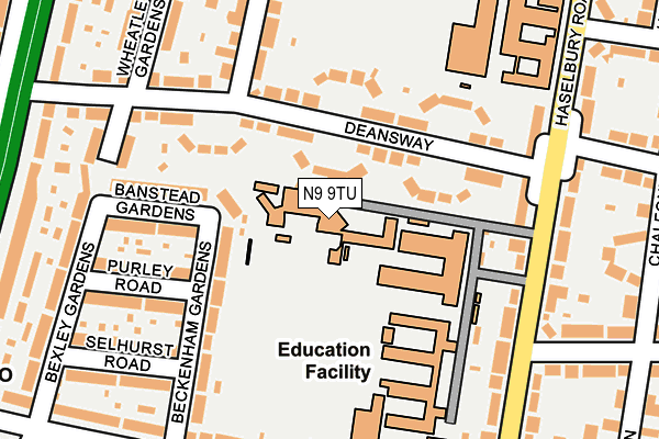
N9 9TU is located in the Haselbury electoral ward, within the London borough of Enfield and the English Parliamentary constituency of Edmonton. The Sub Integrated Care Board (ICB) Location is NHS North Central London ICB - 93C and the police force is Metropolitan Police. This postcode has been in use since January 1980.


GetTheData
Source: OS OpenMap – Local (Ordnance Survey)
Source: OS VectorMap District (Ordnance Survey)
Licence: Open Government Licence (requires attribution)
| Easting | 533196 |
| Northing | 193376 |
| Latitude | 51.623448 |
| Longitude | -0.077270 |
GetTheData
Source: Open Postcode Geo
Licence: Open Government Licence
| Country | England |
| Postcode District | N9 |
| ➜ N9 open data dashboard ➜ See where N9 is on a map ➜ Where is Edmonton? | |
GetTheData
Source: Land Registry Price Paid Data
Licence: Open Government Licence
Elevation or altitude of N9 9TU as distance above sea level:
| Metres | Feet | |
|---|---|---|
| Elevation | 20m | 66ft |
Elevation is measured from the approximate centre of the postcode, to the nearest point on an OS contour line from OS Terrain 50, which has contour spacing of ten vertical metres.
➜ How high above sea level am I? Find the elevation of your current position using your device's GPS.
GetTheData
Source: Open Postcode Elevation
Licence: Open Government Licence
| Ward | Haselbury |
| Constituency | Edmonton |
GetTheData
Source: ONS Postcode Database
Licence: Open Government Licence
| January 2024 | Possession of weapons | On or near Perry Gardens | 213m |
| January 2024 | Drugs | On or near Keston Close | 376m |
| December 2023 | Anti-social behaviour | On or near Perry Gardens | 213m |
| ➜ Get more crime data in our Crime section | |||
GetTheData
Source: data.police.uk
Licence: Open Government Licence
| Haselbury Road | Lower Edmonton | 196m |
| Northern Avenue (Haselbury Road) | Lower Edmonton | 252m |
| Deansway (N9) | Lower Edmonton | 288m |
| Deansway (N9) | Lower Edmonton | 348m |
| The Fairway (N18) | Edmonton | 369m |
| Edmonton Green Station | 1.1km |
| Silver Street Station | 1.2km |
| Winchmore Hill Station | 2km |
GetTheData
Source: NaPTAN
Licence: Open Government Licence
GetTheData
Source: ONS Postcode Database
Licence: Open Government Licence


➜ Get more ratings from the Food Standards Agency
GetTheData
Source: Food Standards Agency
Licence: FSA terms & conditions
| Last Collection | |||
|---|---|---|---|
| Location | Mon-Fri | Sat | Distance |
| 1a Westerham Avenue | 17:30 | 12:00 | 368m |
| Haslebury Rd/Huxley Road | 17:30 | 12:00 | 485m |
| Harlow Road/The Fairway | 17:30 | 12:00 | 626m |
GetTheData
Source: Dracos
Licence: Creative Commons Attribution-ShareAlike
| Facility | Distance |
|---|---|
| West Lea School Haselbury Road, London Grass Pitches | 0m |
| The Latymer School Haselbury Road, London Sports Hall, Health and Fitness Gym, Grass Pitches, Outdoor Tennis Courts, Artificial Grass Pitch | 269m |
| Church Street Recreation Ground Great Cambridge Road, Edmonton Grass Pitches | 431m |
GetTheData
Source: Active Places
Licence: Open Government Licence
| School | Phase of Education | Distance |
|---|---|---|
| West Lea School Haselbury Road, Edmonton, London, N9 9TU | Not applicable | 64m |
| Hazelbury Primary School Haselbury Road, Edmonton, London, N9 9TT | Primary | 123m |
| The Latymer School Haselbury Road, London, N9 9TN | Secondary | 359m |
GetTheData
Source: Edubase
Licence: Open Government Licence
The below table lists the International Territorial Level (ITL) codes (formerly Nomenclature of Territorial Units for Statistics (NUTS) codes) and Local Administrative Units (LAU) codes for N9 9TU:
| ITL 1 Code | Name |
|---|---|
| TLI | London |
| ITL 2 Code | Name |
| TLI5 | Outer London - East and North East |
| ITL 3 Code | Name |
| TLI54 | Enfield |
| LAU 1 Code | Name |
| E09000010 | Enfield |
GetTheData
Source: ONS Postcode Directory
Licence: Open Government Licence
The below table lists the Census Output Area (OA), Lower Layer Super Output Area (LSOA), and Middle Layer Super Output Area (MSOA) for N9 9TU:
| Code | Name | |
|---|---|---|
| OA | E00007257 | |
| LSOA | E01001464 | Enfield 027E |
| MSOA | E02000303 | Enfield 027 |
GetTheData
Source: ONS Postcode Directory
Licence: Open Government Licence
| N9 9TX | Deansway | 75m |
| N9 9TZ | Deansway | 106m |
| N9 9BZ | Beckenham Gardens | 134m |
| N9 9BY | Banstead Gardens | 162m |
| N9 9DA | Purley Road | 176m |
| N9 9TY | Deansway | 178m |
| N9 9TT | Haselbury Road | 193m |
| N9 9UT | Perry Gardens | 197m |
| N9 9UD | Deansway | 203m |
| N9 9TL | Haselbury Road | 203m |
GetTheData
Source: Open Postcode Geo; Land Registry Price Paid Data
Licence: Open Government Licence