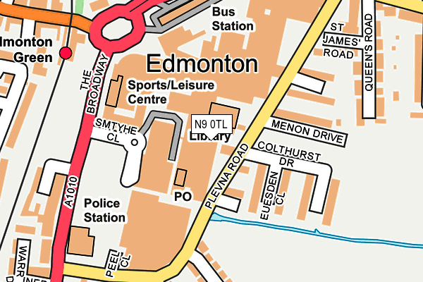
N9 0TL is located in the Edmonton Green electoral ward, within the London borough of Enfield and the English Parliamentary constituency of Edmonton. The Sub Integrated Care Board (ICB) Location is NHS North Central London ICB - 93C and the police force is Metropolitan Police. This postcode has been in use since January 1980.


GetTheData
Source: OS OpenMap – Local (Ordnance Survey)
Source: OS VectorMap District (Ordnance Survey)
Licence: Open Government Licence (requires attribution)
| Easting | 534505 |
| Northing | 193424 |
| Latitude | 51.623569 |
| Longitude | -0.058353 |
GetTheData
Source: Open Postcode Geo
Licence: Open Government Licence
| Country | England |
| Postcode District | N9 |
| ➜ N9 open data dashboard ➜ See where N9 is on a map ➜ Where is Edmonton? | |
GetTheData
Source: Land Registry Price Paid Data
Licence: Open Government Licence
Elevation or altitude of N9 0TL as distance above sea level:
| Metres | Feet | |
|---|---|---|
| Elevation | 10m | 33ft |
Elevation is measured from the approximate centre of the postcode, to the nearest point on an OS contour line from OS Terrain 50, which has contour spacing of ten vertical metres.
➜ How high above sea level am I? Find the elevation of your current position using your device's GPS.
GetTheData
Source: Open Postcode Elevation
Licence: Open Government Licence
| Ward | Edmonton Green |
| Constituency | Edmonton |
GetTheData
Source: ONS Postcode Database
Licence: Open Government Licence
| January 2024 | Violence and sexual offences | On or near Parking Area | 370m |
| January 2024 | Anti-social behaviour | On or near Barbot Close | 427m |
| January 2024 | Anti-social behaviour | On or near Barbot Close | 427m |
| ➜ Get more crime data in our Crime section | |||
GetTheData
Source: data.police.uk
Licence: Open Government Licence
| Asda Edmonton Green | Lower Edmonton | 35m |
| Asda Edmonton Green | Lower Edmonton | 70m |
| Edmonton Green Bus Station | Lower Edmonton | 181m |
| Edmonton Green Station (The Broadway) | Lower Edmonton | 186m |
| Edmonton Green Bus Station | Lower Edmonton | 192m |
| Edmonton Green Station | 0.2km |
| Silver Street Station | 1.2km |
| Angel Road Station | 1.4km |
GetTheData
Source: NaPTAN
Licence: Open Government Licence
GetTheData
Source: ONS Postcode Database
Licence: Open Government Licence
➜ Get more ratings from the Food Standards Agency
GetTheData
Source: Food Standards Agency
Licence: FSA terms & conditions
| Last Collection | |||
|---|---|---|---|
| Location | Mon-Fri | Sat | Distance |
| Lower Edmonton Delivery Office | 18:30 | 12:00 | 161m |
| 393 Fore Street | 17:30 | 12:00 | 222m |
| The Green | 17:30 | 12:00 | 238m |
GetTheData
Source: Dracos
Licence: Creative Commons Attribution-ShareAlike
| Facility | Distance |
|---|---|
| Edmonton Leisure Centre (Closed) Plevna Road, London Studio, Swimming Pool, Health and Fitness Gym, Squash Courts | 143m |
| Edmonton Leisure Centre The Broadway, London Sports Hall, Swimming Pool, Health and Fitness Gym, Studio | 159m |
| The Gym Group (London Edmonton Green) North Mall, London Health and Fitness Gym | 249m |
GetTheData
Source: Active Places
Licence: Open Government Licence
| School | Phase of Education | Distance |
|---|---|---|
| Alternative Centre of Education 45/51 Market Square, Edmonton Green, London, London, N9 0TZ | Not applicable | 80m |
| Fleecefield Primary School Brettenham Road, London, N18 2ES | Primary | 589m |
| Brettenham Primary School Brettenham Road, London, N18 2ET | Primary | 637m |
GetTheData
Source: Edubase
Licence: Open Government Licence
The below table lists the International Territorial Level (ITL) codes (formerly Nomenclature of Territorial Units for Statistics (NUTS) codes) and Local Administrative Units (LAU) codes for N9 0TL:
| ITL 1 Code | Name |
|---|---|
| TLI | London |
| ITL 2 Code | Name |
| TLI5 | Outer London - East and North East |
| ITL 3 Code | Name |
| TLI54 | Enfield |
| LAU 1 Code | Name |
| E09000010 | Enfield |
GetTheData
Source: ONS Postcode Directory
Licence: Open Government Licence
The below table lists the Census Output Area (OA), Lower Layer Super Output Area (LSOA), and Middle Layer Super Output Area (MSOA) for N9 0TL:
| Code | Name | |
|---|---|---|
| OA | E00171141 | |
| LSOA | E01001429 | Enfield 030D |
| MSOA | E02000306 | Enfield 030 |
GetTheData
Source: ONS Postcode Directory
Licence: Open Government Licence
| N9 0TE | South Mall | 0m |
| N9 0TG | South Mall | 0m |
| N9 0GP | Clarke Mews | 76m |
| N9 0GG | Colthurst Drive | 79m |
| N9 0GN | Euesden Close | 95m |
| N9 0TY | The Concourse | 128m |
| N9 0TP | The Broadway | 155m |
| N9 0TQ | The Concourse | 155m |
| N9 0GA | Summerskille Close | 155m |
| N9 0GE | Menon Drive | 164m |
GetTheData
Source: Open Postcode Geo; Land Registry Price Paid Data
Licence: Open Government Licence