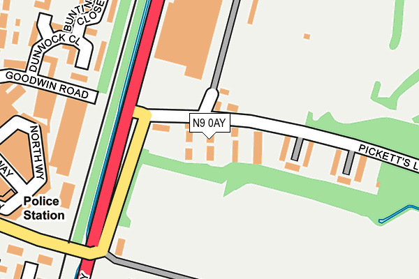
N9 0AY lies on Picketts Lock Lane in London. N9 0AY is located in the Lower Edmonton electoral ward, within the London borough of Enfield and the English Parliamentary constituency of Edmonton. The Sub Integrated Care Board (ICB) Location is NHS North Central London ICB - 93C and the police force is Metropolitan Police. This postcode has been in use since January 1980.


GetTheData
Source: OS OpenMap – Local (Ordnance Survey)
Source: OS VectorMap District (Ordnance Survey)
Licence: Open Government Licence (requires attribution)
| Easting | 535797 |
| Northing | 193940 |
| Latitude | 51.627895 |
| Longitude | -0.039501 |
GetTheData
Source: Open Postcode Geo
Licence: Open Government Licence
| Street | Picketts Lock Lane |
| Town/City | London |
| Country | England |
| Postcode District | N9 |
➜ See where N9 is on a map ➜ Where is Edmonton? | |
GetTheData
Source: Land Registry Price Paid Data
Licence: Open Government Licence
Elevation or altitude of N9 0AY as distance above sea level:
| Metres | Feet | |
|---|---|---|
| Elevation | 10m | 33ft |
Elevation is measured from the approximate centre of the postcode, to the nearest point on an OS contour line from OS Terrain 50, which has contour spacing of ten vertical metres.
➜ How high above sea level am I? Find the elevation of your current position using your device's GPS.
GetTheData
Source: Open Postcode Elevation
Licence: Open Government Licence
| Ward | Lower Edmonton |
| Constituency | Edmonton |
GetTheData
Source: ONS Postcode Database
Licence: Open Government Licence
26A, PICKETTS LOCK LANE, LONDON, N9 0AY 2004 10 MAR £85,000 |
GetTheData
Source: HM Land Registry Price Paid Data
Licence: Contains HM Land Registry data © Crown copyright and database right 2025. This data is licensed under the Open Government Licence v3.0.
| Meridian Way | Lower Edmonton | 107m |
| Meridian Way | Lower Edmonton | 157m |
| Pentland Close | Lower Edmonton | 315m |
| Montagu Road Lower Edmonton | Lower Edmonton | 325m |
| St Mary's Roadnightingale Rd (Nightingale Road) | Lower Edmonton | 416m |
| Edmonton Green Station | 1.5km |
| Ponders End Station | 1.6km |
| Angel Road Station | 1.8km |
GetTheData
Source: NaPTAN
Licence: Open Government Licence
| Percentage of properties with Next Generation Access | 21.7% |
| Percentage of properties with Superfast Broadband | 21.7% |
| Percentage of properties with Ultrafast Broadband | 21.7% |
| Percentage of properties with Full Fibre Broadband | 0.0% |
Superfast Broadband is between 30Mbps and 300Mbps
Ultrafast Broadband is > 300Mbps
| Median download speed | 4.9Mbps |
| Average download speed | 4.4Mbps |
| Maximum download speed | 6.33Mbps |
| Median upload speed | 0.8Mbps |
| Average upload speed | 0.8Mbps |
| Maximum upload speed | 1.01Mbps |
| Percentage of properties unable to receive 2Mbps | 0.0% |
| Percentage of properties unable to receive 5Mbps | 0.0% |
| Percentage of properties unable to receive 10Mbps | 78.3% |
| Percentage of properties unable to receive 30Mbps | 78.3% |
GetTheData
Source: Ofcom
Licence: Ofcom Terms of Use (requires attribution)
Estimated total energy consumption in N9 0AY by fuel type, 2015.
| Consumption (kWh) | 317,384 |
|---|---|
| Meter count | 18 |
| Mean (kWh/meter) | 17,632 |
| Median (kWh/meter) | 15,504 |
| Consumption (kWh) | 206,799 |
|---|---|
| Meter count | 23 |
| Mean (kWh/meter) | 8,991 |
| Median (kWh/meter) | 4,615 |
GetTheData
Source: Postcode level gas estimates: 2015 (experimental)
Source: Postcode level electricity estimates: 2015 (experimental)
Licence: Open Government Licence
GetTheData
Source: ONS Postcode Database
Licence: Open Government Licence


➜ Get more ratings from the Food Standards Agency
GetTheData
Source: Food Standards Agency
Licence: FSA terms & conditions
| Last Collection | |||
|---|---|---|---|
| Location | Mon-Fri | Sat | Distance |
| 242 Town Road | 17:30 | 12:00 | 789m |
| Waltham Way | 17:30 | 11:30 | 1,243m |
| Millbrook Road/Bury Street | 17:30 | 12:00 | 1,309m |
GetTheData
Source: Dracos
Licence: Creative Commons Attribution-ShareAlike
| Risk of N9 0AY flooding from rivers and sea | Low |
| ➜ N9 0AY flood map | |
GetTheData
Source: Open Flood Risk by Postcode
Licence: Open Government Licence
The below table lists the International Territorial Level (ITL) codes (formerly Nomenclature of Territorial Units for Statistics (NUTS) codes) and Local Administrative Units (LAU) codes for N9 0AY:
| ITL 1 Code | Name |
|---|---|
| TLI | London |
| ITL 2 Code | Name |
| TLI5 | Outer London - East and North East |
| ITL 3 Code | Name |
| TLI54 | Enfield |
| LAU 1 Code | Name |
| E09000010 | Enfield |
GetTheData
Source: ONS Postcode Directory
Licence: Open Government Licence
The below table lists the Census Output Area (OA), Lower Layer Super Output Area (LSOA), and Middle Layer Super Output Area (MSOA) for N9 0AY:
| Code | Name | |
|---|---|---|
| OA | E00007403 | |
| LSOA | E01033151 | Enfield 025G |
| MSOA | E02000301 | Enfield 025 |
GetTheData
Source: ONS Postcode Directory
Licence: Open Government Licence
| N9 0AS | Picketts Lock Lane | 57m |
| N9 0AX | Picketts Lock Lane | 141m |
| N9 0BG | Dominion Business Park | 201m |
| N9 8UB | Dunnock Close | 232m |
| N9 8UD | Dunnock Close | 237m |
| N9 8UF | Bunting Close | 258m |
| N9 8UJ | Wren Close | 273m |
| N9 8UE | Martin Close | 278m |
| N9 0EN | Goodwin Road | 305m |
| N9 8UG | Chaffinch Close | 319m |
GetTheData
Source: Open Postcode Geo; Land Registry Price Paid Data
Licence: Open Government Licence