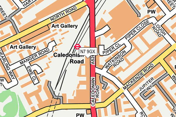
N7 9GX is located in the Laycock electoral ward, within the London borough of Islington and the English Parliamentary constituency of Islington South and Finsbury. The Sub Integrated Care Board (ICB) Location is NHS North Central London ICB - 93C and the police force is Metropolitan Police. This postcode has been in use since November 2013.


GetTheData
Source: OS OpenMap – Local (Ordnance Survey)
Source: OS VectorMap District (Ordnance Survey)
Licence: Open Government Licence (requires attribution)
| Easting | 530574 |
| Northing | 184942 |
| Latitude | 51.548270 |
| Longitude | -0.118258 |
GetTheData
Source: Open Postcode Geo
Licence: Open Government Licence
| Country | England |
| Postcode District | N7 |
| ➜ N7 open data dashboard ➜ See where N7 is on a map ➜ Where is London? | |
GetTheData
Source: Land Registry Price Paid Data
Licence: Open Government Licence
Elevation or altitude of N7 9GX as distance above sea level:
| Metres | Feet | |
|---|---|---|
| Elevation | 30m | 98ft |
Elevation is measured from the approximate centre of the postcode, to the nearest point on an OS contour line from OS Terrain 50, which has contour spacing of ten vertical metres.
➜ How high above sea level am I? Find the elevation of your current position using your device's GPS.
GetTheData
Source: Open Postcode Elevation
Licence: Open Government Licence
| Ward | Laycock |
| Constituency | Islington South And Finsbury |
GetTheData
Source: ONS Postcode Database
Licence: Open Government Licence
| January 2024 | Burglary | On or near Yoke Close | 174m |
| January 2024 | Burglary | On or near Blundell Street | 441m |
| January 2024 | Criminal damage and arson | On or near Eden Grove | 451m |
| ➜ Get more crime data in our Crime section | |||
GetTheData
Source: data.police.uk
Licence: Open Government Licence
| Caledonian Road Station (Caledonian Road) | Caledonian Road | 18m |
| Caledonian Road Station (Caledonian Road) | Caledonian Road | 132m |
| Caledonian Rd Market Rd Gardens (Market Road) | Caledonian Road | 173m |
| Market Road Gardens (Market Road) | Caledonian Road | 191m |
| North Road Hillmarton Road (Hillmarton Road) | Lower Holloway | 212m |
| Caledonian Road Underground Station | Caledonian Road | 32m |
| Holloway Road Underground Station | Holloway Road | 603m |
| Highbury & Islington Underground Station | Highbury & Islington | 1,058m |
| Arsenal Underground Station | Arsenal | 1,377m |
| Tufnell Park Underground Station | Tufnell Park | 1,692m |
| Caledonian Road & Barnsbury Station | 0.6km |
| Drayton Park Station | 1km |
| Highbury & Islington Station | 1km |
GetTheData
Source: NaPTAN
Licence: Open Government Licence
GetTheData
Source: ONS Postcode Database
Licence: Open Government Licence


➜ Get more ratings from the Food Standards Agency
GetTheData
Source: Food Standards Agency
Licence: FSA terms & conditions
| Last Collection | |||
|---|---|---|---|
| Location | Mon-Fri | Sat | Distance |
| Mackenzie Road/ | 17:30 | 12:00 | 167m |
| 492 Caledonian Road | 17:30 | 12:00 | 266m |
| North Road | 17:30 | 12:00 | 384m |
GetTheData
Source: Dracos
Licence: Creative Commons Attribution-ShareAlike
| Facility | Distance |
|---|---|
| The Gym Group (London Caledonian Road) Sterling Way, Sterling Way, London Health and Fitness Gym | 200m |
| St Davids Church Hall (Closed) Westbourne Road, London Studio | 321m |
| Islington Tennis Centre Market Road, London Health and Fitness Gym, Indoor Tennis Centre, Studio, Outdoor Tennis Courts | 346m |
GetTheData
Source: Active Places
Licence: Open Government Licence
| School | Phase of Education | Distance |
|---|---|---|
| Sacred Heart Catholic Primary School 68 Georges Road, Holloway, London, N7 8JN | Primary | 400m |
| Robert Blair School and Children's Centre Brewery Road, Islington, London, N7 9QJ | Primary | 461m |
| New River College Secondary Lough Road, London, N7 8RH | Not applicable | 514m |
GetTheData
Source: Edubase
Licence: Open Government Licence
The below table lists the International Territorial Level (ITL) codes (formerly Nomenclature of Territorial Units for Statistics (NUTS) codes) and Local Administrative Units (LAU) codes for N7 9GX:
| ITL 1 Code | Name |
|---|---|
| TLI | London |
| ITL 2 Code | Name |
| TLI4 | Inner London - East |
| ITL 3 Code | Name |
| TLI43 | Haringey and Islington |
| LAU 1 Code | Name |
| E09000019 | Islington |
GetTheData
Source: ONS Postcode Directory
Licence: Open Government Licence
The below table lists the Census Output Area (OA), Lower Layer Super Output Area (LSOA), and Middle Layer Super Output Area (MSOA) for N7 9GX:
| Code | Name | |
|---|---|---|
| OA | E00013754 | |
| LSOA | E01002765 | Islington 015D |
| MSOA | E02000568 | Islington 015 |
GetTheData
Source: ONS Postcode Directory
Licence: Open Government Licence
| N7 8TB | Caledonian Road | 42m |
| N7 8TP | Cottage Road | 78m |
| N7 8UQ | Roman Way | 99m |
| N7 8TD | Caledonian Road | 100m |
| N7 9PT | Pedlars Walk | 110m |
| N7 8HY | Georges Road | 116m |
| N7 8EU | Watkinson Road | 123m |
| N7 9BA | Caledonian Road | 128m |
| N7 8UN | Roman Way | 130m |
| N7 8QZ | Mackenzie Road | 144m |
GetTheData
Source: Open Postcode Geo; Land Registry Price Paid Data
Licence: Open Government Licence